

GreyHat
-
Posts
388 -
Joined
-
Last visited
Content Type
Profiles
Blogs
Forums
American Weather
Media Demo
Store
Gallery
Everything posted by GreyHat
-

Feb 22nd/23rd "There's no way..." Storm Thread
GreyHat replied to Maestrobjwa's topic in Mid Atlantic
As stated by Terpeast those totals would be cut. My question is instability in the atmosphere. Can there be thunder? -
Feb 22nd/23rd "There's no way..." Storm Thread
GreyHat replied to Maestrobjwa's topic in Mid Atlantic
Thank you -
Feb 22nd/23rd "There's no way..." Storm Thread
GreyHat replied to Maestrobjwa's topic in Mid Atlantic
Thank you, I asked since some times Kuchera has higher totals. -
Feb 22nd/23rd "There's no way..." Storm Thread
GreyHat replied to Maestrobjwa's topic in Mid Atlantic
Thank you for the honest perspective. Maybe one day they can have low ratios besides 10:1 for storms like this. -
Feb 22nd/23rd "There's no way..." Storm Thread
GreyHat replied to Maestrobjwa's topic in Mid Atlantic
Not blaming you, you didn't start with negative comments. Maybe everyone would be better off following Mappy advice. mappy Posted 4 minutes ago Okay that’s enough yall. The back and forth with GH is stupid. Ignore and move along -
Feb 22nd/23rd "There's no way..." Storm Thread
GreyHat replied to Maestrobjwa's topic in Mid Atlantic
Thank you for the additional info. -
Feb 22nd/23rd "There's no way..." Storm Thread
GreyHat replied to Maestrobjwa's topic in Mid Atlantic
Nice to see a picture of you. How this went from talking about the weather. To negative comments on someone who didn't say anything negative to anyone. If you all stop I go away again. May only ask a question here and there. -
Feb 22nd/23rd "There's no way..." Storm Thread
GreyHat replied to Maestrobjwa's topic in Mid Atlantic
Thanks, but I didn't start with the negative comments on anyone. -
Feb 22nd/23rd "There's no way..." Storm Thread
GreyHat replied to Maestrobjwa's topic in Mid Atlantic
You don't know me and I don't care to know you. -
Feb 22nd/23rd "There's no way..." Storm Thread
GreyHat replied to Maestrobjwa's topic in Mid Atlantic
I guess reality is hard for you. -
Feb 22nd/23rd "There's no way..." Storm Thread
GreyHat replied to Maestrobjwa's topic in Mid Atlantic
Better than posting. Wouldn't you agree? -
Feb 22nd/23rd "There's no way..." Storm Thread
GreyHat replied to Maestrobjwa's topic in Mid Atlantic
So, your point? I asked a question, or can't you answer the question? -
Feb 22nd/23rd "There's no way..." Storm Thread
GreyHat replied to Maestrobjwa's topic in Mid Atlantic
Can't help you you drool over maps that show unrealistic amounts of snow. The crap in my toilet is as bad as your Ravens. -
Feb 22nd/23rd "There's no way..." Storm Thread
GreyHat replied to Maestrobjwa's topic in Mid Atlantic
We are having heavy thunderstorm here Magnolia Delaware. Like to see that instability in the Sunday storm. Maybe that would help you all out. Any possibility of thunder during it? -
Right now before any mix bag, we have had ,20" rain yesterday and getting heavy rain now and actually had some thunder. Scared the dogs with the heavy thunderstorm.
-
Feb 22nd/23rd "There's no way..." Storm Thread
GreyHat replied to Maestrobjwa's topic in Mid Atlantic
Snow fall maps are waste, with temps, rain, wet ground. You need to keep expectations down. @mitchnick nws has the right idea 1-3" if your lucky on grass areas. Higher elevation may see more. The rain will be a welcoming sight for water tables. I like snow like everyone else and wouldn't mind a government delay opening. -
It was a joke that I've heard. I'll see myself back out.
-
I'm not a met and don't pretend to be one. I see I hit a sore spot on a joke that I've heard. You all have fun poking me. It was a joke get over it.
-
Thank you for the history lesson. Much appreciated.
-
Don't shoot the messenger. The best thing about those who are Mets, you can be 100% wrong just about all the time. Still keep your job.
-
Thank you, as I highlighted your first sentence. Over here our 5 day outlook is rain Friday and Sunday.
-
Thanks for thinking of me. But been screwed last time you all saw the digital snow. Turned out to be rain. I said earlier wait till Friday and I would believe it otherwise it's a nice rain event.
-
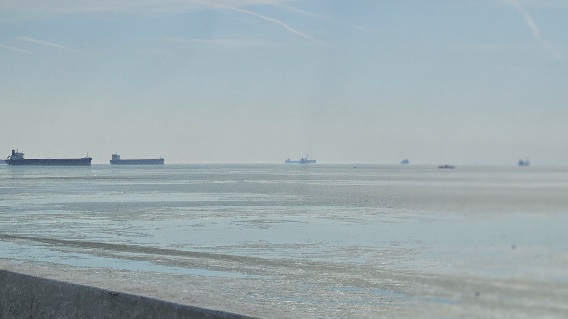
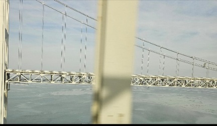
This past Monday, the ice moving in the bay and surrounded the ships anchored below the bay bridge. The second one is the channel blocked by ice from it moving towards the bay bridge.
-
I've seen this happen before when the models were on board. Back then the Euro was labeled King. Back then I followed a lot on wxdisco.com. Just saying I'm not getting my hopes up till Friday. I like the reading and everyone thoughts.
-
Okay, I see your point


