
KChuck
-
Posts
497 -
Joined
-
Last visited
Content Type
Profiles
Blogs
Forums
American Weather
Media Demo
Store
Gallery
Everything posted by KChuck
-
2025 Spring/Summer Mountain Thread
KChuck replied to Maggie Valley Steve's topic in Southeastern States
Well that sent me to my dictionary. I can check off my daily learning requirement for the day. -
Not good! Wife and I are leaving Triad to spend weekend with daughter in Greenville. Leaving Saturday morning to go down. Planning to get there between 1 & 2 to try to miss heaviest of rains and storms. Have tickets to play that night. Coming back Sunday following lunch after everything clears out. Hopefully will miss the worst of the storms.
-
-
Pick one...any one. I'm sure you'll find something you like. If not, no problem. We'll make something up on the spot.

-
More like...
-
Edit: Three days BEFORE the storm
-
Three days
-
Must be a trend then. Went out shopping with the wife in Kville this am and she remarked her iphone temperature forecast was off. Actual temp was quite a few degrees above forecast.
-
That's why you're getting paid the big bucks!!!
-
Me getting head start on shoveling the predicted show. Getting my picture in early.
-
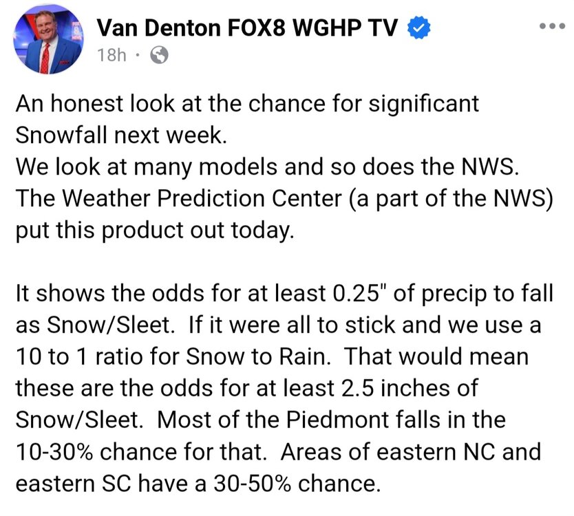
Found this FB post by WGHP's Van Denton to be right on!

-
1/10-11 super awesome winter SE OBS thread
KChuck replied to strongwxnc's topic in Southeastern States
Cause we aren't puppies with cold noses??? . Didn't check my board but looks like we got about an inch of snow then half inch of sleet. No sign of fr. -
1/10-11 super awesome winter SE OBS thread
KChuck replied to strongwxnc's topic in Southeastern States
We may be done for a while. Watched wxii Lanie Pope who is showing us in an upcoming dry slot for a good while. Just took daughter's dog out and nothing much going on outside weather wise north of Kernersville. -
There was also a Greensboro NWS radar station decommissioned probably about that time. This caused a lot of problems for the area as we've observed more than our share of tornados lately.
-
We wish!
-
I was thinking the Weather Channel
-
Lilj4425 I believe that the floor is yours!
-
Corollary for a watched pot never boils is a watched model never pleases.
-
I'm hoping it hugs us!
-
Seems I recall that there has mostly always been a sharp gradient in the I85 storms in North Carolina, not specific to Raleigh only.
-
Again, so true!
-
And this is different from what lately???
-
I was thinking that with the low dew points and cold temperatures that we'd be starting off with fluffy snow at better than 10:1 ratios then watch them collapse as the mixed precip and rain comes in, no?