WeatherGeek2025
-
Posts
1,682 -
Joined
-
Last visited
Content Type
Profiles
Blogs
Forums
American Weather
Media Demo
Store
Gallery
Everything posted by WeatherGeek2025
-
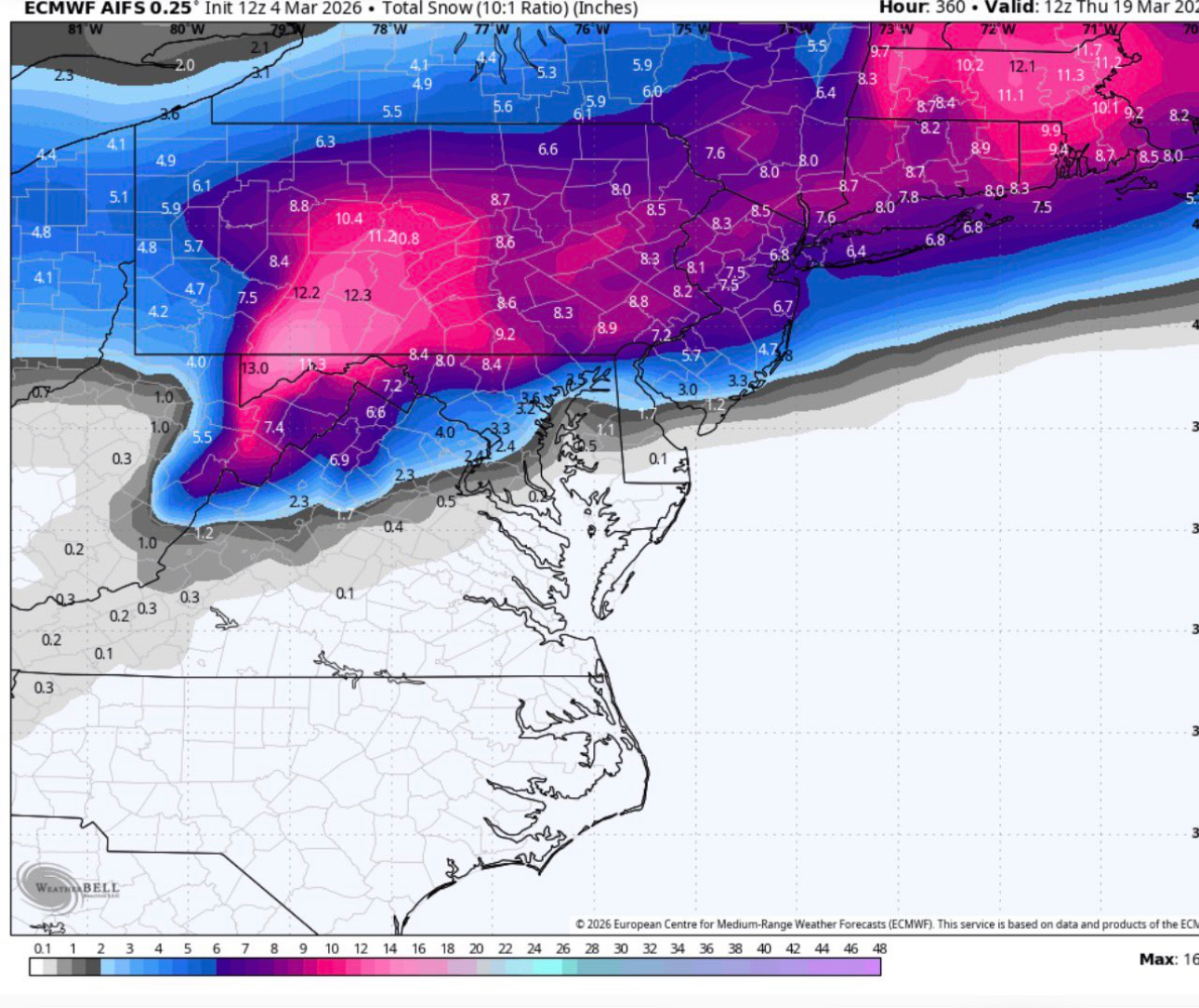
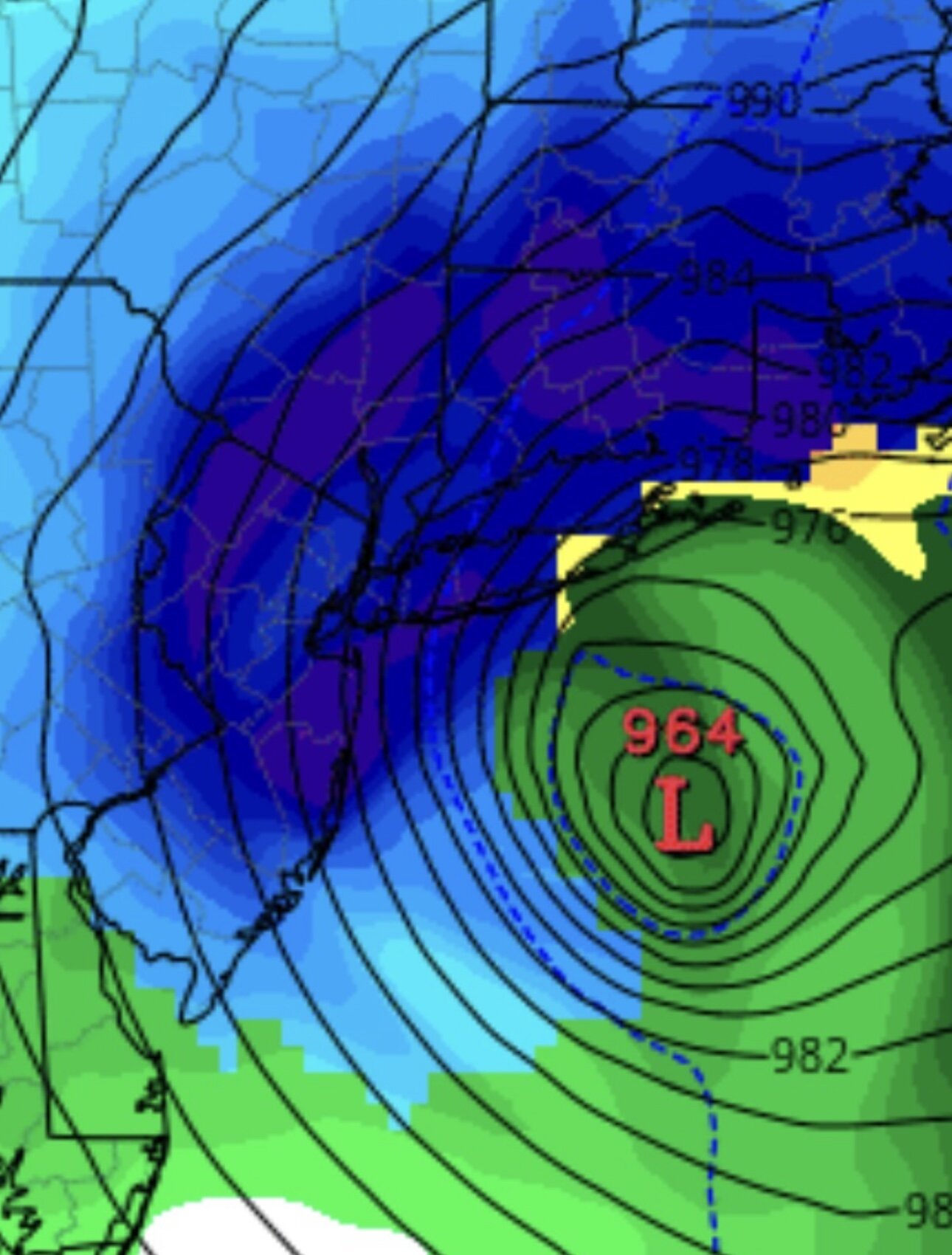
i'm looking at March 13th to March 18th for an overrunning big system that could produce a heavy snowstorm!
-
thank you sir
-
thanks I'll check it out, fyi it's a boys weekend out. We're not taking our wives or kids with us!
-
it's snowing outside
-
Hi my fellow weenies, hope you guys getting some snow today. I have a question, my friends and I are going to Boston from next Wednesday until Saturday. We're looking to explore the city a little bit and maybe hit up the encore casino as well. Since you guys would probably know... We're trying to book a hotel that's close to the city itself where we could go out to maybe a couple of bars and maybe even a club, definitely a couple of good restaurants... We're also planning on going to encore casino for one night maybe a few hours. My question is do you guys have any recommendations for hotels, neighborhoods, restaurants, bars... we're all in married with kids except one of us. he's a single dude. we need something close to the casino as well if we decide to go gamble after the club or whatever. thanks in advance
-
temps dropping
-
it was the same guy that measures today, he's a time traveler... I made a complaint about this to NOAA today on twitter!
-
Bryant Pond Road Putnam county! ScreenRecording_03-03-2026 14-43-21_1.mov
-
March 15th-18th look prime for a big snowstorm for the northeast. I will keep an eye on that timeframe until than we are warm and mostly rainy!
-
light sleet in midtown
-
hey Don can i use your data for my weather page? I understand if you mind!
-
thundersnow this morning?
-

February 2026 OBS & Discussion
WeatherGeek2025 replied to Stormlover74's topic in New York City Metro
48 degrees here with a 6 mph wind out of the southeast. it's nice in the sun for sure -
February 2026 OBS & Discussion
WeatherGeek2025 replied to Stormlover74's topic in New York City Metro
it's not crazy hot, there's a stiff wind out there but we're getting there! -
February 2026 OBS & Discussion
WeatherGeek2025 replied to Stormlover74's topic in New York City Metro
47 already at the Park -
February 2026 OBS & Discussion
WeatherGeek2025 replied to Stormlover74's topic in New York City Metro
thank you sir... why does weather app say 46 it's weird -
watch this overperform. can anyone tell me central parks fridays high?
-
February 2026 OBS & Discussion
WeatherGeek2025 replied to Stormlover74's topic in New York City Metro
anyone know today's high at central park? -
Wilmington, NC
-
true!
-
GFS drops a solid inch Sunday!
-
bro how old r u