

LordBaltimore
-
Posts
189 -
Joined
-
Last visited
Content Type
Profiles
Blogs
Forums
American Weather
Media Demo
Store
Gallery
Everything posted by LordBaltimore
-
I'll take a nina every time. 12" of snow that's a puddle the next day < 2" that sticks around. The only time it's ever worth it is for the 2016 type 2 foot storms but that's a huge gamble.
-
I just ordered some. Won't be here till tuesday so better stay cold or else they're just a self defense item I guess
-
Had to drive out about 15 miles to the Montgomery county agricultural history farm park this morning to see negatives. My wife now thinks I'm a nutjob. But it was worth it. Low of 4 degrees at home
.thumb.jpg.a7d3adc7b397e29dab7a6f29af8ab9a6.jpg)
-
Rivers are always more risky just b/c of how currents impact freeze up. Some of the tidal areas could be walkable in a matter of days, as well as any fast ice on shores of Chesapeake. Walking on some part of the bay is on my bucket list so I will be reporting on that when it's at least conceivably safe lol
-
If GFS is right with long range progression I will be walking to Hart-Miller Island
-
low of 6 at ****130am**** I have never been more pissed at wind in my life. Denyed yet again
-
sounds like right in front of the garage is a good place to dump snow for next time
-
had to do a double take because I'm moving to a house in Baltimore next week that has that exact setup, lmao. End of group house on alley with concrete pad and people with garages up the alley. Hope this isn't a common theme
-
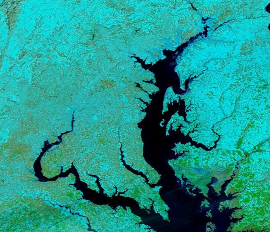
Corrected reflectivity showing extent of Chesapeake bay ice as of this morning. Should start to explode tonight with calm winds
-
it's a radiational cooling night now that the winds are dying off. There's probably a 5+ degree difference between different sides of your house depending on sky exposure and distance to heat sources. Many parts of the city will reach single digits
-
Everybody saddle up. Set your alarms. Make sure your outdoor temp sensors are in working order and properly sited. Tonights the night We're going sub-zero
-
Hoping the precip shield extent is being incorrectly modeled and we can at least cash in on a 2-4" type deal. Morning runs look like a close scrape so we could still cash in if that's the case
-
I'm not super familiar with the land surface part of modeling but I really wonder if the reason models have busted on min temps so far is that they had the surface progged as snowpack when it's really a sheet of ice at this point. It's easy to get very low skin temps with snow b/c of insulation, but harder with ice because of heat conduction from below
-
I don't believe so. AIFS takes Euro analysis members and uses them as input to an ensemble of AI models. AIFS and AIGFS aren't bad really since they're run by met centers. It's the "observation driven" models where you see the most shady verification practices.
-
Any physical model + postprocessing with same ERA5 dataset would beat anything AI is capable of when trained as a forecasting model. I'm not sure why this isn't done already tbh
-
Good idea to not trust it. The verification process for many of these models (especially anything not fed analysis data as input) is extremely suspect almost to the point of being an outright scam, although most cases I think are just incompetence. A lot of their claimed advantage is just removing representation error
-
Regardless of outcome this is a really interesting setup. Normies talk about how models can give/take-away 2 feet of snow four days out but this is a perfect example of how nonlinear dynamics can make huge things impossible to predict with certainty even at close range
-
Seems like every model pretty much has a bimodal distribution of members OTS vs nearby, with significant uncertainty, and the deterministics are just honing in on different peaks of that distribution
-
If the GFS wins here by some miracle I don't ever want to hear people badmouthing it ever again. And that includes myself
-
Really hoping the weekend threat materializes. I carved a set of snow/ice/sleet steps into the hill that leads down to my parking spot, and a meltdown two weeks from now without some fluff to insulate it would be a critical hit to my personal infrastructure
-
TERRAIN! TERRAIN! PULL UP! PULL UP!

-
Lessons From January 24-26th Winter Storm
LordBaltimore replied to SnowenOutThere's topic in Mid Atlantic
I think you indirectly hit on something many people discover in their 20's. No, it is not enjoyable to track a storm every model run for 7 straight days. It's an obsession. But you don't become an expert in anything without being at least a little bit obsessed. And in that fact lies a trade off. Is this for fun, or is it something you dedicate your life to for it's own sake? Everyone makes that choice on their own -
Question for mets. What factors here determine the extent of the precip shield? Seems rather narrow on GFS for low that deep
-
More than that. If it were physically possible to pull a Tonya Harding on an atmospheric feature to get more snow I would do it with no remorse
-
HRRR says 850 winds die down sometime between 1-4am so hoping that's when temps start dropping out

.jpg.e8d0f94b46bc2ebc7df927d6febc7527.jpg)


