

IrishRob17
-
Posts
11,758 -
Joined
-
Last visited
Content Type
Profiles
Blogs
Forums
American Weather
Media Demo
Store
Gallery
Everything posted by IrishRob17
-
The last of my natural snow cover went today, still plenty of piles.
-
After a high of 80 today the peepers are loud and proud.
-
I expected to be fringed by that storm, like I was in 2006 but was pleasantly surpised to cash in on those 18". There was some great drifting both from the storm and the days after.
-
79, almost time for AC installs.
-
And the first who first posted that way too far out crappy snow accumulation map would be the first to call out someone else as banter and pointless to post a map that far out if it showed no snow.
-
I have a little bit on a shady north facing slope and piles of course but even those are going fast. It was weird driving to work this morning without any snow banks aloong the roads, its been a while.
-
Inside 400 hours, nice. What could go wrong?
-
An over performer on the temps today, up to 65.
-
Just a trace left at the stake, still patches of snow in the yard and woods. Overnight temps in the mid to upper 40s, with the dews to match, did a number on the snow.
-
Well how else do the flowers start growing?
-
3" at the stake this morning. Not only warm tonight but the dews are forecast to jump into the low 50s here, heavy melt I would expect if it plays out like that.
-
Tomorrow night is going to be warm, that will really put a dent in it.
-
Yeah, I'd be curious what the snow depth difference is between the two the day after the snowfall.
-
Could use that melting now, an icy mess up here in many spots this morning, back down to 31 now.
-
@The 4 Seasons.9" was my highest depth for yesterday and then freezing rain in top, still hovering between 32-33° now.
-

2/24 - 2/25 Clipper Obs (1 - 2" for many on forum)
IrishRob17 replied to Northof78's topic in New York City Metro
.6" for me if you don't already have it. -
29° with huge snowflakes again.
-
I was under a great band this morning, quite possibly the best flakes all season.
-
And I don’t believe that they were clearing any boards every six hours.
-
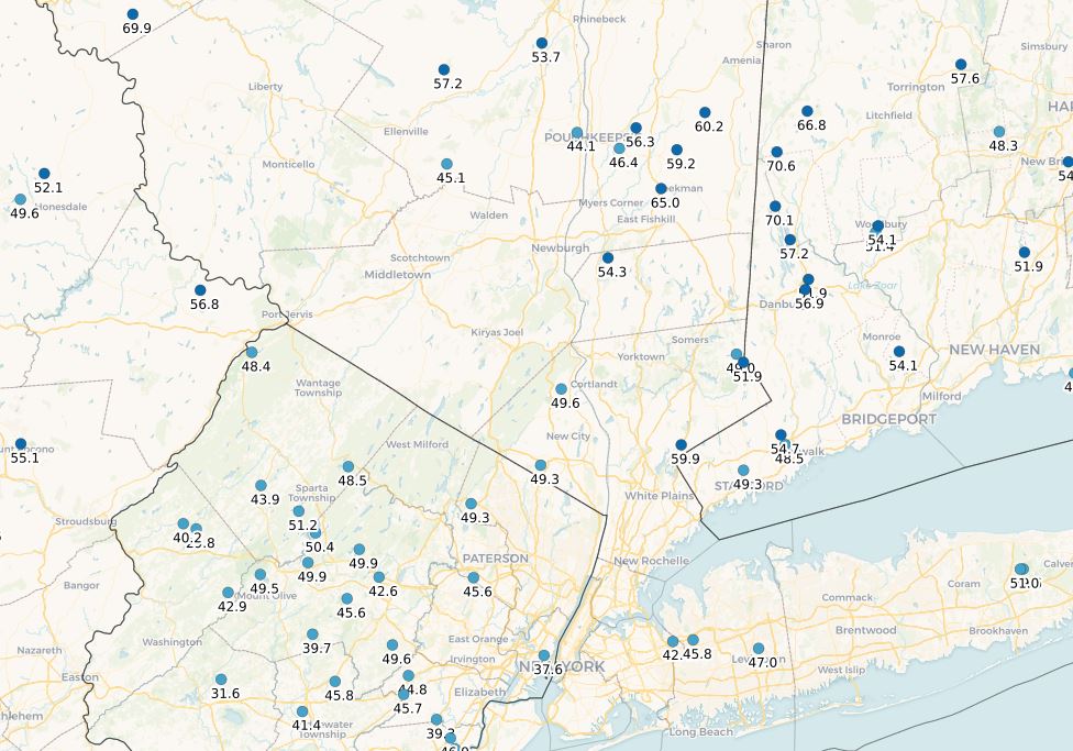
It's the CoCoRaHS map. That total almost due north of me in Ulster is damn close to my total. I've thought about it sometimes but clearly never joined, you ever think about it? I know you are really passionate about snowfall records. Are you from Manhattan orignally? @The 4 Seasonsmaps are the best I've seen.
-
Snowfall from 12/1/25-3/1/26
-
Just looking at my meteorological winter stats, this year has my lowest highest temp of 56. The next lowest high temp was 58 in 2014-2015. This season also has my lowest warmest minimum temp of 33.
-
Snywx is just under 52", a 6-7" difference in annual totals is common between his location and mine. My elevation is only around 400' and being in the Wallkill River valley has its own impacts. What will always sting me a bit about this winter is only getting 6.6" of snow in February.
-
13° for the low here as well with 4.5" at the stake. .3" yesterday, 45.4" for the season.
-
.3 this morning, 45.4” for the season.


