Jump to content

IrishRob17

Members
  • Posts

    10,709
  • Joined

  • Last visited

Everything posted by IrishRob17
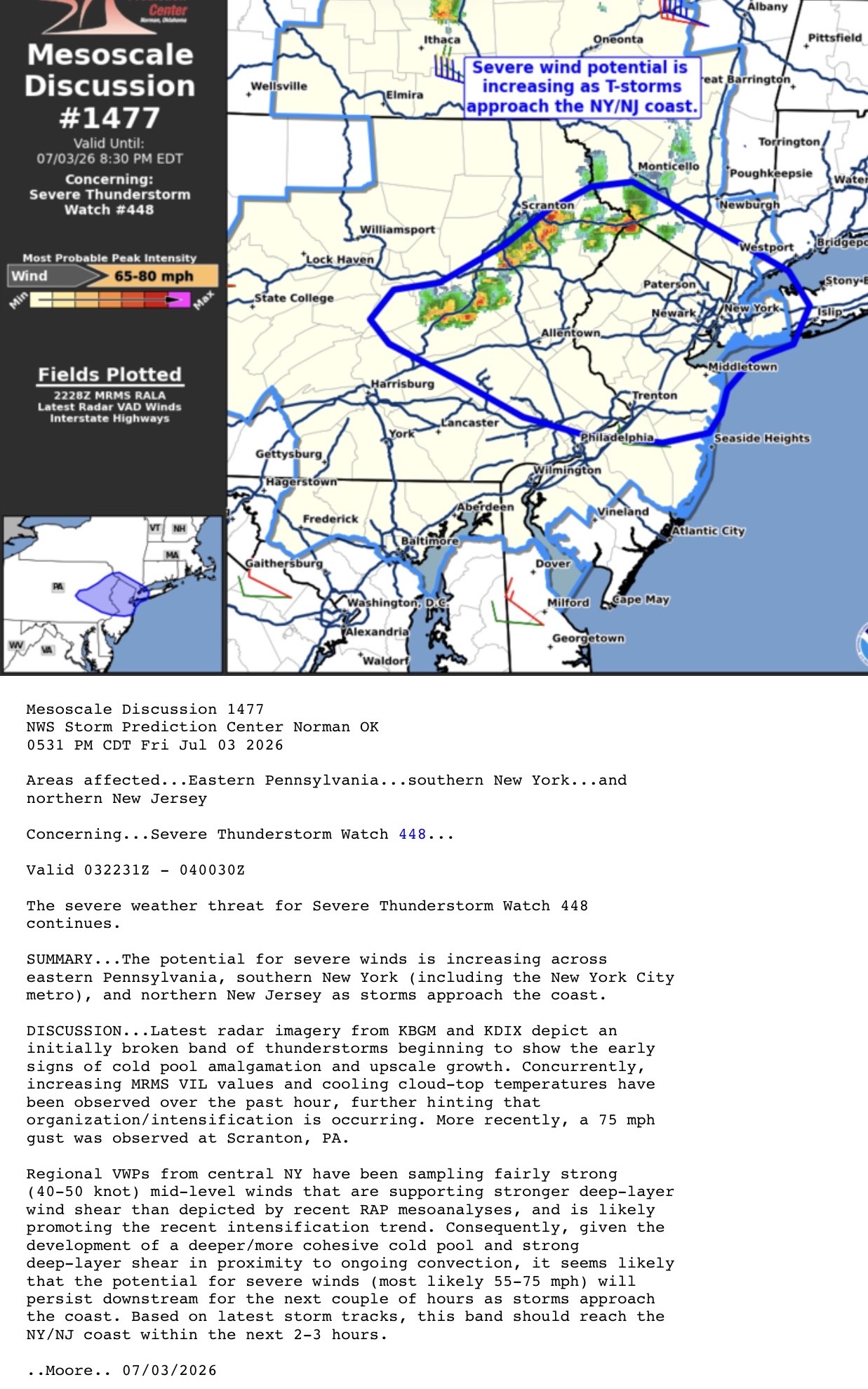
  1. Moderate to heavy snow again now 33/32
  2. 2.6" on the board at 6:15am down here at just under 400' elevation. A grass measurement nets be anywhere from .5 to 1.5 more depending on which clump of grass I measure by LOL
  3. Waiting might have cost you the max snow depth. I had 2.6” on the board when I measured at 6:15am it was 2.6” but down to 2.3” when I just came in, a mixed of snow, sleet, and rain here. 33/31
  4. Over performer IMBY. I have to measure, and might have to get out my snow shovel again, wasn't expecting to have to shovel. I figured it would be a mostly grass/car topper event here.
  5. WWA posted for part of Uptons area
  6. A coworker who takes 84 from PA reported snow up on Greenville Mountain this morning, not shocking there.
  7. I'm at 29.6" for the season so part of me is rooting for .4 of meaningless April snow to get to 30" on the season which is still a sad number...
  8. I’d believe Pine Bush has snow, there are a bit further NW from me and have more elevation. I’m tucked in along the Wallkill River so marginal events are tough here. The flip side is sometimes I can hold onto the cold much longer in the dead of winter.
  9. I saw some white rain drops at times but nothing I would consider snow and there is nothing out there now that I can see. 35/34
  10. https://www.nysmesonet.org/weather/maps/Tmin-2m 27 for the low here. My average last freeze date is 4/25
  11. There was a midnight high of 46 here overnight but dropped into the 30s just before 6am and have been there ever since. 38/36 currently with occasional drizzle and mist.
  12. The vegetation/woods are typically tinder dry this time of year until every thing greens up. That's why NY has the annual burn ban from March into May.
  13. That western batch just moved through, a total of .17 through the tipper, 46/42
  14. Agreed. There was a nice batch of rain out near Scranton but the bulk of it is going to my north, I just getting clipped by the southern edge. Time will tell what happens with that batch out in western PA.
  15. Yeah, I still have plenty of mud that argues against D1, along with measured precipitation stats to back it up. That said, I do not know the metrics that the Drought Monitor uses. We'll see what happens after leaf out and with the future pattern.
  16. Looking at the past 12 months: Actual: 40.96" KMGJ average: 40.99" My average over 20 years: 45.25"
  17. I noticed that the past two months have had above normal precip so that got me to dig in a bit on the water year (starts Oct 1). Here are my numbers over that period: Actual: 16.13" KMGJ average: 18.22" My average over 20 years: 20.24" So we are below average in this neck of the woods but nothing crazy in todays climate.
  18. .91 up here and a tremendous long lasting clap of rolling thunder around 10pm. It lasted so long I was questioning if it even thunder for a few seconds.
  19. From this afternoons SPC update: ...Mid-Atlantic to the Northeast... Model guidance indicates weak buoyancy across the Mid-Atlantic states into the Northeast ahead of the cold front. Appreciable heating has occurred through midday with temperatures rising through the upper 70s deg F. Despite some mixing of boundary-layer moisture, SBCAPE 500-1000 J/kg will support scattered storms developing this afternoon. Steepened 0-2 km lapse rates and moderate low to mid-level flow will probably yield scattered damaging gusts later this afternoon into the evening (55-65 mph).
  20. The dew point is above the dreaded, for some of us, 60 degree line.
  21. From the SPC update: ...Mid-Atlantic to the Northeast... Instability is expected to weaken with northward extent ahead of the cold front across the Mid-Atlantic and Northeast. Still, scattered thunderstorms should develop this afternoon and spread east-northeastward towards the coast through the evening. With enhanced low/mid-level flow present in association with the lead shortwave trough, some of this convection may pose a threat for damaging winds and perhaps a tornado or two, before it eventually moves offshore.
  22. That's was kinda wild, sitting outside, 75 degrees and then the more northerly winds won out and we could feel the cool air moving in like walking into air conditioning, down to 68 now and dropping quickly.
×
×
  • Create New...