IrishRob17
-
Posts
11,757 -
Joined
-
Last visited
Content Type
Profiles
Blogs
Forums
American Weather
Media Demo
Store
Gallery
Everything posted by IrishRob17
-
https://www.spc.noaa.gov/products/md/md1645.html Mesoscale Discussion 1645 NWS Storm Prediction Center Norman OK 1001 AM CDT Sat Jul 18 2026 Areas affected...Northern Mid-Atlantic into southern New England Concerning...Severe potential...Watch unlikely Valid 181501Z - 181630Z Probability of Watch Issuance...20 percent SUMMARY...Isolated wind damage is possible with strong to marginally severe storms late this morning. A watch is not expected. DISCUSSION...A small linear cluster of storms has recently organized in northern New Jersey and adjacent northeast Pennsylvania. Storm cores have shown modest deepening on 7 km MRMS CAPPI over the last 30 minutes. The observed OKX sounding had poor mid-level lapse rates (5.3 C/km) but 45 kt of effective shear. Downstream of this current activity, cloud cover and smoke have hindered surface heating. Low-level lapse rates are not expected to be overly steep. While isolated wind damage is possible late this morning, the severe threat should remain marginal on account of very limited buoyancy. A watch is not expected. ..Wendt/Thompson.. 07/18/2026
-
The ground smoke mixed out here hours ago too.
-
Satellite shows the smoke has pushed south but it’s deceiving, still lots of lingering ground level smoke easily seen when outside.
-
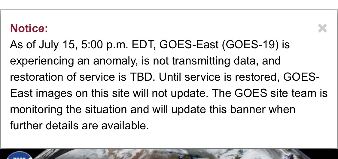
Looks like GOES-East might be back.
-
Here's the reason

-
Satellite is messed up this morning, it’s not updating for some reason.
-
I agree it's not as bad as 2023 yet but we do have snoke drifting through the air at ground level up here.
-
80° at 5:30am up here in the sticks is just plain stupid.
-
Low of 74° at 2:59am and 80° now at 5:30am, which is insanity for these parts.
-
I'm hoping to luck out next Saturday for Freedom Fest in the park.
-
Still getting intermittent drizzle/light rain randomly, another .01" in the last hour. Not much but it don't help with trying to dry things out.
-
7.43" for this event, 7.56" for the month. Picked up another .01 in the last hour, maybe today it actually stops, it should.
-
Just hit 7.00" and still raining.
-
Up to 6.51” and raining at about .25” per hour rate now.
-
Latest WPC discussion: https://www.wpc.ncep.noaa.gov/metwatch/metwatch_mpd_multi.php?md=0629&yr=2026
-
I'm up to 6.44"
-
Up to 6.44" for the event.
-
My son over near Milford PA is at 6”. Hopefully that power gets back on soon!
-
The models did a decent job showing it was going to dump somewhere and as you stated the exact the locations are always going to move around in these types of setup’s. I got under that band but other places in Orange County received much less. Everyone in the region getting 3-5+” was never likely and most of us knew that but not everyone reads the actual discussions, they just look at the pretty graphics on their phone app.
-
Up to 5.25” and still raining but the current rate is a much more manageable .26” per hour.
-
4.76" since 7pm last night here near Campbell Hall.
-
Spoke too soon on the rainfall rate, up over 2.5” now in the past two hours.
-
Just over 2” since 7pm, rainfall rate is down at the moment but this cell keeps back building with a new cell to the west moving this way. Flash Flood Warning issued until midnight.
-
Rainfall rate has been bouncing between 3-7" per hour, up to 1.25" and pouring.
-
Now that is split a bit I'm u see the bullseye of the southern cell, up to .73" over the last hour or so, streams running through the yard.