

IrishRob17
-
Posts
10,179 -
Joined
-
Last visited
Content Type
Profiles
Blogs
Forums
American Weather
Media Demo
Store
Gallery
Posts posted by IrishRob17
-
-
1 hour ago, Stormlover74 said:
39 with sleet and lightning at the Kansas/ Oklahoma game
Air Force at Colorado State at 7pm tonight on CBS Sports Network should have some snow
-
Made it to 79, “cooler” now at 76 as the clouds moved in.
-
Currently 66/58, sitting on the deck in shorts and a T-shirt, no hoodie required after a high of 77 for the day. Just plain stupid.
-
 2
2
-
-
Clear blue skies and bright sun for the past 90 minutes or so, temp up to 73 IMBY, up to 75 at Legoland in Goshen.
-
1
-
-
80 degrees but hey, that's not as much above normal as other places so I guess it feels kinda cool out?
-
 1
1
-
-
2 hours ago, wdrag said:
Finally: fwiw... your color may be pretty good where you are, and we certainly have some, but this is not nearly as colorful a year here in this part of nw NJ as compared to last. Maples lost their leaves too soon, and much less color. More yellows than reds.
That's how it was in my area too, there's the occasional tree that looks good but overall not so great. The winds Sunday into earlier this week didn't help any.
-
1
-
-
On 10/13/2023 at 8:54 AM, IrishRob17 said:
Here are some fall average dates IMBY:
First low 36 or below (NWS definition of frost): 10/11
First Visible Frost (obviously nothing scientific with this one): 10/15
First 32 or below low: 10/22
First Hard Freeze (NWS definition of 28 or below): 10/30
The lowest IMBY this season thus far is 40 with no 30's in the forecast at least for the next week.
For this season so far:
First low 36 or below (NWS definition of frost): 10/24 34
First Visible Frost (obviously nothing scientific with this one):
First 32 or below low:
First Hard Freeze (NWS definition of 28 or below):
-
1
-
-
44 for the low at KMGJ, average is 38.
-
15 minutes ago, bluewave said:
It’s all about proportionality. Sure it feels chilly out there this morning. But the cold is nowhere near a record. Highs in the low 80s later this week is near the record. We would need lows in the 20s to set a record. That’s what people are saying. Several of our recent winters since 15-16 were near the warmest on record. But even a winter averaging around or over 40° or warmer feels chilly outside and you will still need a jacket on most days.
Newark Area, NJ
Version: 18.2 (created 2023-09-05)
Period of record: 1893 through 2022DateLowest minimum temperatures (degrees F)10/25 31 in 1907 31 in 1903 33 in 1939+ 10/26 31 in 1952 31 in 1936 31 in 1933+ 10/27 27 in 1936 29 in 1976 29 in 1907 10/28 25 in 1936 27 in 1904 29 in 1976 10/29 29 in 1904 30 in 1965 30 in 1940 10/30 31 in 1952 31 in 1910 31 in 1902 10/31 27 in 1904 29 in 1975 30 in 1910+
Newark Area, NJ
Period of record: 1893-01-01 through 2023-10-22DateHighest maximum temperatures (degrees F)10/25 79 in 2001 79 in 1963 78 in 2021 10/26 79 in 1964 79 in 1963 78 in 1989+ 10/27 81 in 1963 80 in 1947 78 in 1989 10/28 82 in 1984 81 in 1919 78 in 1989+ 10/29 78 in 1971 78 in 1946 76 in 1989 10/30 82 in 1946 80 in 1961 80 in 1950 10/31 82 in 1946 79 in 1950 77 in 1945 Agreed, people just aren’t acclimated yet. Yesterday KMGJ had a high of 54, average is 60 so 6 degrees below the normal high. Highs at the end of the week are looking to be at least 15 degrees above average. The low yesterday was 43 when the average is 38 so yesterday as a whole the day averaged a ‘whopping’ half of a degree below average.
-
2
-
 1
1
-
-
.34 on the day and zero FOMO
-
.25
While about 80% of the leaves are down in my yard, I'm happy to see that the trees in my neck of the woods in general that didn’t drop brown and early are starting to show some color.
-
51 minutes ago, Stormlover74 said:
Quite the comeback. It was looking dire after 3
They didn't cover
-
2
-
-
3 hours ago, Will - Rutgers said:
i don’t want to hear it from you babies about how the weekend isn’t nice again. your ancestors killed and ate two of every animal with clubs and spears i don’t want to hear about 50 degrees and light rain. i am walking the park in gym clothes i know you can do it too
Coping skills are lacking for many these days
-
2
-
1
-
 1
1
-
-
I have one rose that bloomed in the past couple days, two new buds on another rose and a lillie that just bloomed today. Nothing to see here...
-
Here are some fall average dates IMBY:
First low 36 or below (NWS definition of frost): 10/11
First Visible Frost (obviously nothing scientific with this one): 10/15
First 32 or below low: 10/22
First Hard Freeze (NWS definition of 28 or below): 10/30
The lowest IMBY this season thus far is 40 with no 30's in the forecast at least for the next week.
-
3
-
-
7 hours ago, forkyfork said:
just think: in winter all this rain will translate to colder rain
But it will feel cold
-
9 hours ago, MJO812 said:
That's cool
Isn't 72 today 5 or 6 degrees above average for Brooklyn?
-
1
-
-
Around 50% leaf drop IMBY, mostly brown and yellow unfortunately
-
1.00" final. 52/49.
-
-
17 minutes ago, bluewave said:
NYC is on track for another 50”+ year with numerous sites around the area already over 50”.
Data for January 1, 2023 through October 6, 2023
Click column heading to sort ascending, click again to sort descending.StateNameStation TypeTotal PrecipitationCT SEYMOUR 1.2 WSW CoCoRaHS 57.56 NY WEST POINT COOP 56.70 CT ANSONIA 1 NE COOP 53.38 CT PROSPECT 1.9 ENE CoCoRaHS 53.11 NY PEEKSKILL 0.4 N CoCoRaHS 52.92 NY STONY POINT 0.7 NW CoCoRaHS 52.56 CT NORWICH 2.5 NNE CoCoRaHS 52.48 NY THORNWOOD 0.7 NW CoCoRaHS 51.99 CT NORTHFORD 0.8 SW CoCoRaHS 51.99 CT EAST LYME 0.5 SW CoCoRaHS 51.82 CT WATERBURY 1.3 WNW CoCoRaHS 51.72 NY NEW HEMPSTEAD 0.6 SE CoCoRaHS 51.51 CT BROOKFIELD 3.3 SSE CoCoRaHS 50.76 CT GRISWOLD 0.9 N CoCoRaHS 50.61 NY SHRUB OAK COOP 50.59 NY BEACON 4.2 ESE CoCoRaHS 50.37 CT MIDDLEFIELD 0.6 SE CoCoRaHS 50.14 CT PROSPECT 0.5 SW CoCoRaHS 50.00 CT NAUGATUCK 1.7 NNE CoCoRaHS 49.50 NY CARMEL 4N COOP 49.46 CT MERIDEN 2.8 WSW CoCoRaHS 49.39 NY SOUTH SALEM 2.1 NW CoCoRaHS 49.26 CT BETHANY 1.3 SW CoCoRaHS 49.26 NY PORT JERVIS 2.9 ESE CoCoRaHS 49.22 NY SOUTH SALEM 0.8 N CoCoRaHS 49.10 CT COLCHESTER 0.6 ENE CoCoRaHS 48.99 CT NEWTOWN 4.6 SE CoCoRaHS 48.98 CT HIGGANUM 0.8 NE CoCoRaHS 48.68 CT DURHAM 1.2 W CoCoRaHS 48.64 CT WALLINGFORD CENTER 1.9 WNW CoCoRaHS 48.62 CT RIDGEFIELD 2.4 NNE CoCoRaHS 48.35 CT NEW CANAAN 1.9 ENE CoCoRaHS 48.17 NY BROOKLYN 3.1 NW CoCoRaHS 48.10 NY ELMSFORD 0.8 SSW CoCoRaHS 48.09 NY ARMONK 0.3 SE CoCoRaHS 48.05 CT OAKDALE 2.6 WNW CoCoRaHS 47.88 NJ RINGWOOD 3.0 SSE CoCoRaHS 47.73 CT HIGGANUM 0.7 N CoCoRaHS 47.50 NY PINE BUSH 3.4 WSW CoCoRaHS 47.34 NJ WAYNE TWP 2.3 ESE CoCoRaHS 47.31 CT SOUTHBURY 2.3 W CoCoRaHS 47.25 NY LITTLE NECK 0.3 SE CoCoRaHS 47.15 CT JEWETT CITY 3.0 ESE CoCoRaHS 47.10 CT WALLINGFORD CENTER 3.3 NNW CoCoRaHS 46.92 CT SHELTON 1.3 W CoCoRaHS 46.62 CT NORWALK 1.4 ENE CoCoRaHS 46.48 CT OLD LYME 3.4 ESE CoCoRaHS 46.42 CT BETHEL 0.5 E CoCoRaHS 46.33 CT RIDGEFIELD 3.6 N CoCoRaHS 46.13 NJ GLEN ROCK 0.7 SSE CoCoRaHS 46.12 NY LAGUARDIA AIRPORT WBAN 46.00 CT OXFORD WATERBURY WBAN 45.98 CT MONROE 0.8 W CoCoRaHS 45.98 CT NEW CANAAN 3.8 N CoCoRaHS 45.97 CT NORWALK 2.9 NNW CoCoRaHS 45.90 CT SALEM 3.6 SE CoCoRaHS 45.78 NY NY CITY CENTRAL PARK WBAN 45.73 I glanced earlier this week, I’m just under 53” here
-
1
-
-
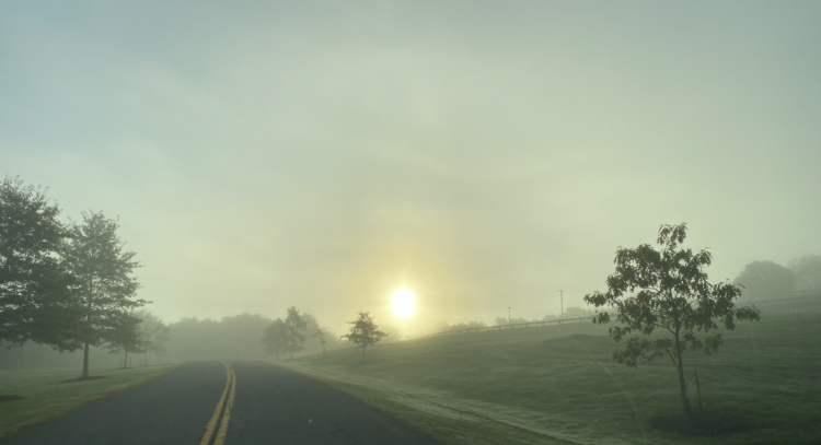
Living along the Wallkill River this is fog season, here's a shot from this morning driving up the hill and out of the fog
-
5
-
1
-
-
10 hours ago, hudsonvalley21 said:
83 for the high here. Dewpts in the mid 60’s made it very summer like. I’m glad that I didn’t shut down the central a/c yet. Feel bad for your climate conditions in your bedroom.

@BxEngineis truly a busy man because you commenting on conditions in my bedroom is a golden opportunity for one of his attempts at humor. Oh well. I was bamboozled by the Hoodie Crowd who despite being in warmer climes were weeks ahead of true hoodie season. Again, oh well. This morning is not quite as dewey as yesterday so it's more tolerable.
-
2
-
1
-
-
3 hours ago, Juliancolton said:
That's 90! October did what August couldn't.
Wow! 83 for the high here, sick of this humidity, wish I didn’t uninstall in my bedroom at least.
-
 2
2
-
Interior NW & NE Burbs 2023
in New York City Metro
Posted
And aren't too hungover to tell the tale.