

IrishRob17
-
Posts
11,695 -
Joined
-
Last visited
Content Type
Profiles
Blogs
Forums
American Weather
Media Demo
Store
Gallery
Posts posted by IrishRob17
-
-
21 minutes ago, Juliancolton said:
My PWS touched 104.0 while others in the area were around the same or 105. Probably 102-103 in reality
It's always a bit more moist here, wait wut, due to being along the river and near a small pond/swamp thus keeping me just a touch "cooler" on days like this.
-
 1
1
-
-
2 hours ago, IrishRob17 said:
KMGJ has been at 100° the past couple hours, impressive.
Three hours.
-
KMGJ has been at 100° the past couple hours, impressive.
-
1
-
-
98/77 currently, high so far was 99.
-
2
-
-
95 for the high here.
-
1 hour ago, donsutherland1 said:
July 4th thread. Its numbers are unreal for NYC.
My screen got hot just looking at the maps, .13" today.
-
1
-
-
24 minutes ago, forkyfork said:
i know the euro came in hot because nobody is posting it
Check the July thread
-
2
-
-
11 minutes ago, IrishRob17 said:
Is it normal to have 8,500 guests on this time of year? Are those online stats accurate?
Up over 9,000 guests now.
-
1
-
-
1 hour ago, dendrite said:
I haven’t gotten through to Johnwow or Randy yet…I think it was Randy’s bday yesterday so he may not be sober for a few days. But it was faster yesterday morning too…almost seems like a bandwidth issue.
Is it normal to have 8,500 guests on this time of year? Are those online stats accurate?
-
2 hours ago, BxEngine said:
Of course i have 2 softball games in the middle of the day thursday

Thoughts and prayers, @forkyforkkeeping score for ya?
-
 1
1
-
-
On 6/26/2026 at 5:17 AM, IrishRob17 said:
@gravityloverI'm you saw the big shift south on the models, looking dry now.
And here come the showers, man the models are all over the place anymore, but they look south of New Paltz for now anyway@gravitylover
-
1 hour ago, Hitman said:
Was it even forecasted to rain last night?
1.16” overnight. 3.14” for the month.
Yes, showers/thunderstorm remnants were expected, the specific loations were to be determined.
-
19 minutes ago, BxEngine said:
Rain and thunder woke me up at 2. Gonna be a longgggg day lol
Thinking about work bullshit woke me up at 4. Gonna be almost as longgggg a day
-
1
-
-
.20" total here.
-
23 hours ago, IrishRob17 said:
The trend doesn't seem to be your friend if you want completely dry but it doesn't look like a wash out either as of now anyway
@gravityloverI'm you saw the big shift south on the models, looking dry now.
-
12 hours ago, gravitylover said:
Do we think Saturday morning will be dry in New Paltz?
The trend doesn't seem to be your friend if you want completely dry but it doesn't look like a wash out either as of now anyway
-
6 hours ago, qg_omega said:
Many saw very little
https://partnerservices.nws.noaa.gov/products/cache/174-2026/PNSOKX/eeeb3abe685ed84229687420768546b6
-
1
-
 1
1
-
 1
1
-
-
-
-
1 hour ago, Stormlover74 said:
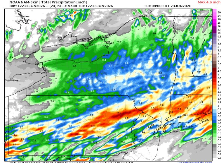
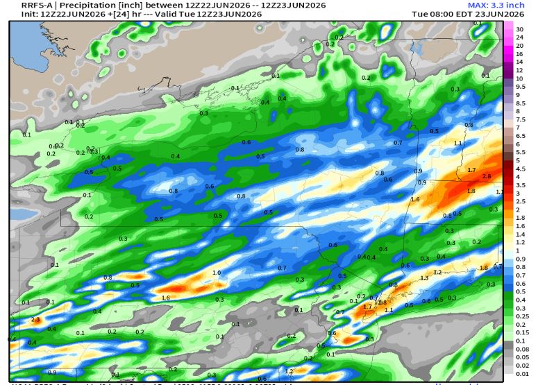
Hopefully the nam has a clue. Wasn't it supposed to be retired by now?
NAM and its replacement
-
37 minutes ago, BxEngine said:
My backyard is covered in sticks
Yesterday just added to the collection of sticks and branch tips with under 10 leaves.
-
Raked the yard two weeks ago after the storm blew through and I think there's more debris down now from the wind Thursday than there was after that storm.
-
1
-
-
6 hours ago, MJO812 said:
Countdown to less sunlight begins
The sun angle today is the same as 6/24...

-
1
-
-
1 hour ago, Stormlover74 said:
Wouldn't this warrant an advisory?
This Hazardous Weather Outlook is for southern Connecticut, northeast New Jersey and southeast New York.
.DAY ONE...This afternoon and tonight.
Southwesterly winds gusts of 35 to 45 mph this afternoon into early evening. Isolated gusts to 50 mph possible. A few tree limbs could be blown down and poorly secured objects damaged.
My yard is a damn disaster again and this time is not from a thunderstorm passing through.
July 2026
in New York City Metro
Posted
The fact that it was 84 up here in the sticks so to speak at 12:30am isn't almost nuts, it is nuts. 73/70 now.