

IrishRob17
-
Posts
10,175 -
Joined
-
Last visited
Content Type
Profiles
Blogs
Forums
American Weather
Media Demo
Store
Gallery
Posts posted by IrishRob17
-
-
Silly me thinking that it was done raining for the month when I posted…
-
Picked up .02 in this mornings drizzle/misery mist, 10.49” on the month, my second double digit rainfall month of the year…
-
1 minute ago, hudsonvalley21 said:
0.01” In the last 3 hours here. I’m in the cutoff as you are. Upton’s QPF map is still bullish for our neck of the woods. We’ll see how it unfolds.
The HRRR keeps trying to push rain west but its not happening on the radar. The 18Z HRRR had rain pushed to our west at 4pm for example.
-
.72, nothing measurable for hours over here, roads/sidewalks are dry.
-
20 minutes ago, Juliancolton said:
Coming up on 1.5" per the tipper. It's pouring, but not quite the torrent that you might think just looking at radar.
Interesting because as you noted, radar was indicated that Dutchess was about to float away into the Hudson.
-
 1
1
-
-
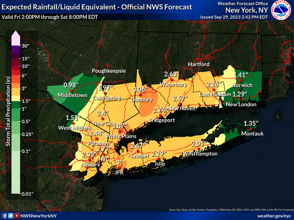
Mesoscale Precipitation Discussion 1112
NWS Weather Prediction Center College Park MD
1116 AM EDT Fri Sep 29 2023

Areas affected...far eastern PA into NJ, southern NY/Long Island,
CT and western MA

Concerning...Heavy rainfall...Flash flooding likely

Valid 291515Z - 292045Z

SUMMARY...Flash flooding will remain likely across the tri-state
region over the next few hours, some of which could be significant
to major. Rainfall rates of 1-3 in/hr and additional totals of 3-6
inches prior to 21Z should be expected, leading to a very
dangerous situation if these totals overlap with 3-6 inches of
rain which has already fallen over NYC.

DISCUSSION...1445Z regional radar imagery continued to show
widespread moderate to heavy rain across the NYC metro into
southern NY/western CT/western MA. The highest rainfall rates were
located just north of NYC into far western CT, along a low level
convergence axis forced by a mesoscale circulation over NYC.
Wunderground and NYC Mesonet/NYC Micronet gauge data has shown 3-6
inches of rain has fallen across the Five Boroughs with rainfall
rates peaking in the 2-3 in/hr range over Brooklyn around 12Z,
resulting in numerous flash flood impacts across the region. While
lightning observations have been largely absent, a few embedded
thunderstorms have been observed where elevated instability of a
few hundred J/kg was present, rooted near the 850 mb level via the
12Z OKX sounding. Precipitable water values were near 1.6 inches,
just above the 90th percentile for late September but despite the
somewhat modest moisture, forcing for ascent was strong...owing to
low level overrunning of an inverted surface trough which extended
northward from the northern Mid-Atlantic coast into far western
Long Island at 14Z. Low level winds centered near 850 mb were
averaging 20-30 kt from the SE, supporting multiple rounds of
heavy rain with recent redevelopment of heavier rain along and
offshore of Manmouth and Ocean counties in eastern NJ.

Pivoting of the 20-30 kt low level axis of winds to the north of
an 850 mb circulation centered over southern NJ is expected to
support the refocusing of heavy rain into portions of
central/northern NJ while southeasterly flow maintains areas of
heavy rain into southern NY and portions of western CT/MA, where
terrain influences will augment rainfall intensities. The
potential for 1-3 in/hr rates will remain with the higher end of
that range more likely over far eastern PA into NJ where
increasing instability into the early afternoon is expected with
continued low level moisture advection, allowing for MUCAPE values
in the vicinity of 500 J/kg. Flash flooding is likely to continue
across the region, with areas of major flash flooding likely where
overlap of additional heavy rain occurs with areas of ongoing
flash flooding with an additional totals of 3-6 inches expected in
some locations.
-
.70 here on the western fringe, this is one of those times I do not mind being fringed.
-
1
-
-
Stuck in/under the classic early fall Wallkill River valley fog
-
2
-
-
6 hours ago, IrishRob17 said:
1.95” and counting, 9.17” for the month.
54/52 with constant light rain, up to 2.33" for this event.
-
On 9/24/2023 at 6:52 AM, doncat said:
Astro summer here was wet with 19.09" of rain which is 6th highest in 42 years...last summer saw just 8.50 ".
My astro summer was 31.69" this year, last year it was 6.50".
June-Sept this year: 34.79" June-Sept 2011: 38.51"
-
4
-
-
1.95” and counting, 9.17” for the month.
-
 1
1
-
-
21 minutes ago, Stormlover74 said:
It's hard when you only have 10 men on the field
And apparently it was a right side linemen missing.
-
8 hours ago, Rjay said:
Same shit every year from Notre Dame.
So effin' close, last nights game goes right up there with the damn Bush Push game
-
.17 on the day
-
16 minutes ago, MJO812 said:
60s forecasted all next week
Beautiful
Getting close to hoodie weather
-
3
-
-
13 minutes ago, Brian5671 said:
Still is....
It’s a major award!
-
1 hour ago, Rjay said:
How many has metsfan won?
All I know is that CTblizz was a well deserved weenie of the decade on the old board.
-
1 hour ago, forkyfork said:
i have a 100% win record. cool
-
2
-
-
After the summer that we've had I can't be the only one to look at 2" of rain and say "meh". Of course the high water table trough doesn't need much to cause flooding issues.
-
2
-
-
27 minutes ago, nycwinter said:
i have seen many people wearing hoodies for the last few days now it is hoodie season!!
If they told you that wolverines would make good house pets would you believe them? Up to 64 under brilliant sunshine.
-
 1
1
-
-
6 minutes ago, MJO812 said:
I like hoodie weather
It's not here yet, high of 72 forecast here, 75 there, and plenty of sun.
-
2 minutes ago, MJO812 said:
60 here
Wearing pants and jacket this morning
A jacket at 60?! I thought you liked cool weather? Low of 54 here.
-
 1
1
-
1
-
-
Why can't I be a magnet for snow like I am rain this year, approaching 2.50 and still pouring.
-
1
-
-
15 minutes ago, TriPol said:
If this rain keeps up and we continue to get below average temps, we’re in for amazing fall foliage, the likes of which hasn’t been seen in a long time. Get your cameras ready!
All of the rain now will likely cause muted/washout colors this year, we'll see. 1.17" IMBY

September 2023
in New York City Metro
Posted
Another double digit rainfall month here with 10.52” in September, July had 13.95”.