stormy
-
Posts
2,008 -
Joined
-
Last visited
Content Type
Profiles
Blogs
Forums
American Weather
Media Demo
Store
Gallery
Everything posted by stormy
-
Yes, and that can be dangerous to those looking forward to a Nino wet winter. Which only happens 43% of the time in my locale.
-
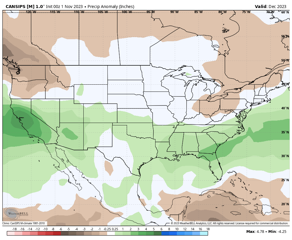
The latest CANSIPS paints that perfectly for December.
-
A little while ago I said that I would look at driest Nino winters since 1980 and snowfall for the Valley. The driest was 87-88 with 64% of normal precipitation (12.20"). I received 18 inches of snow which is 75% of normal snowfall for that winter.
- 1,295 replies
-
- 1
-

-
- wishcasting
- almost winter
- (and 1 more)
-
As I said Sunday morning, a few changes would give many in our region 4 - 8 inches of snow tomorrow. The NWS establishes a base of support with a WWA with the retreating cold air source and LP into the Ohio Valley. A terrible early season synoptic that chirps. https://forecast.weather.gov/showsigwx.php?warnzone=VAZ025&warncounty=VAC015&firewxzone=VAZ025&local_place1=4 Miles SSE Churchville VA&product1=Winter+Weather+Advisory&lat=38.1779&lon=-79.1425
-
22 degrees at 6 am.
-
Only a few changes would give us snow on Tuesday. Place that New Hampshire high over Superior. Track the Arkansas low to southeasterrn N.C. instead of southern Ohio. Presto, 4-8 inches of snow.
-
I received 4 inches on Thanksgiving eve in 1989.
-
You're a smart person!
-
I think your right..................... I'll take it no matter where it came from!!!! Of course, I'll believe it when its in the gauge.
- 1,295 replies
-
- 1
-
-
- wishcasting
- almost winter
- (and 1 more)
-
Last Wednesday at 5:41 pm I said in this thread that I sensed the atmosphere was beginning to feel El Nino and moisture influx into our area would improve over the next 5 - 15 days. The latest CPC thoughts give Virginia especially southwest of D.C. 2 inches of rain Tuesday/Wednesday. The latest 18z deterministic GFS gives my area through D.C. 2 - 3 inches during this time-frame. Was my call 3 days ago blind luck or divine intervention??
- 1,295 replies
-
- 3
-

-
-
- wishcasting
- almost winter
- (and 1 more)
-
You need a Cyclone Rake! Mine makes short work of leaves and holds 44 bushels before you have to dump. Price is reasonable for the work they do. Several sizes ranging from $1500 - $2000.
-
Wow!!! That was an hilarious blast!!!!!!!!!!!!!!!!!!
-
I am sensing that the atmosphere is beginning to feel El Nino.. The suppressed southeast system will steal moisture from Friday's potential as a little more northward influence allows greater stealing capability but this may be a positive signal for 5 - 15 days into the future. I predict that moisture influx will improve over the tristate region beginning next week just in time for my month ago Thanksgiving predicted beginning Nino influence.
- 1,295 replies
-
- 1
-
-
- wishcasting
- almost winter
- (and 1 more)
-
Suppressed southeast low pressure robs the moisture from Friday night frontal. 18z NAM12 now zero. Only 14% of normal first half of November at .24". Will do a study of nino winter snowfalls with less than 50% of normal precipitation. It will be bleak.
-
Spire is ok for a global impression, but I lost interest a few months ago because regional detail does not exist.
-
Congratulations on being gloriously positive! I assume IAD at 43 is a max.. I am usually similar to Dulles. That's right in line with my max. of 40 for Augusta.
-
This map is not "slightly to well below normal" for the 81-corridor. 22-30 inches can actually be slightly above normal. As far as Canaan, they border on 36" +. which is infinity. I'm like PSU, I can see 10 - 50 inches. Current repetitive Sahara like precip. patterns suggest 10 inches but I have high hopes for a pattern change.
-
Lynchburg 13.5 inches
-
It was amazing to see the deterministic GFS and GEM collapse from more than an inch on Friday 24 hrs. ago to nada at 6 am.. The ensembles held their own from yesterday as well as the NBM.
-
This would be workable. Trough in Honolulu, Ridge in Vegas, Trough in D.C.. Of course, considering the flip in 24 hrs., what will we have tomorrow??
-
Thanks for your interest Rodney. Lynchburg is considerably more inland. Though low elevation Lynchburg averages 12 inches of snow annually. Salisbury only averages 7 inches. Strong noreasters can wallop Salisbury more than Lynchburg. The nod for this winter goes to Lynchburg at 12 - 15 inches and Salisbury 9 - 12 inches.
-
BWI 19.1" DCA 14.3" IAD 25.8" RIC 8.2"
-
Here's the map:


-
Latest CPC analysis says 3.4 is now 1.80 with the DYN AVG now 2.0 thru Jan.
-
We need that deep trough well to the west with ridging over Nevada and troughing over the east with the axis over Nashville.