stormy
-
Posts
1,991 -
Joined
-
Last visited
Content Type
Profiles
Blogs
Forums
American Weather
Media Demo
Store
Gallery
Everything posted by stormy
-
Hello out west! I'm well aware of what you say. The HRRR brings the 850 freezing line to the west city limits of Staunton at 11 am, backs it up to Todd Lake at noon then Reddish Knob at 1 pm. Good luck! I'm reporting obs. 33.1 degrees w/ Lt.rain
-
This tells the story:
-
Arkansas stole the 850's
-
The Euro is out to lunch. 00z gave me 4.4 inches, the 06z gives me 2.5". 7:32 and I have 32.7 with light rain.
-
33 and dropping like a rock in Augusta County.
-
The cold HP has dived southeast and offshore of Virginia, setting up this southerly flow. That would have killed our chances in 1964 or 2024.
-
We used to be a snow town but Spruce and Snowshoe have gotten greedy in recent years since the Atlantic has divorced us.
-
I'm much warmer down here in Augusta at 40.
-
Increasing threat of freezing rain adding another element to this system for west of the BR in the Central Valley. 2 inches of snow/sleet with up to .50" freezing rain.
-
I hope you're right!! But it will take another 8 inches of rain. (soaking steady rain)
-
Its a sign of the times. 25 years ago we didn't engage in this lunacy. I know because I was in the business.
-
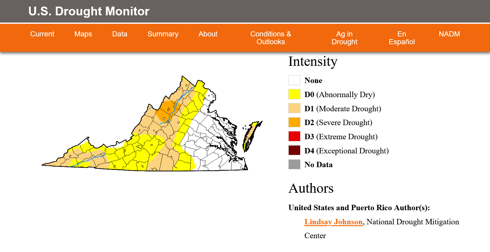
Dear God! We cannot get out of Severe Drought!!!!!!

-
I understand the 36 hr. timeframe guidance. But 50% confidence in meeting warning criteria?? The deterministic ECM is the only model minimally meeting warning criteria for most of Augusta and no model does for Nelson or Albermarle. GFS 2.5", GEM 1.3", NAM 1.5". But, as you say, they can always downgrade to an Advisory and they will unless a radical change occurs with the models.
-
From 00z to 12z, most of the models settled into a 1 - 3 inch special west of the Blue Ridge in the Central Valley. All except the Euro. It increased my snow from 2.6" to 5 inches! The EPS increased from 3.1 to 4.3. It has increased the qp from .48" to .72" but the borderline 850 and 925 is playing hopscotch all over the place. My forecast west of the BR is 2 - 4". For D.C. proper, a trace to 1 inch.
-
Ice is becoming more of a concern this morning in Augusta County. My 3 model blend for 10:1 snow is still 5 inches but now up to .40" FR and 1 inch of sleet.
-
An observation tells me we are still in the game for Saturday though some are giving up. 24 hours ago my 3 model blend for Augusta was 7 inches. Now, that same GFS, ECM and GEM blend is 7.3 inches. As I said 24 hours ago.................. These models will hone in on a solution by tomorrow afternoon. It will not be a human solution, it will be the models.
-
That should be "primary highways".................... Only secondaries are "roads"..... education is priceless.
-
18 z GFS focuses heavier qp to inland areas. That makes the difference with snowfall totals.
-
18z GFS increases my Augusta snow from 5.4 to 9.1 inches
-
Jan Medium/Long Range Disco: Winter is coming
stormy replied to stormtracker's topic in Mid Atlantic
That's exactly what I need to clean my stream out! It has been 2 years. -
Hmmm...... Saturday and Tuesday are now nearly tied!! 7.5" on Saturday and 6.9" on Tuesday. 10:1 GFS, ECM, GEM deterministic. Ensembles 3.8" Saturday, 4.5" Tuesday
-
This will likely be the first real winter storm for the Valley since Jan. 16, 2022 when 8.5 inches fell.
-
18z GFS doubles my snow from 5 to 10 inches. The front end thump is intense with the 18z.
-
If the trailing wave becomes the storm would that push the height of the storm into Sunday?
-
I smelled a rat 24 hours ago when I said the GEM was beginning to focus on what the EURO was only sniffing at. Now, the GFS, GEM aand ECM all sense potential significant flaws with the idea of a major winter storm. Thermals are a problem and this system seems to be losing the ability to really crank! The GFS has cut the qp in half for my area and dropped the snow from 14 to 5" in one run. The ECM drops from 12 to 8 ", but the GEM increases from 2 - 8". This can still be a beast if the coastal bombs over Va. Beach and additional cold air is wrapped in from the north. I believe the models will hone in on a solution by Thursday afternoon.