

Brian5671
-
Posts
42,243 -
Joined
-
Last visited
Content Type
Profiles
Blogs
Forums
American Weather
Media Demo
Store
Gallery
Posts posted by Brian5671
-
-
12 minutes ago, PB-99 said:
Did you bother to look at the surface map ?
It`s in the 20`s in NYC at hour 216
on the canadian? No it's in the 40's (edit-sorry I thought this was the CMC you were referencing-did not see the euro)

-
Just now, Ericjcrash said:
Yeah, not gonna work

No cold air. (road trip to Maine?)
-
2 minutes ago, winterwx21 said:
That certainly was an ugly 12z GFS run for long range. A shame that what looked like a flip to a sustained cold pattern about a week ago completely fell apart in the last few days. Long range is so difficult to predict. Thank goodness chances are increasing that we'll pick up a few inches of snow here on saturday. It looks like our last snow threat for quite awhile. Hopefully February will be good like some of the signs are pointing to.
Boring run for sure-granted after day 6 it's all fantasy but it has 2 cutters the entire run after this weekend's cutter. At least give us an exciting Southeaster or something....
-
1 minute ago, Snow88 said:
Great sign
The euro and gfs has been playing catchup all winter with the mjo.
Too many other things to fix IMO. We will certainly see some snow chances but if you read Iso's update, there's not much to get excited about if you're looking for anything cold/snowy sustained pattern
-
2 minutes ago, Allsnow said:
The mjo the last two years has been incredibly frustrating. All we do well with it is amplitude in the warm phases. And when we do get favorable phases (ex feb 2019 and January 2020) we don’t get the response we are expecting. For some reason the mjo in cold phases during November has worked better lol.
Admittedly, I didn’t see how bad the pv was going to hurt us this winter. Once it continued to strengthen and couple with the atmosphere it was lights out.
completely agree. Seems like nothing wants to work out this year....no help anywhere
-
 1
1
-
-
4 minutes ago, SnoSki14 said:
Doesn't look like it'll enter 8 though. Seems it goes through 7 and dies off in circle or stay in 6/7 at very low amplitudes.
COD or low amplitude 4/5/6 could be ok-any amplitude in the warm phases and we'll torch like the 1st half of the month
-
1
-
 1
1
-
-
-PNA and SE ridge sounds like more cutters or at best snow to rain as noted in the outlook. (and any cold to dump out west or best case midwest)
-
4 minutes ago, doncat said:
Not only mild this month but quiet too... Even with this upcoming event, not a lot of precip... Will put most stations near an inch for the month so far and not much showing up in the medium to long range, as of now.
Reminds be a bit of Jan 2002 and Jan 2012-a very warm dry month with one moderate snow event around 1/20 (which was the biggest of the winter both times)
-
13 minutes ago, Eduardo said:
Last year, I finished with a single-digit snow total. Today is the first time I fear that may repeat itself. Looking pretty ugly moving forward.
OP models are a joke after 5-6 days, but it's amazing to see them with zero snow for us for the entirety of the run after this weekend. Not even a 384 hr fantasy blizzard
-
Brutal out there with the wind today-19 degrees with 35mph gusts
-
13 minutes ago, SnoSki14 said:
Yeah everytime there's promise it keeps getting pulled back.
Even the current cold shot is much less severe than initially expected and then we're back in the 40s and 50s next week.
I should've stuck with my late Feb to March winter comeback prediction because so far everything has gone just as bad as last season (worse in fact).
It's not all that different from last year. (it's actually warmer) The same issues exist. Locked in poor pattern with no sign of an end
-
15 minutes ago, Snow88 said:
Long range forecasts shouldnt be predicted anymore. Everyone was getting excited about a possible pattern change at the end of this month because of a pattern modeled over 240 hours out.
Like Bluewave said-the 11-15 day range is not all that accurate, it gets more play these days with the rise of social media.
-
1
-
-
Need a wholesale pattern reshuffle...not sure that's in the cards this year-Strong PV over the pole, No Atlantic help, Pacific is terrible and we have a strong PAC jet. I'm sure we'll see cooldowns like we're having now and maybe a minor to moderate snow event here and there (hopefully), but I think it's about time to toss in the towel for anything sustained for a while.
-
4
-
-
50 minutes ago, forkyfork said:
13 pages for 1-2"

something better to talk about?
-
1
-
1
-
-
Good post by Ryan Maue about the pile of garbage models have been this winter:
I'm taking even more interest in Weekly weather forecasting since much of it lately is awful. Forecasters have strong biases that aren't rectified leading to repeated busts. So, is winter canceled or not? -
5 minutes ago, Allsnow said:
Yep. That’s not a good look in the 11-15 day. The goa low would move into ak. Let’s hope that’s not correct. We have seen the 11-15 day just change.
we can live without a -NAO or even AO but a +EPO with those 2 will just be more of the same
-
2
-
-
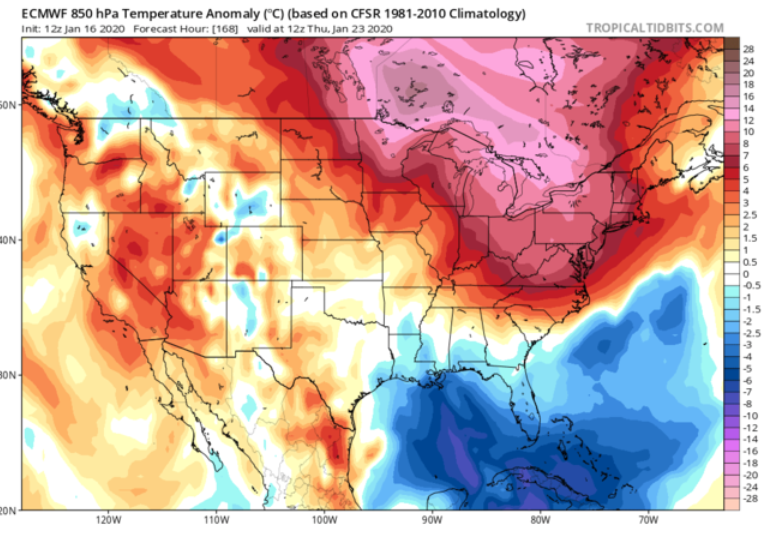
20 minutes ago, PB-99 said:
The 850s ?
5 minutes ago, PB-99 said:Jan 20 - 21 -22 are all BN and spend most of the 3 day period in the 20`s to low 30`s.
So yes that`s a change.
The warmest the actual 850`s get in the Northeast on the EPS post Jan 20 at hour 204 in plus 3. ( That`s not April ) .
The anomalies show up like it`s a torch, because like I said you can`t use anomalies in late Jan, because they are cold so any AN " looks warm " but the actual surface is plus 5 for 3 days and that`s not cold.
Unfortunately it is day 9 - 11 as the ridge hangs down off H/B. ( so that may blow the day 10 system ) .
By day 12 the ridge retracts over H/B and the S branch is sending impulses out.
That`s what the EPS shows today - I don`t think that sucks, but if you do , have at it.
it sucks for snow around here and that's what most will care about. A day 10 rainstorm amidst a few colder days (and let's be honest this cold is nothing to write home about) is nothing to get excited about. Sorry. Last January's cold, although fleeting (nothing to block it in) was much more impressive.
-
 1
1
-
 1
1
-
-
4 minutes ago, nycwinter said:
20;5 inches....
Yep, figured that. Time to root for a Feb 06 redux-that would take care of the 20 inch problem.
-
Just now, nycwinter said:
since 2008-2009 winter.. we have had over 20 inches in central park except for the 2011-2012 winter season..
what was last year? Had to be very close to 20 then.
-
couple snow showers here with temps around 45-47
-
As someone said, if it doesn't change by the end of January it probably won't.
-
2 minutes ago, frankdp23 said:
the next day looks even...redder, lol. We will see what happens. Seems like a large change
Ouch. If we can't hold onto the cold beyond a few days, we're in trouble (and even the cold next few days into early next week is not anything that's crazy for Jan) Last Jan had some short lived but much more impressive cold.
-
1
-
-
Just now, frankdp23 said:
Christ. That won't bring anything wintry....
-
1 minute ago, CPcantmeasuresnow said:
We shall see.
Dec 2006 was 43.6 but December 2015 was an unprecedented 50.8 which was close to the average temperature for April.
January 2007 was 37.5, so far this January is 42.7.
I'd call it a draw right now.
what's impressive is that Dec '19 had a cold first 3 weeks, so most of the warmth was in 4 weeks....

January 2020 General Discussions & Observations Thread
in New York City Metro
Posted
that's not great either-awesome track yet's it's rain back to JB....