LakePaste25
-
Posts
1,351 -
Joined
-
Last visited
Content Type
Profiles
Blogs
Forums
American Weather
Media Demo
Store
Gallery
Everything posted by LakePaste25
-

2026-2027 Record-breaking El Nino
LakePaste25 replied to Stormchaserchuck1's topic in Weather Forecasting and Discussion
-
2026-2027 Record-breaking El Nino
LakePaste25 replied to Stormchaserchuck1's topic in Weather Forecasting and Discussion
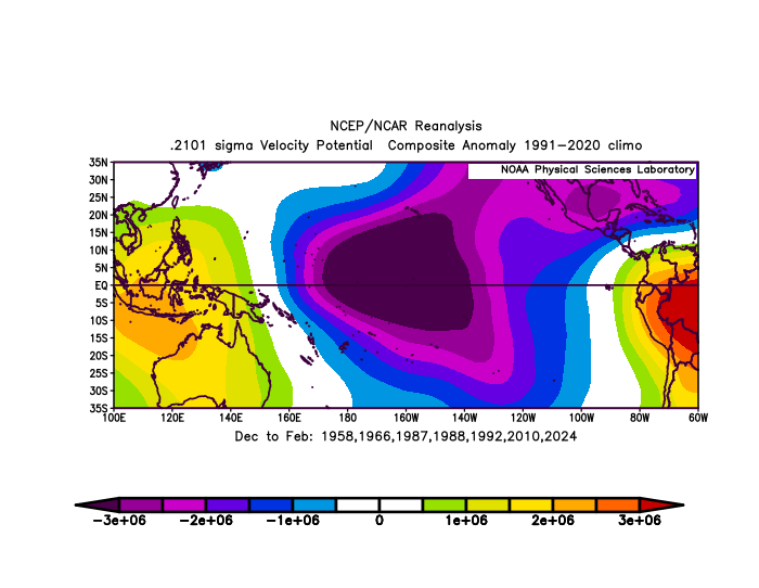
I converted these to VP anomalies. Basically the intense composite has stronger subsidence over the MC while the strong composite has stronger subsidence over S America. Makes sense.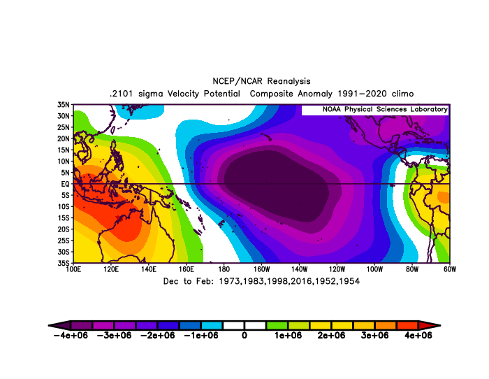
-
2026-2027 Record-breaking El Nino
LakePaste25 replied to Stormchaserchuck1's topic in Weather Forecasting and Discussion
It’s basically a lower % of modoki forcing, so the SE US is NN instead of blue in the seasonal mean. -
2026-2027 Record-breaking El Nino
LakePaste25 replied to Stormchaserchuck1's topic in Weather Forecasting and Discussion
yeah they’re not “cooling” by a full 2.05C from Dec to March. the seasonal climatological mean is also increasing. -
2026-2027 Record-breaking El Nino
LakePaste25 replied to Stormchaserchuck1's topic in Weather Forecasting and Discussion
Yeah plus I think it’s likely to give us a better decade. Warm pool will recover somewhat after this year for sure, but we’re also removing a lot of ocean heat content this way, and it won’t be such an extreme gradient. -
2026-2027 Record-breaking El Nino
LakePaste25 replied to Stormchaserchuck1's topic in Weather Forecasting and Discussion
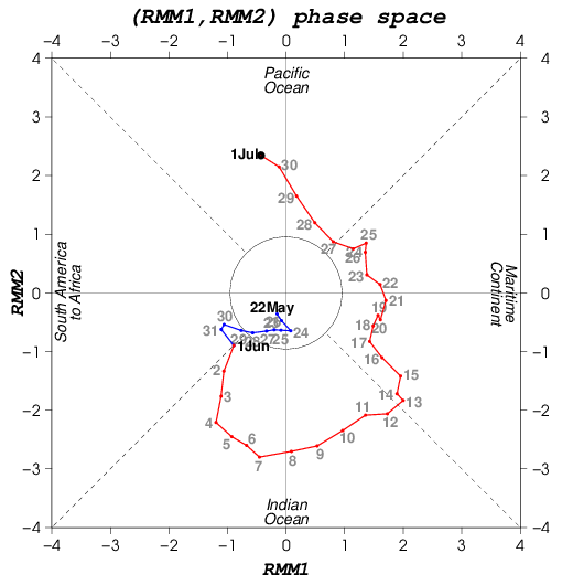
As opposed to 2015, where it was either in the COD or 4-5-6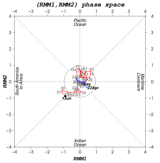
-
2026-2027 Record-breaking El Nino
LakePaste25 replied to Stormchaserchuck1's topic in Weather Forecasting and Discussion
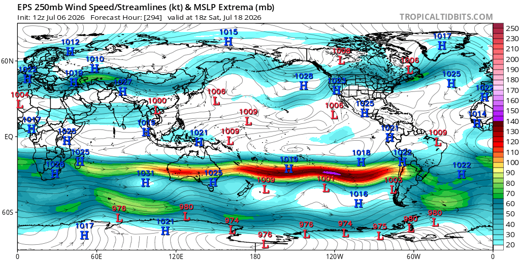
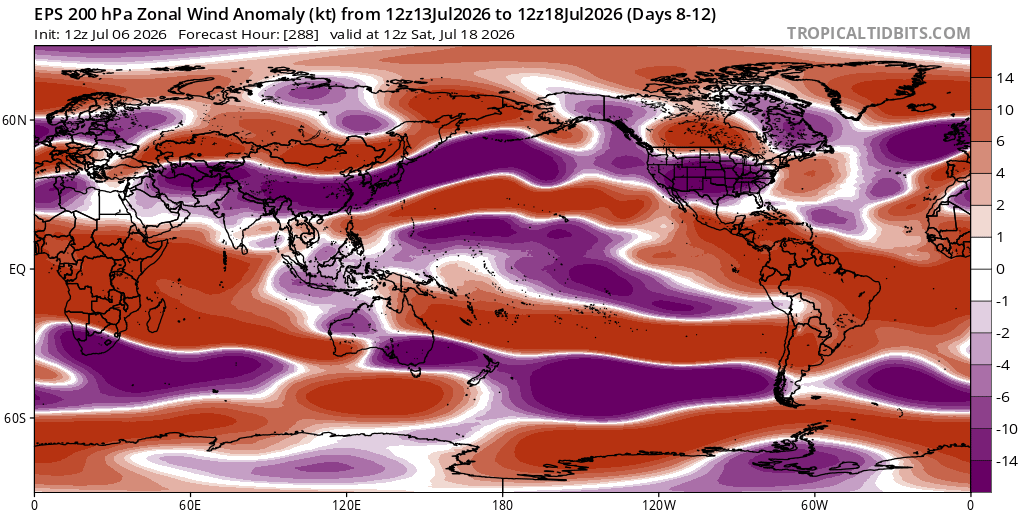
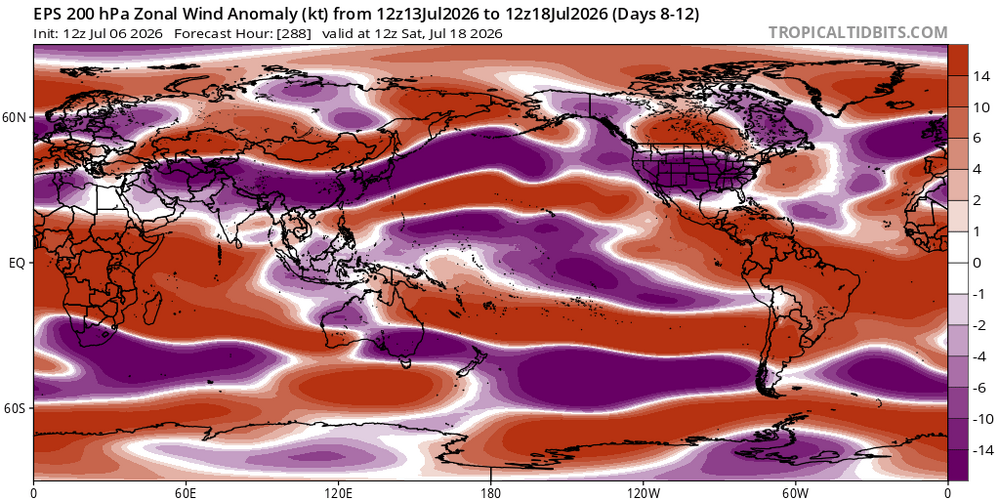
Here’s the SH the pac jet extension and +U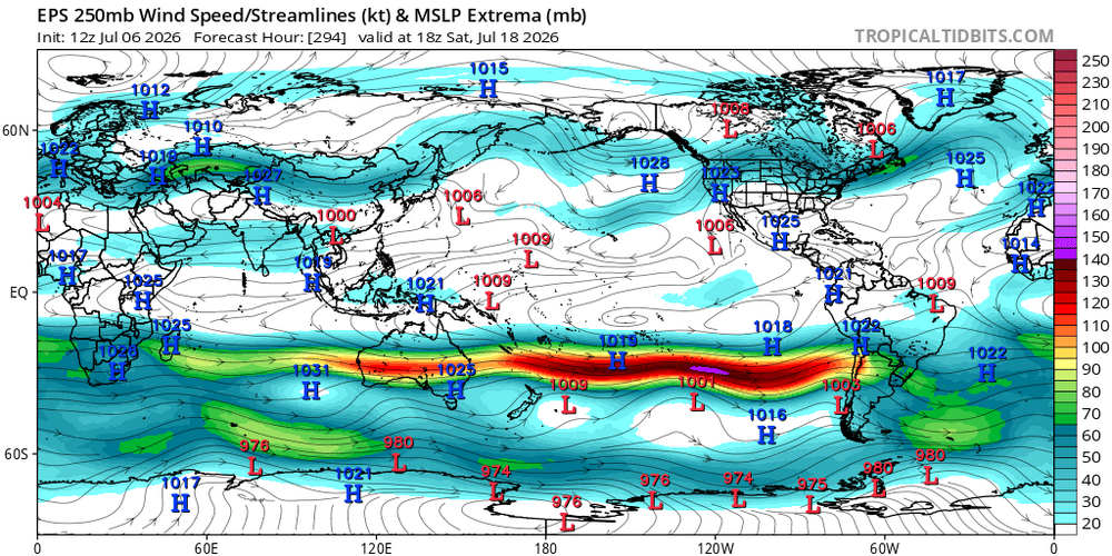
-
2026-2027 Record-breaking El Nino
LakePaste25 replied to Stormchaserchuck1's topic in Weather Forecasting and Discussion
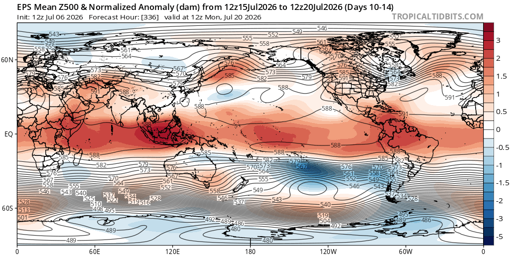
EPS has this really getting going in the extended: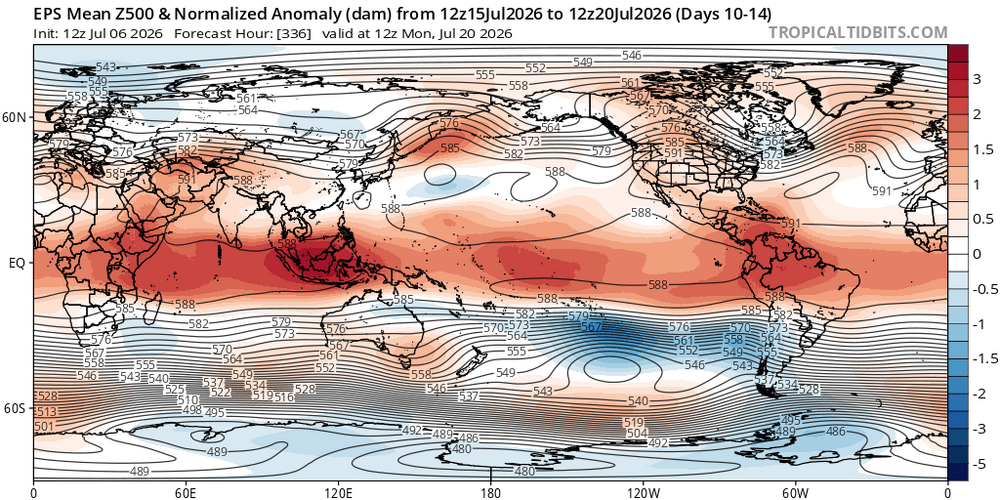
-
2026-2027 Record-breaking El Nino
LakePaste25 replied to Stormchaserchuck1's topic in Weather Forecasting and Discussion
@snowman19 -
2026-2027 Record-breaking El Nino
LakePaste25 replied to Stormchaserchuck1's topic in Weather Forecasting and Discussion
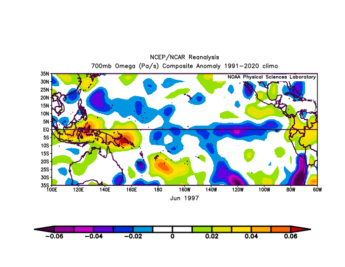
The problem with using 91-2020 climo for those years is everything is mostly blue and it’s tough to pick out key features. -
2026-2027 Record-breaking El Nino
LakePaste25 replied to Stormchaserchuck1's topic in Weather Forecasting and Discussion
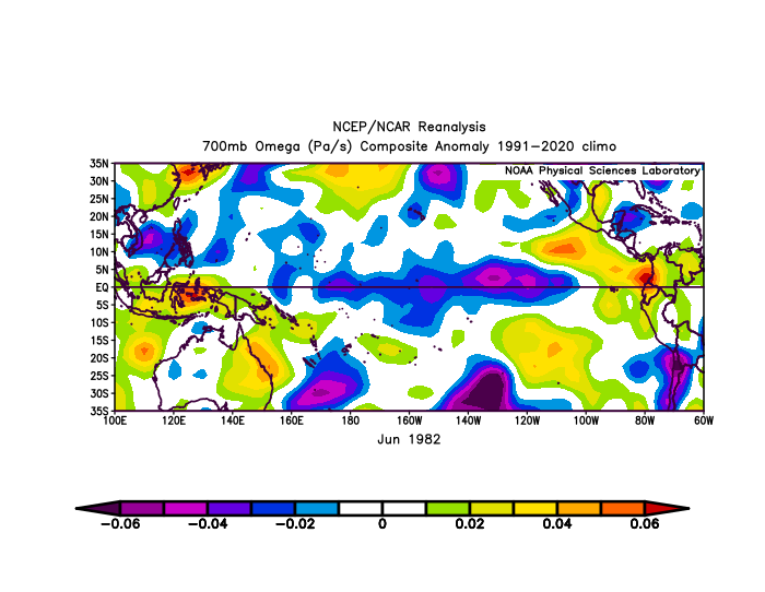
Anyone have June 2026 omega? Would like to compare it to the previous super events but NCAR was eliminated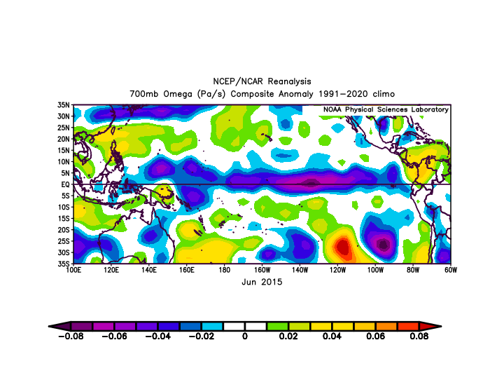
-
2026-2027 Record-breaking El Nino
LakePaste25 replied to Stormchaserchuck1's topic in Weather Forecasting and Discussion
Just to expand on this, I think 66-70% unfavorable/30-34% favorable is probably the absolute ceiling for this event in terms of best-case scenarios, which equates to 1 good winter month out of the 3. 50/50 or unfavorable 30%, 70% favorable you’re getting into Modoki territory and there’s simply no support for that kind of event. -
2026-2027 Record-breaking El Nino
LakePaste25 replied to Stormchaserchuck1's topic in Weather Forecasting and Discussion
Yup. Avoiding absolutisms (such as “this will be a wall-to-wall shutout, record low snow, etc.”) is key to seasonal forecasting. There will be pacific jet extensions and it will be unfavorable for winter far, far more often than not. Probably as high as 70/30 or 80/20 unfavorable. But there should be some windows of opportunity, even if brief. Of course I am more of a weather weenie than just a snow weenie, so even seeing coastals and severe outbreaks in the South will keep my interest going, plus tracking those brief opportunists to see if a KU event comes to fruition will also be fun. -
2026-2027 Record-breaking El Nino
LakePaste25 replied to Stormchaserchuck1's topic in Weather Forecasting and Discussion
I could see the euro seasonal close to being accurate if we see a full discharge of the W pac warm pool and muted MC forcing. This is probably why the Euro plumes are also showing ONI of +3C to +4C. These go hand in hand IMO (warm pool discharge and record breaking Nino). -
2026-2027 Record-breaking El Nino
LakePaste25 replied to Stormchaserchuck1's topic in Weather Forecasting and Discussion
While it won’t be a wall to wall shutout and there will be cold shots & brief opportunities, I would expect a pac jet dominated winter. -
2026-2027 Record-breaking El Nino
LakePaste25 replied to Stormchaserchuck1's topic in Weather Forecasting and Discussion
yuck. I like some summer heat so i’m genuinely glad I don’t need to endure the summers of the 70s and 80s Ninos. 50s in late june sounds awful. -
2026-2027 Record-breaking El Nino
LakePaste25 replied to Stormchaserchuck1's topic in Weather Forecasting and Discussion
Martz is a fraud and routinely posts wrong information/data to spin a narrative. Berardelli is also wrong about the heat coming from the Nino -
2026-2027 Record-breaking El Nino
LakePaste25 replied to Stormchaserchuck1's topic in Weather Forecasting and Discussion
Not even disagreeing with you or claiming you’re wrong just putting different theories out there -
2026-2027 Record-breaking El Nino
LakePaste25 replied to Stormchaserchuck1's topic in Weather Forecasting and Discussion
Still fairly weak correlations (compared to winter). I think the +AO/+NAO is a bigger contributor to all of this mid latitude heat rather than a non-coupled Nino response (it’s coupled). I don’t think we’ve seen this lack of high latitude blocking in previous super Nino summers and it may not be related to how the Nino itself is developing. Could be something else going on here entirely. -
2026-2027 Record-breaking El Nino
LakePaste25 replied to Stormchaserchuck1's topic in Weather Forecasting and Discussion
I think the sample size for pre-super Nino summers is simply too small. That rockies ridge is definitely coming from central pacific forcing. -
2026-2027 Record-breaking El Nino
LakePaste25 replied to Stormchaserchuck1's topic in Weather Forecasting and Discussion
Eric Webb thinks it’ll be more east based than 15-16 but not as east as 97-98 FWIW. -
2026-2027 Record-breaking El Nino
LakePaste25 replied to Stormchaserchuck1's topic in Weather Forecasting and Discussion
I think csnavy was hoping for a moderate Nino earlier this year before it was obvious that there wasn’t going to be? Don’t think snowstorm is being inferred here. Nobody can say whether there will be one or not -
2026-2027 Record-breaking El Nino
LakePaste25 replied to Stormchaserchuck1's topic in Weather Forecasting and Discussion
maybe let’s get through this season before talking about *next year’s* La Niña again? i’m hardly ready to even talk about this coming winter yet although that is tough to avoid because it’s talked about daily here -
2026-2027 Record-breaking El Nino
LakePaste25 replied to Stormchaserchuck1's topic in Weather Forecasting and Discussion
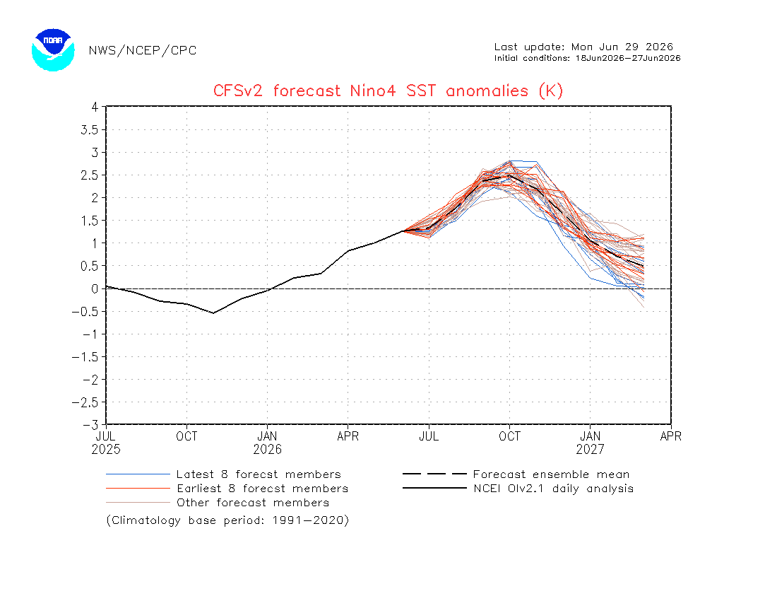
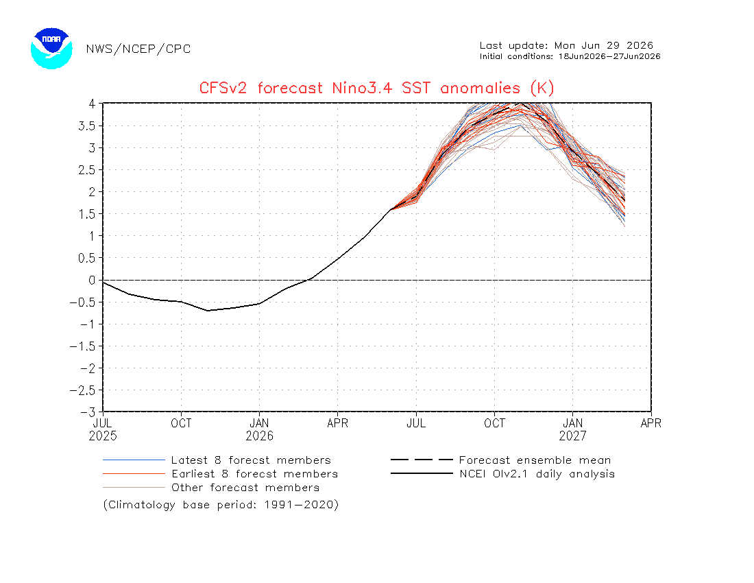
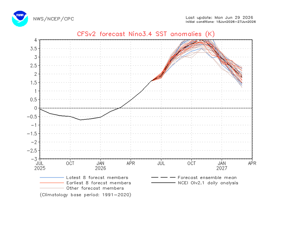
Latest CFSv2 is more indicative of a basin-wide event. Have to keep an open mind here because I think basin-wide is def on the table (not just east-based).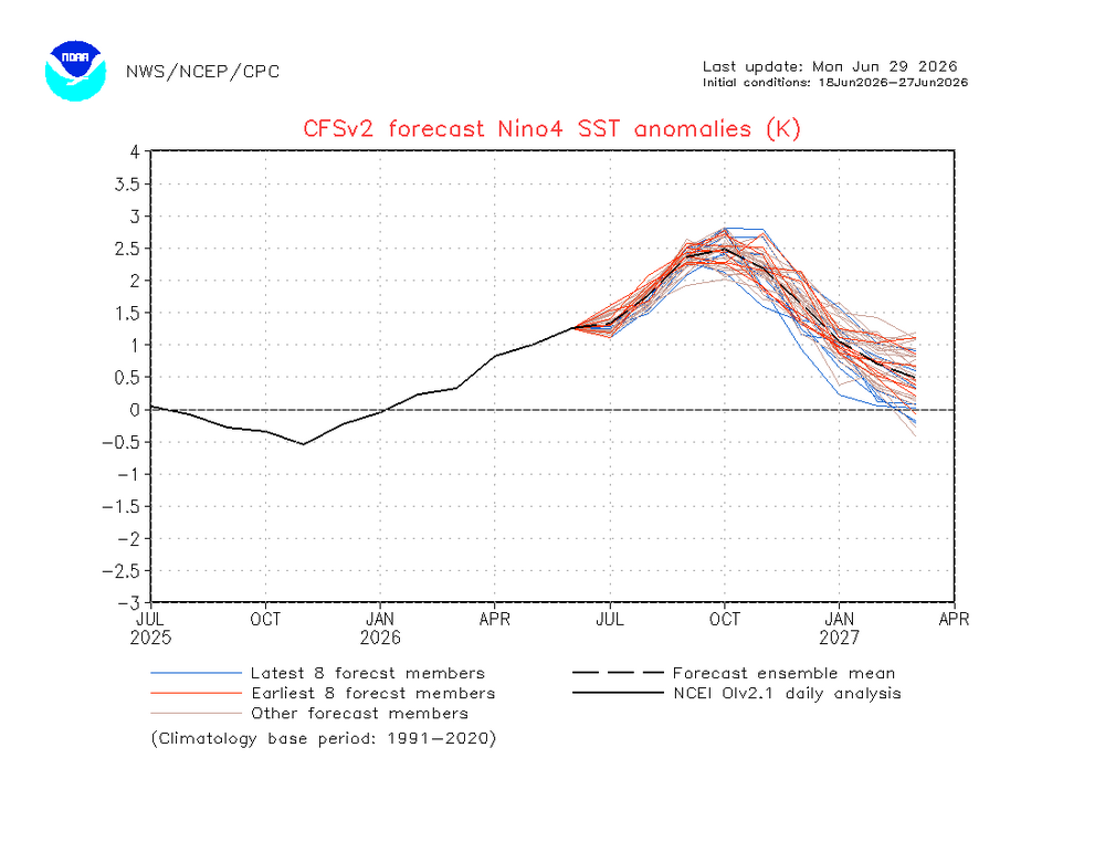
-
2026-2027 Record-breaking El Nino
LakePaste25 replied to Stormchaserchuck1's topic in Weather Forecasting and Discussion
But how much warmth can we say is because of “unusually strong MC forcing for a Nino”and not plain climate change? Every ridge these days seems to be record breaking. It’s not like it was 65-70 every day during the previous super Ninos - we had warmups during those too, but since we had a much cooler baseline, they did not set records. I just don’t think we can default to blaming the MC every time or pretend that MC forcing never existed at all during Ninos back then. This developing Nino also seems to lack a -NAO but since our sample size is pretty small it may be less correlated to begin with. I’ll agree that if this winter we see some major P4-6 activity like we did in 15-16 again then something is up. I’m just not ready to say it’s a permanent feature.