.jpeg.302c67143ea75c332053973bc310ec90.jpeg)
kazimirkai
-
Posts
174 -
Joined
-
Last visited
Content Type
Profiles
Blogs
Forums
American Weather
Media Demo
Store
Gallery
Everything posted by kazimirkai
-
Ill take it November 2018 and December 2019 are anomalies then?
-
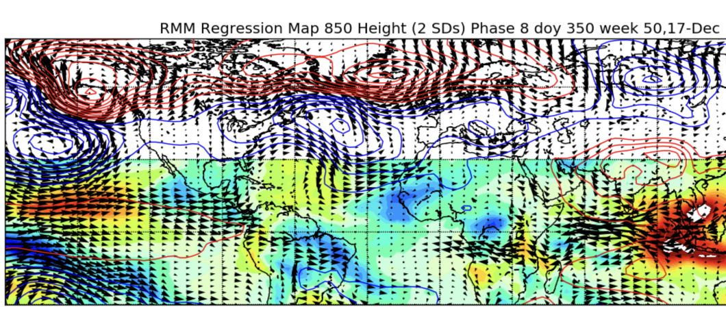
That's an improvement on the euro since yesterday, OLR mins closer to the dateline and all. Here's a semblance of what that transition might look like. Pretty hard to get those strong westerlies in the phase 8 map with la niña easterlies so we'll see how they contend. Id be surprised if the MJO stayes in 8 for long but we'll see if there's some constructive interference with easterly eq. rossby to prolong convection in the region a bit. That would be best cast scenario

-
It does seem like this event is increasingly projected to pretty quickly rebound by mid month Dec. We'll see if the MJO has anything up its sleeve regarding a 2000 situation
-
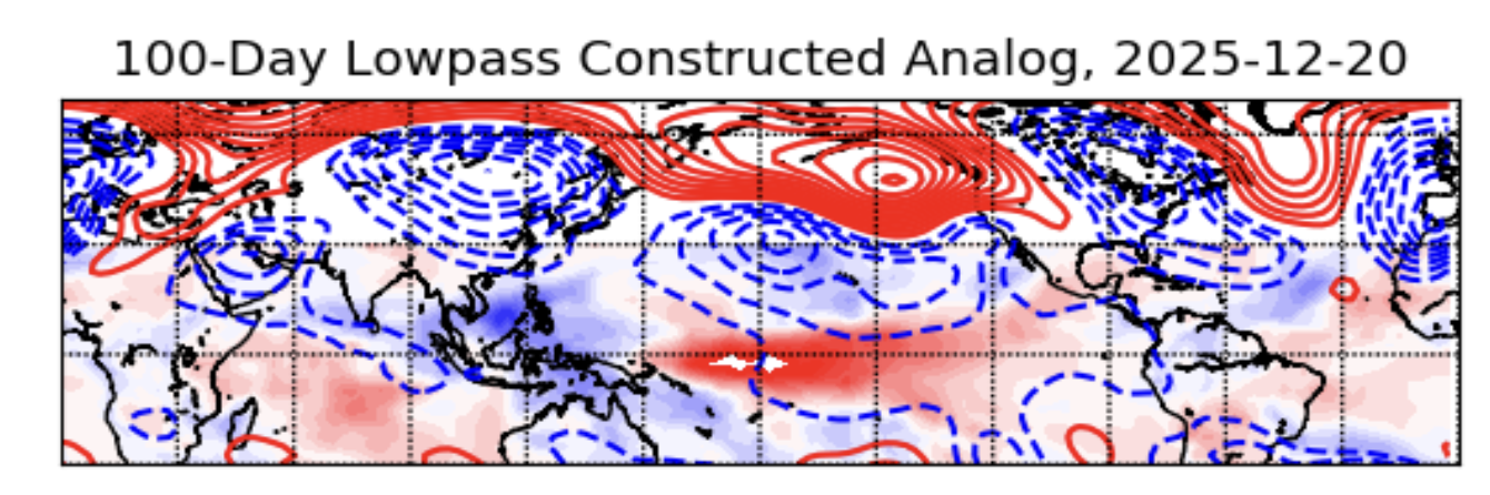
Well the low-frequency background state shows low heights in the east during the time period where MJO is most likely not projecting so the pattern is likely to stay generally seasonal. I wouldn't expect a massive warmup or anything but more of a moderation

-
Yeah my professor was highlighting the off-the-scale wind anomaly within the last few days. He does think that the MJO will wrap back around before reaching 8 and usher in a more central US trough for the latter part of December. Fairly confident that the beginning will be cold though.
-
Pretty uncommon for short-range oscillations like the PNA to remain strongly in either state for a whole month. I wouldn't put too much weight on this negative flip, though it might explain the great lakes track that seems more likely during the latter half of nov. and perhaps during the first week of dec.
-
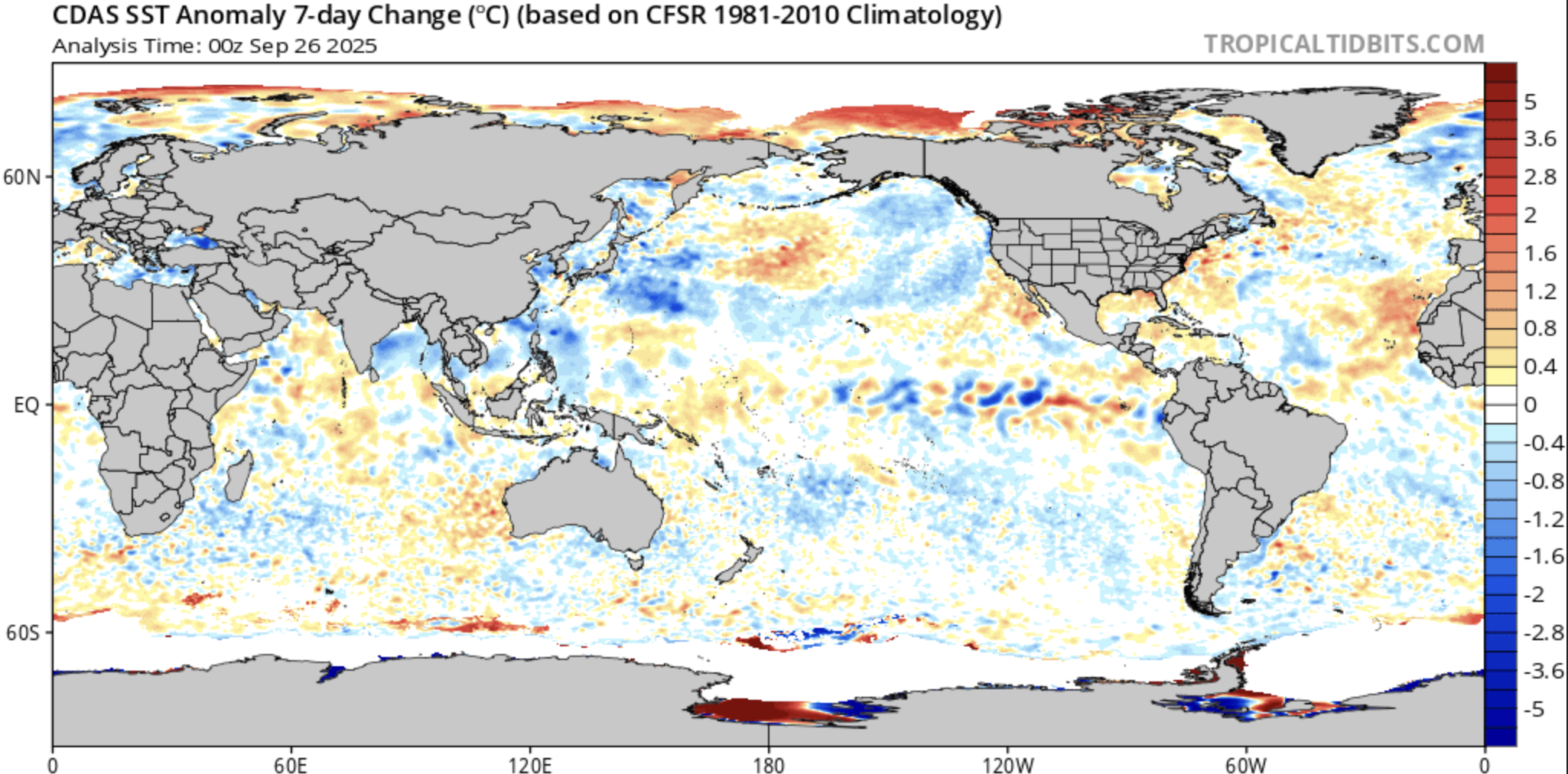
Warm waters into the W pac. from this westerly wind burst are priming the ENSO for a real shift come the next big event.
-
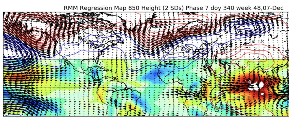
This seems reasonable. I think this early December cold wave is mainly driven by high frequency signals, mainly the 7 phase MJO, but i think its too early for the SSW to be having any impact. Roundy thinks there will be some warmth in late December as the MJO move back towards 1 and 2 (abeit prolonged due to an easterly eq. Rossby wave continuing convection in region 7), but it seems like it may have a weaker signal at that point so influences from things like the SSW on top of the low-frequency state (troughy in the east) would lead so something like this.
-
I'll ask him about it tomorrow. The tool hes using is his own lowpass filter, which he's mentioned is only one of many metrics to refer to, identifying the base state, from which higher-frequency signals like the MJO superimpose on top of when they're stronger. He has been serious about the RMM forecasts lately though. We go over the recent runs at the beginning of each class.
-
Thanks! This will come in handy
-
Do any of you who may be more professionally informed on meteorology know good ways to find private sector work in the industry or seasonal forecasting work? I'm in grad school right now looking around and it's tough to find some of the less advertised employment. What are your experiences?
-
I mean that type of pattern just seems like the ordinary climatology for the coastal northeast (ie. only one month out of the three is consistently cold and snowy). Barring some anomalously cold and stormy periods in the little ice age, 1880s, 60s, 90s, late 2000-2010s, it's not historically typical in this part of the world for it to be real cold through the whole winter. At least according to Kocin and Unccelini, the characteristic of sporadic moderate (>4") to heavy (>10") snowstorms punctuated by periods of mild temperatures and dry ground is the norm. This doesn't have all that much to do with this post but I just wanted to point it out cus I'm tired of seeing people dissapointed by "remarkably unwintry" seasons and periods that aren't really all that remarkable considering larger climatologies. There are near 10-year stretches in the late 20s/early 30s, late 40s/early 50s, early 70s where the average annual snowfall across the northeast corridor from DC to Portland was hardly above 25". I've been reading accounts from the revolutionary war of the same "inch of snow transitioning to slush and cold rain" type weather in January that everyone complains about nowadays. This current period is a particularly severe bout, exacerbated by cc, but shouldn't be all that shocking. The NE corridor just isn't rly that cold.
-
* Ahem* don't mind the record rainfall that Albany and southern NY received the day after this data in this map was valid
-
Well I think he was implying that it formed as a result of the event rather than necessarily during it. His name is Paul Roundy and has a lot of neat papers on seasonal climatology fyi. I can ask about the details next class if you want, don't fully know myself tbh.
-
How much are we expecting the NE pac to cool over the next few months? My seasonal/subseasonal prof is saying the NE warm pool is a remnant of the triple dip and wont last much longer

-
Typically has a cold bias though so the consistency in warm/dry anomalies it's been progging for early season over the past couple days may be worth noting
-
How can the ENSO cool and La niña composites have completely opposing temperature anomalies in the eastern US? The temperature of the tropics can't have been that different in these two scenarios, why would its effect suddenly reverse?
-
Do any of you guys have experience/tips with the wxprediction.com subseasonal forecast contest?
-
Yeah, it's a really great time to be a winter weather fan just entering the industry
-
Is Saharan dust/dry air not included in this factor list because of its difficulty to forecast long term? It seems like that's been a significant limiting factor for many storms in the past few years, especially in the early season
-
How do you forecast PNA and NAO so far ahead? Are you just running on analogs?
-
How can you be sure of the reliable influence of any teleconnection these days if they can just be nullified by some unseen pattern against all prior correlations?
-
We need a terrestrial theory of everything
-
I don't understand the value in using a single season as an analog. Wouldn't the entire earth have to be exactly the same for the season to play out in the same way? Why don't these ppl just use an average?
-
Does anyone know the last time the EC forecasted a cold and snowy winter here? Serious question
.thumb.jpeg.406ecda2eec9e267302c22b9f128fe3c.jpeg)