

Bxstormwatcher360
-
Posts
780 -
Joined
-
Last visited
Content Type
Profiles
Blogs
Forums
American Weather
Media Demo
Store
Gallery
Everything posted by Bxstormwatcher360
-
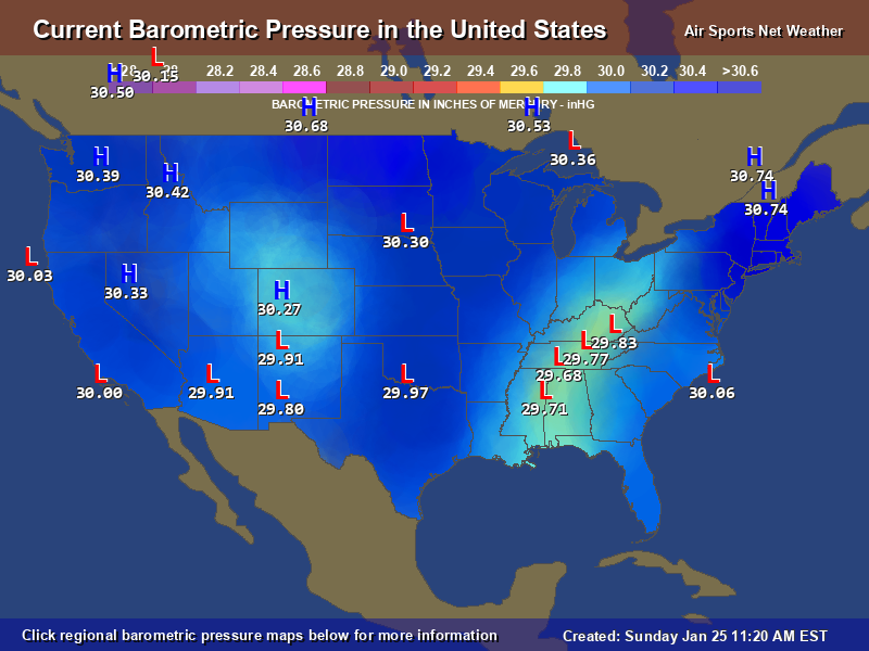
A hint of a transfer?? Some models have the mix line reach nyc ,then crash back south. We want that coastal to deepen,primary weakens.
-
Nice range in numbers,the bronx by now near 7. You guys at 3 on eastern l.i. west to east ..
-
For those to extrapolate. Yw.
-
I can confirm bud. Over 5 here,near 6 rn. Its still 9 degrees here.we jp here.
-
Because it has!. Snowing at 9/10 degrees rn is something most of us haven't experienced in nyc EVER!. I've blown past 5 approaching 6 inches already. 12 to 14 looking likely up here.
-
The city ranges are 3 to 5 already..the 8 inch mark is a guarantee now,especially with how hard its snowing rn.
-
Im telling you if this were to phase off the delmarva.. as of now there is a chance since a disturbance is already off the coast. Models show the primary coming up in to southern pa dunno about that... 9/9f.. Heavy snow currently. 4.8 down,might be 5 by the time I post this.
-
The lul lasted 6 minutes,now its heavy again. A foot is a 80% lock now across nyc.
-
Weak coastal off hatteras,nc currently, the tug of war has started. This is where models start to waffle. Almost every model has the weak coastal just off the nj coast later.
-
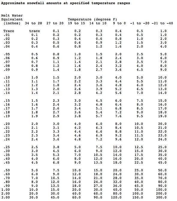
Its crazy because i put the chart up for ratios,a lot of folks weren't buying it. Rn im at 26 to 25 to 1@9 degrees. Close to 4@home.
-
Bingo. A lot of people disregarded the initial ratios. Im snowing at 9 degrees. 3 to 4 inches out here already and snowing hard. When the thumping precip gets here,ohhhh babyy!!.
-
In the brief time snowing,ive gotten 3+ inches already. Currently heavy snow,9/7f. This The type of snow you can see pile up per min.
-
Extreme Cold, Snow & Sleet: SECS 1/24 - 1/26
Bxstormwatcher360 replied to TriPol's topic in New York City Metro
Precip is racing in. Faster start time = more snow. Even if it changed over by 5 pm,that's 12 hours of heavy snow,if it started at 5am. Ill let everyone do their own math for shits and giggles. -
Extreme Cold, Snow & Sleet: SECS 1/24 - 1/26
Bxstormwatcher360 replied to TriPol's topic in New York City Metro
None taken..it is a general rule but not exactly what happens. But it is basic info for the newbies . Lol -
Extreme Cold, Snow & Sleet: SECS 1/24 - 1/26
Bxstormwatcher360 replied to TriPol's topic in New York City Metro
Which is why I mentioned,winds and upper air conditions. Surface temps are not exclusive to exact ratios anyway. If it feels like sand then there was some warmer air intrusion somewhere. -
Extreme Cold, Snow & Sleet: SECS 1/24 - 1/26
Bxstormwatcher360 replied to TriPol's topic in New York City Metro
Ratio chart. Onset liquid equivalent to snow is going to be bonkers. Other factors may slightly differ in ratios itself such as winds and upper air conditions.
-
10/-8f mostly cloudy now. It's def incoming.
-
Extreme Cold, Snow & Sleet: SECS 1/24 - 1/26
Bxstormwatcher360 replied to TriPol's topic in New York City Metro
Ill be here waiting on it.. trust me it might be epic around these parts if it never mixes. At the rates/ratios. It might be crazy for a while. -
Extreme Cold, Snow & Sleet: SECS 1/24 - 1/26
Bxstormwatcher360 replied to TriPol's topic in New York City Metro
Ive been rooting for the 557ww model. Last 3 days it has kept most of nyc snow along with the navgem models. -
Extreme Cold, Snow & Sleet: SECS 1/24 - 1/26
Bxstormwatcher360 replied to TriPol's topic in New York City Metro
My temp is running a degree cooler then progged rn,not much cloud cover so the temps are still dropping. 12/-9f currently. -
Extreme Cold, Snow & Sleet: SECS 1/24 - 1/26
Bxstormwatcher360 replied to TriPol's topic in New York City Metro
Boogie down here. -
Extreme Cold, Snow & Sleet: SECS 1/24 - 1/26
Bxstormwatcher360 replied to TriPol's topic in New York City Metro
Yep all areas mentioned are part of the nw bronx. Cooler areas with coastal elevation involved. We change last in every borderline storm. -
Extreme Cold, Snow & Sleet: SECS 1/24 - 1/26
Bxstormwatcher360 replied to TriPol's topic in New York City Metro
Im sticking to 10+ inches for the bronx. fieldston,riverdale,kingsbridge and norwood get a wee bit more. -
Extreme Cold, Snow & Sleet: SECS 1/24 - 1/26
Bxstormwatcher360 replied to TriPol's topic in New York City Metro
A 20 to 40 mile jog se is still possible. Things are trending better as the models finally pick up the cold suppression. All layers can warm up but against a solid cold dome,its gonna be tough going warming up any level ..925,700,850 for my location atleast doesn't reach 32f/0c. -
Extreme Cold, Snow & Sleet: SECS 1/24 - 1/26
Bxstormwatcher360 replied to TriPol's topic in New York City Metro
I remember that model from the early 2000's,it indeed had the highest score verification at that time. But it's good to know that its still going strong.


