

BaltimoreWxGuy
-
Posts
2,137 -
Joined
-
Last visited
Content Type
Profiles
Blogs
Forums
American Weather
Media Demo
Store
Gallery
Posts posted by BaltimoreWxGuy
-
-
2 minutes ago, Deer Whisperer said:
solid light snow already
2 minutes later mod snow
So not much Virga for you. Good sign I would think for us further north
-
Looks like DC should be in good returns in next half hour. Guess we’ll see how much dry air is an issue soon here
-
Pulling at straws but latest HRRR is encouraging in holding off the sleet line until noon-ish but it’s also pretty darn weak with precip up until about 10am-ish. Anyway, nap time. Guess we shall see how it looks come 5am
-
 1
1
-
-
Eh. The Euro isn’t overly exciting or a massive disappointment. 2”-3” for a lot of us at 18z Baltimore gets up to 4” in the hour or 2 after
-
HRRR is better for the Baltimore area particularly. I know some think it doesn’t matter but I’d rather see it get better than stand pat lol
-
3
-
-
Just now, Disc said:
Still all snow down here believe it or not.
Was that expected or no?
-
When you have widespread winter storm warnings, gonna have premature closures. Let’s face it, it doesn’t take as much snow these days to close things as it did 10-20 years ago
-
Just now, Steve25 said:
Is it my imagination or is the radar substantially ahead and healthier looking than lets say the HRRR?
Nope. It’s hard to believe that with a radar like that, this doesn’t come in hot and heavy around 6-8am. We’ll see if the global are right or the NAM/HRRR. Despite what some Mets say, I always like to blend GFS/Euro
-
1
-
-
1 minute ago, WesternFringe said:
I am just playing. I remember a storm last winter or the year before where that was your post repeatedly about a storm threat. Annoyingly, you were mostly right that time! lol
Honestly I do not think dry air is that big of an issue on this one. I think it is more about the trajectory of the heavy precipitation. That mostly goes well to our north west into the Ohio Valley And West PA. So basically I think the precipitation coming our way kind of Is getting sheared out and getting weaker as it comes Northeast. At least that’s how the models see it to a degree
-
2
-
-
Just now, WesternFringe said:
Do you know BaltimoreWxGuy by chance?
Hey I haven’t mentioned that word once yet
-
 3
3
-
-
ICON with delayed onset too but verbatim it looks like it rips from 10am-1pm. That’s our make or break time frame on if we get 1-2” or 2-4”/3-6”
-
Just now, WxUSAF said:
35/8
Car in garage, got firewood, and snowboard is in the yard.
And got 4 6-packs
1 beer for each .1 of an inch? Lol
-
1-2 extra hours of snow would probably mean 1-3” inches extra of snow in this scenario with pounding precipitation possible from 10am-1pm
-
1
-
-
1 minute ago, caviman2201 said:
The NWS Active Alerts map looks insane... never seen so many counties under some sort of winter weather advisory/warning...

You know flood watches in the south are generally good
-
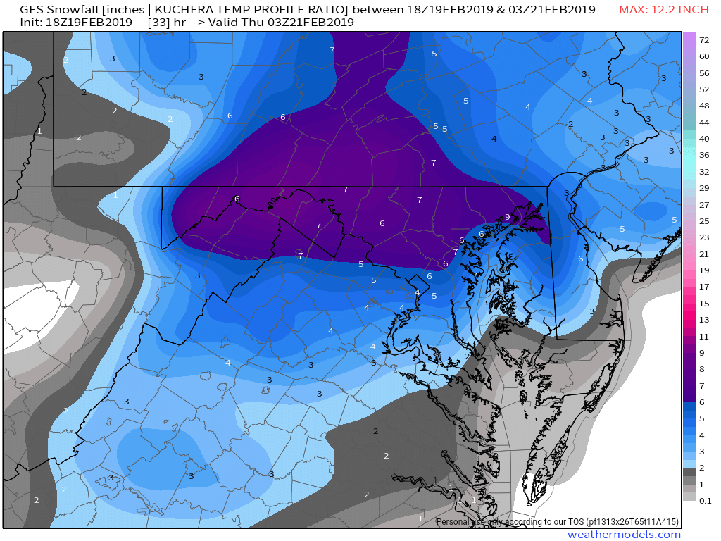
4 minutes ago, yoda said:
18z GFS Kuchera is 4" from EZF north

Figured the map would look something like that. Was deff better for DC-north
-
1
-
-
1 minute ago, Woodbridge02 said:
What "area"? Kuchera gives me like 2-3"
I guess it’s perspective. To me it looks better for DC-North which is probably a good 70% of this forum?
-
1
-
-
1 minute ago, Fozz said:
18z panel looks very juicy compared to the last run. Nice improvement.
I’m using the 3 hour panels on EWALL. It’s surely an improvement in terms of Precip and 850s anyway
-
GFS looks like a true 4-7” area wide to me
-
3
-
-
.71 bullseye in Montgomery county and it looks before the flip to me on GFS
-
GFS looks better. Especially for Baltimore. More precip and colder at 1pm
-
2
-
 2
2
-
-
3 minutes ago, mappy said:
no new posts in an hour? storm cancel? where am I?
How about some weenie radar hallucinations? The thunderstorm near Atlanta looks prime for tracking in our area

-
Look at the thunderstorm in Atlanta right now. Kinda looks like it’s aimed at us lol
-
2 minutes ago, SnowGolfBro said:
It may not mean much for us in the DC area, but the radar is blossoming and very impressive In the South at the moment. Looks very dymamic.
I think part of the problem is, that real heavy stuff just isn’t going to be aimed at us...it’s gonna go into the Ohio valley and west PA. If it was aimed at us it’d be a big time snow storm, that stuff may rob some of the heavy moisture to the east.
-
LWX updated their snow maps. Doesn’t look to be much of a change. If I get 5” I’ll be very happy

2/19-20 Winter Storm Observations
in Mid Atlantic
Posted
I know models don’t matter much but I still like the GFS and the newest HRRR delays sleet until 2pm. Around 4” up here in Baltimore, I’d take it and run