

BaltimoreWxGuy
-
Posts
2,137 -
Joined
-
Last visited
Content Type
Profiles
Blogs
Forums
American Weather
Media Demo
Store
Gallery
Posts posted by BaltimoreWxGuy
-
-
Just now, Buildthewall said:
All the people saying it wont accumulate......
Wow. Extremely impressive. I think when most people say it won’t accumulate much they are talking about roads, pavement etc.
-
 1
1
-
 2
2
-
-
5 minutes ago, jayyy said:
Heavy snow. Sticking to cars trees and sidewalks beginning to cave. LMAO at the “it won’t stick bc it was too warm” crowd.
Climo...I live Dundalk by the bay, and it’s not sticking. Zone forecast is now less than 1”
-
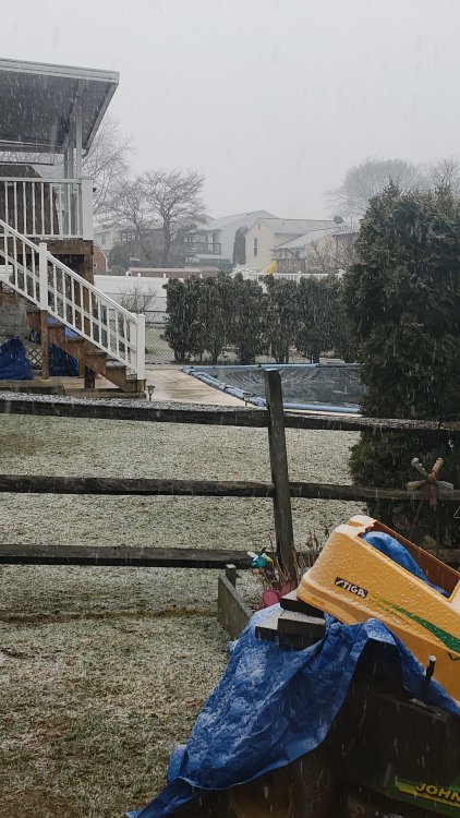
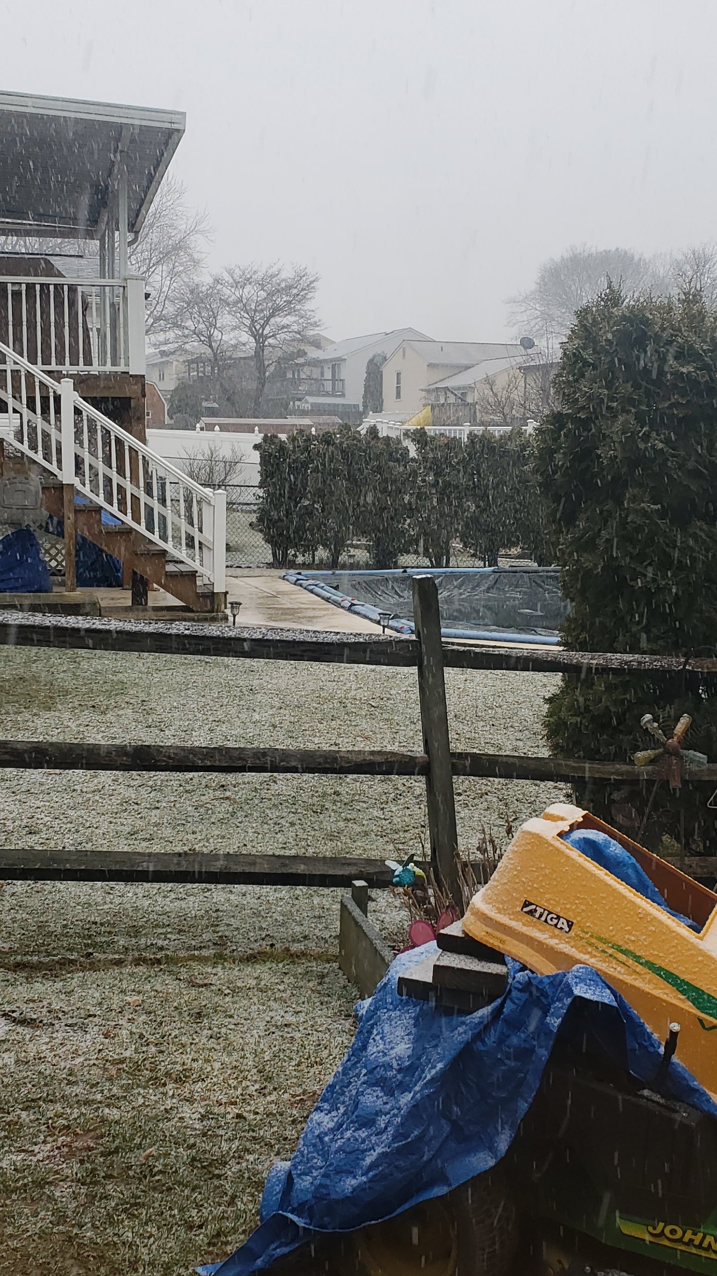
Light white rain in Dundalk. Flakes really have that wet look and it’s coming straight down. Bet I switch to rain pretty early despite the relatively cold 850s. Near the bay just isn’t gonna work
-
For what it’s worth the Euro did cut back on snow particularly around I95 in DC and Balt. Not surprising. But stil 6-7 totals in northern MD
-
I’m at 39. Even a 6 degree temperature drop from Evap cooling in my opinion is asking for a lot down this way.
-
2 minutes ago, T. August said:
Hrrr is awful. 4-5 for psu and jack shit below ~600ft.
It could be right. Don’t trash it yet
-
8 minutes ago, JakkelWx said:
Mike Masco has me under 3-6''

He seems to have become a real weenie since he went to Philly
-
2 minutes ago, jayyy said:

You’re gonna end up disappointed in Ellicott City
-
4 minutes ago, psuhoffman said:
I can only handle so much stop
A friend at work lives east of the city in middle river. He moved there from Harford county years ago and is always complaining how he gets less snow then everyone else even in the city. I keep telling him if he commuted from the same distance to the northwest he would probably get about 10” more a year and 1-2” more (at least) in most storms.
I would agree with that lol. Low elevation and the bay are a b*tch
-
It’s 40 in the Dalk. Hard for me to buy much more than 1” of stop. Just not enough cold air around
-
Interesting that there’s a winter storm watch in Chestertown on the eastern shore...it’s literally due east across the bay from Dundalk/ESsex. I think their criteria is a little lower with 2-4 but still
-
 1
1
-
-
2 minutes ago, MD Snow said:
the 6hr maps on tt never change Baltimore to rain on the 18z gfs.
Didn’t think they really didn’t on 12z either
-
6 minutes ago, ers-wxman1 said:
This is clearly an event from I-81 to northern Loudoun and areas near and north of I-70 to the M/D line. 5-9 inch solid event is my call there. MRB to Reisterstown jackpot zone.
I would be surprised to see 3-4” even out here in the Ashburn/Leesburg area. D.C. proper will be lucky to see 1”. South and east of there a dusting then rain.
Dundalk Md? Ya know since we’re being location specific and all

-
1
-
-
5 minutes ago, Interstate said:
Up until last night the Euro snow map was blank
Well you know what I’m saying. I think it’s better at calculating on the snow amounts on the edges of the rain/snow line etc
-
4 minutes ago, jayyy said:
Stop hugging rain snow lines. Surface is almost always colder, precip is almost always more jacked than progged
Too close to the storm to be using the Euro frankly. NAM/GEM/RGEM/GFS blend at the 24 hour mark will do. GEM says 10” in Baltimore. Euro says 2” lol. No wonder LWX has zero clue how to handle the Baltimore area. Going to be a VERY close call for me here in far western Ellicott City along 108
I think the Euro has a lot more realistic algorithm in calculating on the snow maps than the other models especially the GEM. But yeah it’s still really close but you would think this is classic elevation dependent for the higher totals
-
14 minutes ago, Mdecoy said:
I think this is a none event for I-95 corr.
But you will basically be able to walk to snow.
I don’t think it’s a non event, well I guess it depends on the definition but I95 around Baltimore I think has a chance for a couple of wet inches mainly on cold surfaces hence the advisory.
-
17 minutes ago, Maestrobjwa said:
Hey @North Balti Zen @nw baltimore wx @BaltimoreWxGuy Let's all meet in the northwest corner of the city, lololol How Baltimore gets the tiniest corner here is hilarious!
As long as it’s not around North Avenue I’m in lol
-
2
-
-
Just now, MD Snow said:
snow maps, blah. 6z looked better even easter of the cities.
Easter? Lol that’s a few weeks away
-
1 minute ago, Scraff said:
12K NAMing?

The snow map doesn’t make sense with what the conditionals show for our area. So one of them is wrong. Shows how tight this storm is though. Got to think elevation plays a role
-
1
-
-
Metro Baltimore stays right on the rain snow line thru the duration on the 3K. Lol that’ll make for a difficult forecast
-
The onset on the 3K is a couple hrs later than 12k which in my opinion is good. I’d rather get the snow burst after 3 and have a chance of it still snowing near sunset than at noon or 1 and already mixing with or changing to rain by 4
-
1
-
-
3K has a nice snow burst from 3-5pm for most of us
-
5 minutes ago, MD Snow said:
12k is a nice front end thump before changing to rain for the cities. PSU’s dream for his back yard.
Yeah but it’s hard for me to believe that snow is going to accumulate well in the mid afternoon around the metros. We need to switch back to snow in the mid to late evening and pick up a couple of inches at the end
-
23 minutes ago, MD Snow said:
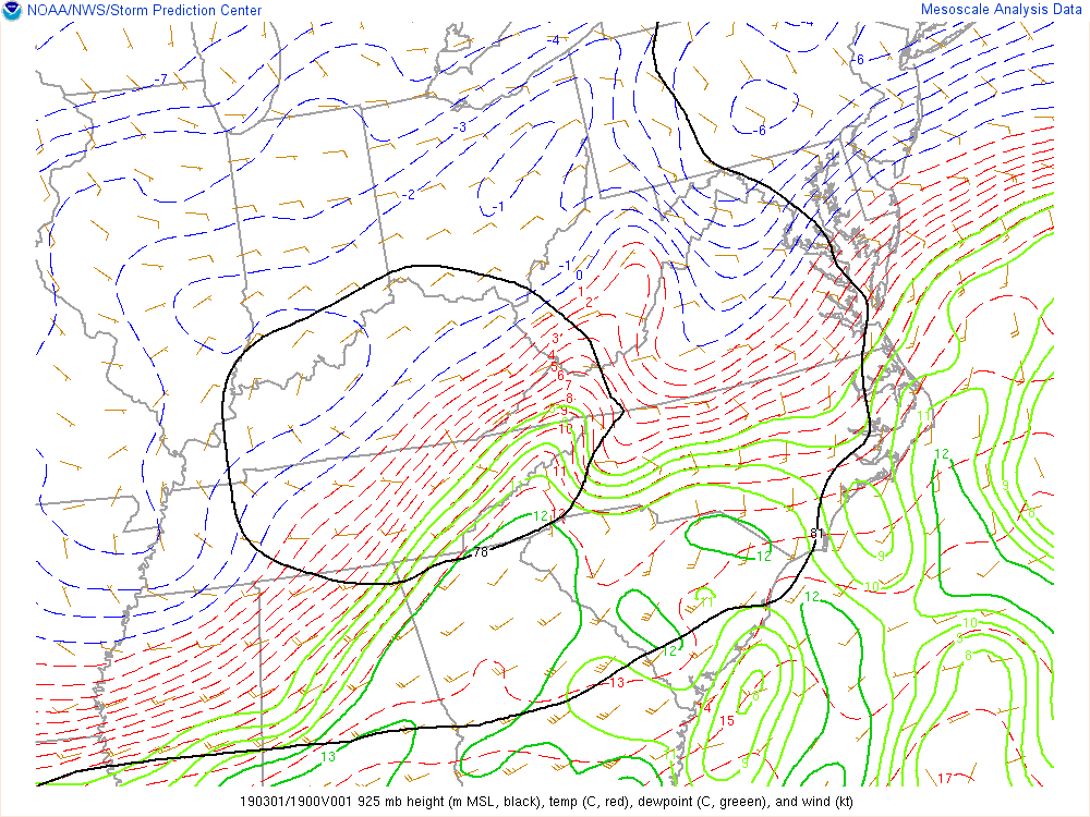
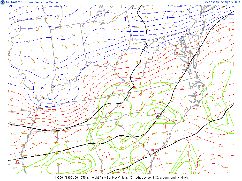
Yeah, maybe one of the red taggers could chime in here but given the current 925 mb and 850 mb temps and surface temps around 33-34, I'd think areas north west of dc and 95 have a good chance at mixing tonight especially if precip is heavy. Take a degree away from the sun going down and then another with the heavy precip mixing some cold down and it could get interesting.
Can you keep posting these or send a link on where to see them?

March 3-4, 2019 Snow Discussion and Obs
in Mid Atlantic
Posted
Hmm, NWS is reporting 37 at the Naval Academy as of a few minutes ago