.jpg.93eb8afe5d1df4d67bc0eeb78d645380.jpg)
.jpg.7cbeb4b469bd18d447fac5868c43a091.jpg)
Yardstickgozinya
-
Posts
1,251 -
Joined
Content Type
Profiles
Blogs
Forums
American Weather
Media Demo
Store
Gallery
Everything posted by Yardstickgozinya
-
.thumb.jpg.6a4895b2a43f87359e4e7d04a6fa0d14.jpg)
Central PA Winter 25/26 Discussion and Obs
Yardstickgozinya replied to MAG5035's topic in Upstate New York/Pennsylvania
The sun wasn't even close to coming up when I had posted this but it was all, but maybe thirty minutes after I posted that everything completely dissipated. NWS did mention in their forecast discussion that very little snow was reaching the ground from that first wave. -
Central PA Winter 25/26 Discussion and Obs
Yardstickgozinya replied to MAG5035's topic in Upstate New York/Pennsylvania
This baby looks pretty sweet.

-
Central PA Winter 25/26 Discussion and Obs
Yardstickgozinya replied to MAG5035's topic in Upstate New York/Pennsylvania
The good news is NWS has Increased their confidence in a winter storm during Sun-Mon timeframe. The bad news is NWS has lowered confidence in the occurrence of precipitation Sun-Mon. Once again they're getting all the angles covered. Area Forecast Discussion National Weather Service State College PA 444 AM EST Tue Feb 10 2026 .WHAT HAS CHANGED... * Increased confidence in winter storm during Sun-Mon timeframe * Holding off on any winter weather advisories for possible ice accums for E/NE this evening-SW later tonight && .KEY MESSAGES... 1) Light precip possible later today and this evening, with light post-frontal snow showers and gusty winds over the Alleghenies later tonight through Wednesday night. 2) Lowered confidence in occurrence of precipitation Sun-Mon. Confidence in timing of possible precip is slightly higher. Confidence in precip types/amounts remain low -
Central PA Winter 25/26 Discussion and Obs
Yardstickgozinya replied to MAG5035's topic in Upstate New York/Pennsylvania
Well, I'll be d***** . Looks like that might be able to sneak in here.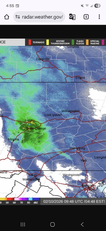
-
Central PA Winter 25/26 Discussion and Obs
Yardstickgozinya replied to MAG5035's topic in Upstate New York/Pennsylvania
I think the end of the month and early next month look interesting, but until I actually see snow falling.this coming weekend I'm comfortable right here in the doo doo camp. The difference between me and some others not feeling the upcoming pattern, is that I want my intuition to be completely wrong. The way I see it, is if i'm wrong, everybody here that actually enjoys winter wins including myself. I'd rather be buried in snow than be right. I think this winter is far from dead just to be clear, which is a long ways from my DOA thoughts in November. -
Central PA Winter 25/26 Discussion and Obs
Yardstickgozinya replied to MAG5035's topic in Upstate New York/Pennsylvania
It was quite beautiful around here yesterday. I ended up with a dusting .The wind arrived here in Fareview township around 1:45AM and snow showers have returned just after 2:00AM. -
Central PA Winter 25/26 Discussion and Obs
Yardstickgozinya replied to MAG5035's topic in Upstate New York/Pennsylvania
Unfortunately there's no do all end all for ice and compacted snow, if you don't want to completely kill yourself or have it sliding off a spade shaped shovel you need to break it up with something narrow and scoop it up with something wide if you wanna make it easy on yourself. -
Central PA Winter 25/26 Discussion and Obs
Yardstickgozinya replied to MAG5035's topic in Upstate New York/Pennsylvania
I also forgot to mention that some of the roofing spades and shingle removers come in real handy for snow and ice removal. -
Central PA Winter 25/26 Discussion and Obs
Yardstickgozinya replied to MAG5035's topic in Upstate New York/Pennsylvania
This here is my forged steel ice scraper/chopper that I got at J&W Hardware in Etters. I've also recommended you guys try a six, tine, forged pitchfork like, in my picture. Obviously I use my chopper for chopping and scraping, but sometimes the pitchfork is the way to go for scraping if the ice is loose, or you have time to wait for magnesium or chloride to loosen it up.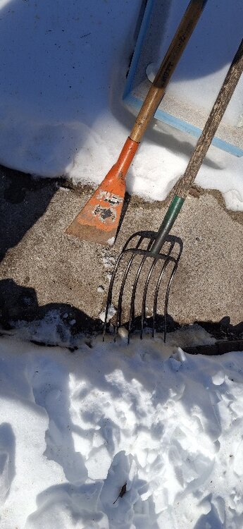
-
Central PA Winter 25/26 Discussion and Obs
Yardstickgozinya replied to MAG5035's topic in Upstate New York/Pennsylvania
My expectations for this winter weren't that high to begin with .The pattern has already verified quite a bit colder then I would have thought, due to my solar cycle biases. Hopefully, when we reap the benefits of the SSW later this month we're not in the hostile phases of the MJO and can time some other interactions properly. As far as any guidance goes, I don't put any emotion or thought into any qualitative or quantitative forecast this far out for a number of my own reasons, but mainly because I just can't handle the f****** ride. Until we're inside 96 to 72 I view most of the data as noise and look for other cues .
-
Central PA Winter 25/26 Discussion and Obs
Yardstickgozinya replied to MAG5035's topic in Upstate New York/Pennsylvania
That would be classic. There's a special place for guys like us.I'll be waiting at the gates for you. -
Central PA Winter 25/26 Discussion and Obs
Yardstickgozinya replied to MAG5035's topic in Upstate New York/Pennsylvania
Mood flakes are flying here. Nice size flakes. Good call, SnowNuts. -
Central PA Winter 25/26 Discussion and Obs
Yardstickgozinya replied to MAG5035's topic in Upstate New York/Pennsylvania
Oh snap !! When you and blizz team up, for a good one, I expect at least 3 solid inches. -
Central PA Winter 25/26 Discussion and Obs
Yardstickgozinya replied to MAG5035's topic in Upstate New York/Pennsylvania
I don't think kicking it in the high gear Is the right way of putting it lol. As you already know a subconscious turning off of the key is more like it. Unfortunately it doesn't matter if it's fake blood on TV or CGI of someone hanging on a cliff that s*** can be completely lights out for me. I had a really bad episode with it my last hospital visit and the doctor's we're about to use the defibrillator on me. I might have to consider a pacemaker for my condition if it gets much worse even though my heart looks to be completely healthy. -
Central PA Winter 25/26 Discussion and Obs
Yardstickgozinya replied to MAG5035's topic in Upstate New York/Pennsylvania
@Jns2183 I forgot to mention that it's also getting worse for me as I get older and obviously during high stress. -
Central PA Winter 25/26 Discussion and Obs
Yardstickgozinya replied to MAG5035's topic in Upstate New York/Pennsylvania
Yikes. I'm sorry to hear that you had to go through that. I'll have to ask my mother, but I never had that test done that I know of or i'm just too young to remember. That said ,If the experience was true too traumatic, I would have passed out anyways. I've had it as long as I can remember and it's triggered by a lot of different types of stimuli, but heights ,blood, looking at sharp objects, brain freezes, and sudden boom's are big ones I have to be extra mindful of if i'm in a working environment. I would fully imagine its probably one of the main reasons I'm always looking for lightning. I love it, but I don't want it to sneak up on me when i'm running equipment. -
Central PA Winter 25/26 Discussion and Obs
Yardstickgozinya replied to MAG5035's topic in Upstate New York/Pennsylvania
Yep, definitely the good old days. I actually fell through ice as a kid while my buddies and I were beating the s*** out of each other with catty nine tails. It was a containment ditch that we caught frogs in so we knew that it was only waste deep in the middle., but never considered how cold the walk to the nearest home would be if we did fall through. -
Central PA Winter 25/26 Discussion and Obs
Yardstickgozinya replied to MAG5035's topic in Upstate New York/Pennsylvania
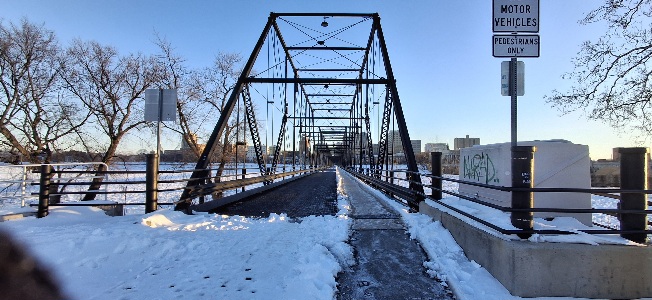
I could have got some killer shots from the bridges this morning, but old Yardstick is absolutely terrified of bridges and heights beyond a neurotypical's understanding.. I tried my best but fear and the resulting low blood pressure wouldn't let me walk out on the bridges more than a couple feet before my Visovasal sinscope would attempt to knock me out cold. -
Central PA Winter 25/26 Discussion and Obs
Yardstickgozinya replied to MAG5035's topic in Upstate New York/Pennsylvania
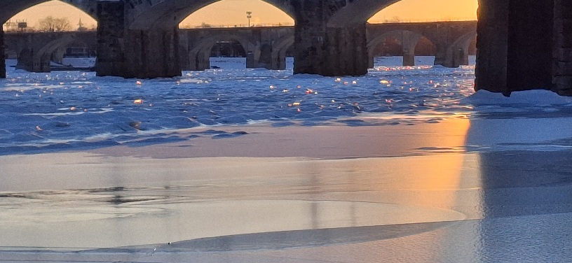
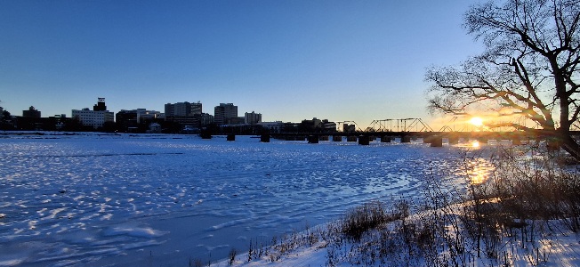
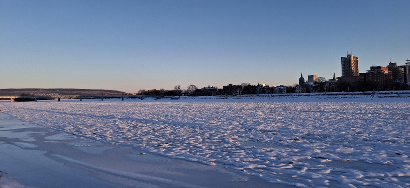
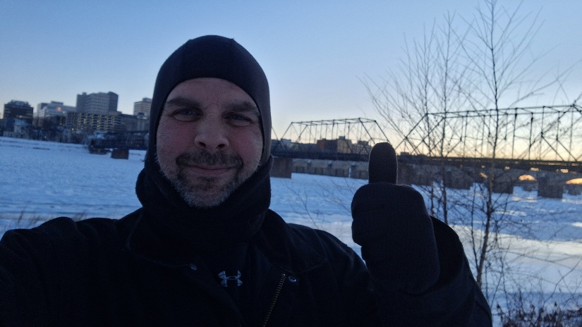
I originally planned my trip to city island to take photos this morning, because I was hoping to catch the full moon and snowy landscape in some of my photos. Unfortunately, when I got there today, there was no good angles to capture the moon and the landscape from City Island, so unfortunately that didn't work out. I have better photos that I will be putting up but I ended up taking over 400 photographs this morning and have a lot of looking through to do to find the best photos. Everything I posted so far was from my cellphone and not my dslr. I also have no clue how to do photography so I took all the photos in several different landscape modes because I didn't know what would offer the best quality photos in the conditions.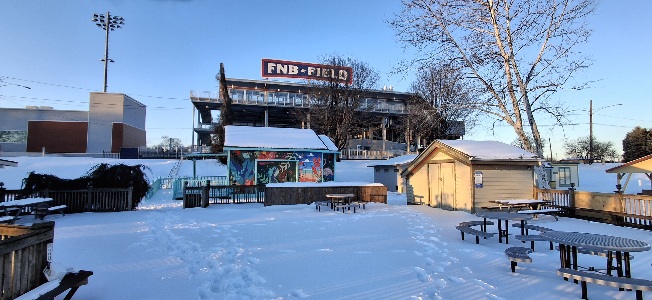
-
Central PA Winter 25/26 Discussion and Obs
Yardstickgozinya replied to MAG5035's topic in Upstate New York/Pennsylvania
I didn't know it was safe. Thanks for letting me know. I'm almost half way across the river now just above Dock Street dam. -
Central PA Winter 25/26 Discussion and Obs
Yardstickgozinya replied to MAG5035's topic in Upstate New York/Pennsylvania
-
Central PA Winter 25/26 Discussion and Obs
Yardstickgozinya replied to MAG5035's topic in Upstate New York/Pennsylvania
-
Central PA Winter 25/26 Discussion and Obs
Yardstickgozinya replied to MAG5035's topic in Upstate New York/Pennsylvania
I'm down here at City Island at the crack of dawn shooting some pictures with my dslr, although I forgot my d*** tripod.I'll post when I get home.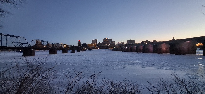
-
Central PA Winter 25/26 Discussion and Obs
Yardstickgozinya replied to MAG5035's topic in Upstate New York/Pennsylvania
These are the first big changes we've seen to the SPC outlook in a long time. SPC will transition to issuing conditional intensity information beginning with the 1630Z (10:30 AM CT) Day 1 Changes to Storm Prediction Center (SPC) Day 1, 2, and 3 Convective Outlook Probabilities of Significant Severe Hazards on March 3, 2026 https://www.spc.noaa.gov/exper/conditional-intensity-information/ -
Central PA Winter 25/26 Discussion and Obs
Yardstickgozinya replied to MAG5035's topic in Upstate New York/Pennsylvania
Maybe he's being held captive by a map hating insane forum member, and that's actually an imposter that we're talking to.