

AtlanticWx
-
Posts
650 -
Joined
-
Last visited
Content Type
Profiles
Blogs
Forums
American Weather
Media Demo
Store
Gallery
Everything posted by AtlanticWx
-
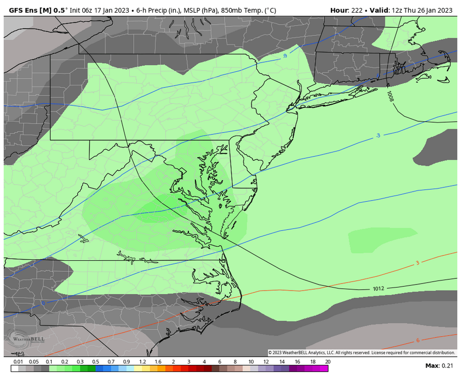
6z gefs, the 26th/27th is our best chance the next few days
-
we can hope! imo we could end up w/ a 2008-09 type winter where we get one snow event late jan, an SSWE and a good storm in march
-
what's pd3?
-
growing support for an SSWE per the weeklies
-
who's gonna win, strong TPV lobe(s) or a weak SE ridge? obviously the se ridge!
-
i do have a good feeling ab this pattern just gotta hope things continue to trend better
-
Warm? Temp anoms are consistently below 0C throughout the entire run past the 26th and best of all -
-
i mean if we really wanted to analyze that look verbatim it'd be a miller B transferring off the coast bc of that monster 50/50 low
-
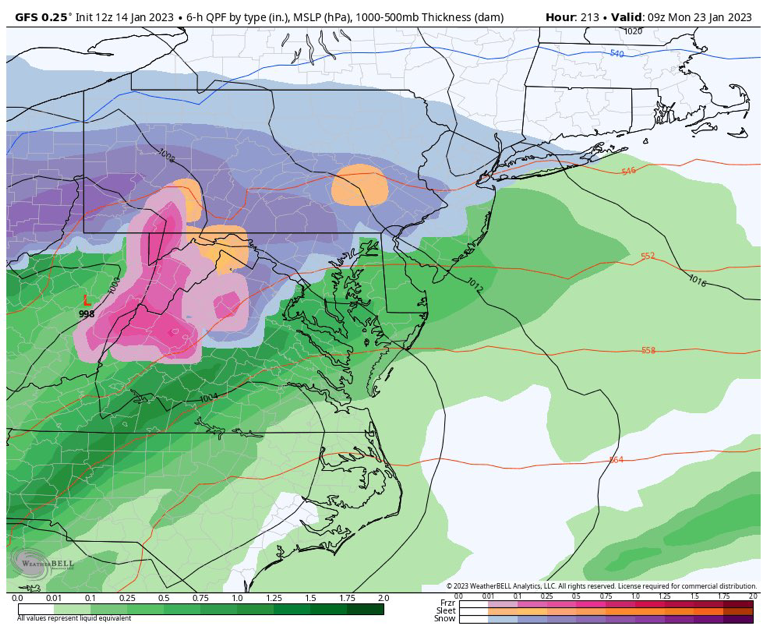
don't look at the 18z gfs for 384 hours out
-
2 inches for an ensemble mean where all of it falls between the 23rd and 30th is a good run. 50-60% chance of >1" that far out is pretty good but ok
-
the 27th setup is actually quite simple, j a wave sliding along a boundary. the complex part ab it is where the boundary would setup as a change in the two or three storms before it and whether or not they trend weaker or stronger could mean less/more cold air ergo setting up the boundary somewhere else
-
yeah as CAPE said that timeframe from 27th onwards looks interesting. and heights have def been lowering past few runs on GEFS towards the end of jan continued trends should squash the se ridge enough for a nice overrunning pattern around here & we're still 10 days out so a lot can change either for the good or bad
-
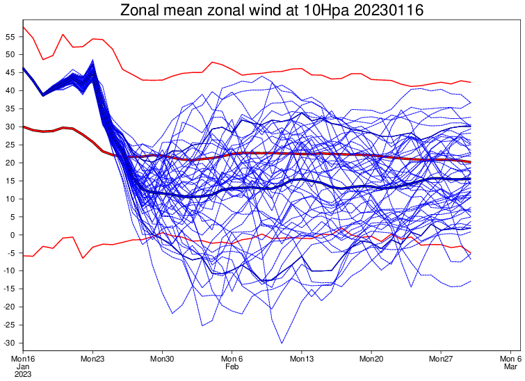
the key takeaway i've been seeing from ensembles is that TPV lobe trending stronger; the stronger it trends the closer we get to a CMCE type look
-
it's something
-
if the troughing near 50 N/50 W trends stronger which it looks like it has been, that should be enough for CAD events here.
-
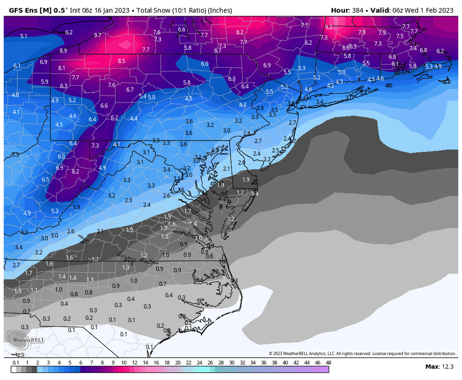
this forum needs some glimmer of hope so while weeklies are quite inaccurate 30 days out you can see the effect of the SSWE as shown on the weeklies towards the latter half of feb se ridge seems to become more muted and cold seems to slowly press down. again, don't take that as a forecast just stating what i see verbatim
-
GEFS also has a ~2" mean for much of the area with just the 27th threat, which is pretty big this far out
-
step up from past runs we had snow here lmao
-
surprised no one looked at the 12z gfs, looks a lot more wintry compared to previous runs
-
exactly this, we live in dc you genuinely cannot expect every event to be some crazy all snow event
-
on the bright side some seasonals have average temps in feb which is saying something?
-
marchs been pretty reliable recently tbh, i wouldn't count it out. a solid 3-5" snowstorm like last year would make a lot of ppl happy
-
snow in march is still snow, idk why everyone's so picky ab snow
-
we don't do complicated around here
-
The LR pattern around the 27th looks pretty favorable for something around here if a wave rides up that boundary along the SE ridge.


