

RU848789
-
Posts
4,002 -
Joined
-
Last visited
Content Type
Profiles
Blogs
Forums
American Weather
Media Demo
Store
Gallery
Everything posted by RU848789
-
Extreme Cold, Snow & Sleet: SECS 1/24 - 1/26
RU848789 replied to TriPol's topic in New York City Metro
That's incorrect. Mt.Holly is only 5" south of 276/195; 6" north or there and contiguous with Upton... -
Extreme Cold, Snow & Sleet: SECS 1/24 - 1/26
RU848789 replied to TriPol's topic in New York City Metro
Thanks, fixed the post... -
Extreme Cold, Snow & Sleet: SECS 1/24 - 1/26
RU848789 replied to TriPol's topic in New York City Metro
But I'd take the over at Bryant Park nearby if someone else is measuring, lol. -
Extreme Cold, Snow & Sleet: SECS 1/24 - 1/26
RU848789 replied to TriPol's topic in New York City Metro
Edit: updated as I had the 2:24 am map up (thought it was pm D'oh!), although the new map still has most of CNJ in an 8-12" swath, so changing the warning to 6-10" for Morris-Hunterdon-Somerset-Middlesex-Mercer-Salem-Gloucester- Camden-Northwestern Burlington-Cumberland-Delaware-Philadelphia- Western Chester-Eastern Chester-Western Montgomery-Eastern Montgomery-Upper Bucks-Lower Bucks seems unnecessary. Just keep it at Morris-Hunterdon-Somerset-Middlesex-Mercer and SEPA and at 8-12" and put the SNJ counties at 5-8" with Monmouth/Ocean. 'm missing something, as almost every model shows 6-8" of 10:1 snow for CNJ (8-11" with 13-14:1 ratios) and some show 8-11" of 10:1 snow and the NBM is still showing 9-10" (at model ratio); only the NAM shows 4-6" of 10:1. And then add another 1"+ of sleet and sticking with their 7-13" range (or 8-12" which I like better)would've been fine, IMO. Also, as I've said since their first map came out, they should've started with 8-12" and adjusted upwards if needed; starting at 12-18" for everyone was a recipe for walking it back for 2+ days. I don't get it - and I think 6-10" for CNJ, for example, might be on the low side a little. -
Extreme Cold, Snow & Sleet: SECS 1/24 - 1/26
RU848789 replied to TriPol's topic in New York City Metro
Great point. Here's the NAM GIF for the last 36 hours with essentially nada in LR. -
Extreme Cold, Snow & Sleet: SECS 1/24 - 1/26
RU848789 replied to TriPol's topic in New York City Metro
If meteorologists weren't so fixated on snow depth, but instead focused on frozen mass, 2" of sleet, alone, which is equivalent in frozen mass to 6" of 10:1 snow, would qualify for a warning. Same impacts on transportation and shoveling/plowing, plus it melts more slowly due to the much lower surface area to volume ratio. It doesn't have visibility issues, though, and it's not as pretty, but it's just about as impactful on the public. -
Extreme Cold, Snow & Sleet: SECS 1/24 - 1/26
RU848789 replied to TriPol's topic in New York City Metro
Damn, now we have to worry about the sun angle...at 15F, lol. -
Extreme Cold, Snow & Sleet: SECS 1/24 - 1/26
RU848789 replied to TriPol's topic in New York City Metro
Just caught up and surprisingly, didn't see the NWS snow/ice maps, so here they are. I had also summarized all of the NWS-Philly/NYC warnings elsewhere, so sharing them here. Nice to see the NWS finally bringing snowfall forecasts in line with the models and most other forecasters - I think a general 8-12" of snow and sleet for most S of 78 and more N of there and NE through NYC and the LHV/CT is pretty good. The NWS has me at 11.9" of snow/sleet, which I think is still a little high, so I'll go with 10.4" for Metuchen. NWS-Philly Counties For Sussex-Warren-Carbon-Monroe-Lehigh-Northampton, the warning is for 11-15" of snow/sleet, but no freezing rain (ZR) For counties in PA/NJ south of 78 (except coastal counties south of Ocean), i.e.,Hunterdon-Somerset-Middlesex-Monmouth-Mercer-Salem-Gloucester-Camden-Burlington-Ocean-Cumberland-Berks-Delaware-Philadelphia-Chester-Montgomery (and Newcastle/Kent in DE), the warnings are for 7-13" of snow and sleet with up to 0.3" of freezing rain accretion, especially SW of Trenton as per the ice map below. For Atlantic/Cape May counties and southern DE, the warning is for 4-8" of snow/sleet plus about 0.1" ZR NWS-NYC Counties For W. Passaic, the entire Hudson Valley and the coastal CT counties, the warning is for 12-16" of snow For NENJ (Union/Essex/Hudson/Bergen/E Passaic), NYC and LI, the warning is for 10-14" snow/sleet plus a light glaze of ZR -
Extreme Cold, Snow & Sleet: SECS 1/24 - 1/26
RU848789 replied to TriPol's topic in New York City Metro
The NWS finally dropped their snowfall forecasts (new and previous attached) to a somewhat more reasonable level, especially S of 78 where sleet will likely be at least at a moderate level. Likely tied to the NBM drop. -
Extreme Cold, Snow & Sleet: SECS 1/24 - 1/26
RU848789 replied to TriPol's topic in New York City Metro
I think everyone knows we have warnings up for everyone covered by the NWS-Philly and NYC offices. A summary is bulleted below, as I find wading through the full text to be tedious; the first 4 bullets are the counties under the NWS-Philly, while the last 2 are under NWS-NYC. One can argue that these numbers are a bit aggressive vs. other forecasters, but the NWS hasn't wavered, really, other than knocking down snowfall forecasts a bit south of 78 due to some sleet and adding in some ZR. There are also some models that show 10"+ amounts given good ratios (like 12-15:1), so it's not like the forecast is crazy, just higher than most; their latest map s arebelow. With temps below 20F for most and some wind, it'll be frigid and salt won't work as well, plus there will be some wind (20-25 mph) so some drifting is possible. For counties S of 276/195 in SEPA/SNJ/N DE, the warning is for 8-12" of snow/sleet plus about 0.3" of freezing rain (ZR) For Atlantic/Cape May counties and southern DE, the warning is for 6-10" of snow/sleet plus about 0.1" ZR For Sussex/Warren/Poconos/Lehigh Valley, the warning is for 12-18" of snow plus a light glaze of ZR For Morris-Hunterdon-Somerset-Middlesex-Monmouth-Mercer-Ocean-W Montco and Bucks, the warning is for 10-15" of snow/sleet, plus about 0.1" of ZR For W. Passaic, the entire Hudson Valley and the coastal CT counties, the warning is for 12-16" of snow For NENJ (Union/Essex/Hudson/Bergen/E Passaic), NYC and LI, the warning is for 10-14" snow/sleet plus a light glaze of ZR https://forecast.weather.gov/wwamap/wwatxtget.php?cwa=PHI&wwa=winter storm warning -
Extreme Cold, Snow & Sleet: SECS 1/24 - 1/26
RU848789 replied to TriPol's topic in New York City Metro
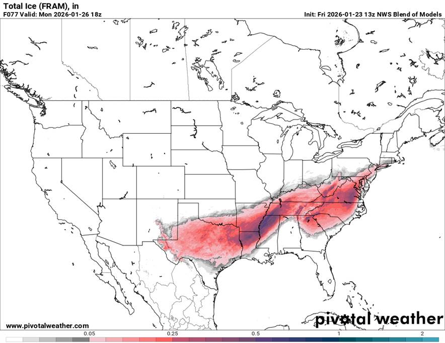
This is going to be one of the most impactful winter storms this country has ever seen. Here are the snow and freezing rain (ZR) maps for the US from the NBM (model blend). A foot+ of snow from Texas to Maine is insane and crippling 1"+ ice storms south of that snow for many may be even more impactful. Also, if you look at these same maps from 3 days ago, below, you can see how much further south the big swaths of snow and ice were (when most of us were worrying about suppression) – they’ve moved northward about 150 miles, as the modeling and the actual system have evolved, but that’s not an unusual track forecast error that far out. But I’m sure it’s disappointing for the folks who are snow lovers who thought they were getting a foot of snow and who will now likely be getting up to 1” of ice.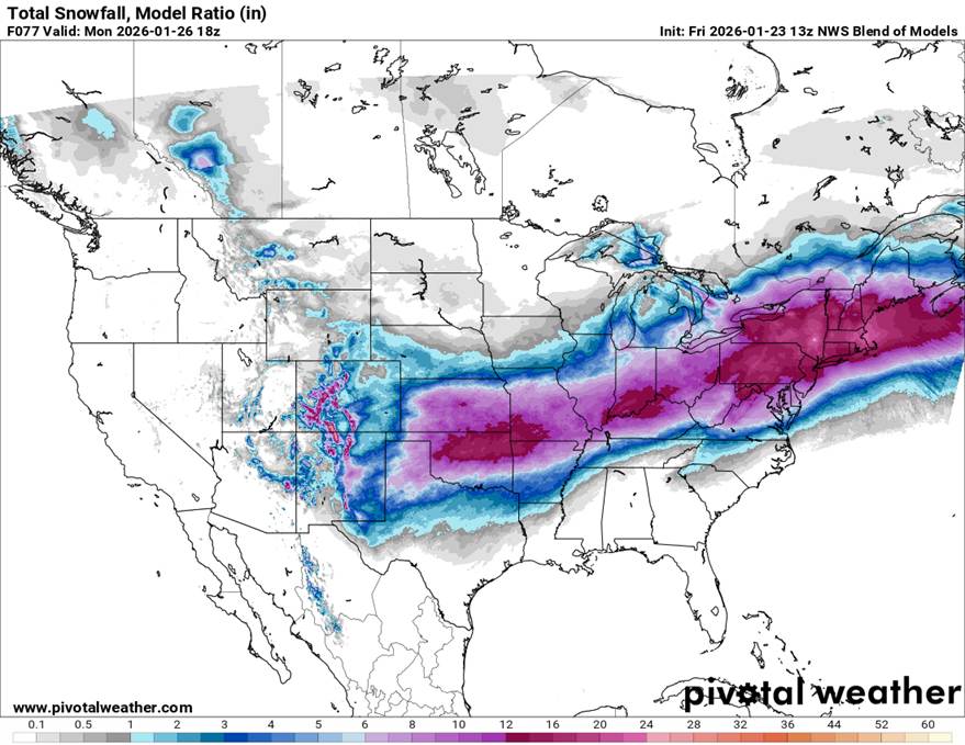
-
Extreme Cold, Snow & Sleet: SECS 1/24 - 1/26
RU848789 replied to TriPol's topic in New York City Metro
Sleet also melts more slowly than snow, given its much lower surface area per volume ratio. -
Extreme Cold, Snow & Sleet: SECS 1/24 - 1/26
RU848789 replied to TriPol's topic in New York City Metro
Was out at poker night but am now caught up and would love for the GFS or AIFS/AIGFS to be right and give most of CNJ and the 95 corridor from Philly to NYC and the coast and my house very little sleet/ZR, but we've seen too many times when the WAA is undermodeled and with several other models showing 25-40% of the QPF falling as sleet, mostly, with a bit of ZR it seems quite possible we'll at least get 33% as sleet/ZR. Here's some thoughts for how to look at that. I still think mets need to find a way to report total frozen mass in mixed precip events as frozen mass is much better correlated to impacts than simple depth. I have to say this at least once a day, lol. Seeing QPFs of 0.9-1.5" across the models, if I take 1.2" as the QPF and have 66% of it be snow, that's 0.8" as snow and 0.4" as sleet/ZR, so let's say that's 0.3" as sleet and 0.1" as ZR. At 13:1 SLR (the rough ratio seen on the NBM through 0Z Monday when many models switch to sleet), the 0.8" QPF as snow is 10.4" of 13:1 snow, the 0.3" of QPF as sleet is 0.9" of sleet for a depth of 11.3" and the 0.1" of QPF as ZR has no depth as it's just absorbed into the snow/sleet pack although some compaction and freezing will occur, especially near the top Bottom line this could end up having 10" of depth after compaction containing 1.2" of QPF which has a top several inches being frozen solid with surface temps in the mid/upper 20s. This is a friggin' mess to drive in, walk on, plow, shovel, etc., and likely worse than dealing with that same 1.2" QPF of frozen mass as pure 15:1 snow or 18" of depth. Won't be nearly as pretty, but will be as or more impactful. And if there's more like 50% of the 1.2" QPF as snow (7.8" at 13:1) and 50% of the QPF as sleet and no ZR (2" of sleet at 3:1), that's 9.8" of depth and keep in mind that sleet melts much more slowly than snow as it has a far lower exposed surface area per unit volume. -
Extreme Cold, Snow & Sleet: SECS 1/24 - 1/26
RU848789 replied to TriPol's topic in New York City Metro
DT/WxRisk's first guess map is the best one I've seen and I'd say I'm very aligned with it, as it has most of CNJ and 95 from Philly to NYC in the 8-12" of snow swath and noting that much of that area would also be receiving sleet; he doesn't specify how much sleet, but it's part of the 8-12" of "snow". I also like his 12-18" area with no sleet beginning around 78, which is a good guess. I might have his light blue area with a changeover to sleet/ZR all the way up to 78, though. I know he's a polarizing figure, but I like his work sometimes. The new NWS maps and discussion aren't up yet, but they did update their winter storm watches, below, which essentially have 12-17" of snow (and some sleet and up to 0.1" of ZR) for the counties N of 276/195 in PA/NJ (and Ocean), while they have 8-15" of snow and sleet with up to 0.25" of freezing rain for the counties S of 276/195 in SE PA/SNJ and DE. This is more realistic and in-line with my post above on DT's forecast. URGENT - WINTER WEATHER MESSAGE National Weather Service Mount Holly NJ 127 AM EST Fri Jan 23 2026 New Castle-Kent-Inland Sussex-Delaware Beaches-Kent MD-Queen Annes-Talbot-Caroline-Salem-Gloucester-Camden-Northwestern Burlington-Cumberland-Atlantic-Cape May-Atlantic Coastal Cape May- Coastal Atlantic-Southeastern Burlington-Delaware-Philadelphia- Western Chester-Eastern Chester-Eastern Montgomery- ...WINTER STORM WATCH REMAINS IN EFFECT FROM SATURDAY EVENING THROUGH MONDAY AFTERNOON... * WHAT...Heavy mixed precipitation possible. Total snow accumulations between 8 and 15 inches and ice accumulations up to one quarter of an inch possible. URGENT - WINTER WEATHER MESSAGE National Weather Service Mount Holly NJ 127 AM EST Fri Jan 23 2026 Sussex-Warren-Morris-Hunterdon-Somerset-Middlesex-Western Monmouth-Eastern Monmouth-Mercer-Ocean-Coastal Ocean-Carbon- Monroe-Berks-Lehigh-Northampton-Western Montgomery-Upper Bucks- Lower Bucks- ...WINTER STORM WATCH REMAINS IN EFFECT FROM LATE SATURDAY NIGHT THROUGH MONDAY AFTERNOON... * WHAT...Heavy snow with mixed precipitation possible. Total snow accumulations between 12 and 17 inches and ice accumulations around one tenth of an inch possible. -
Extreme Cold, Snow & Sleet: SECS 1/24 - 1/26
RU848789 replied to TriPol's topic in New York City Metro
Yep, essentially all snow N of 276/195 in PA/NJ (except they included Ocean in that, which is surprising, as I'd think they'd changeover like the rest of SNJ). -
Extreme Cold, Snow & Sleet: SECS 1/24 - 1/26
RU848789 replied to TriPol's topic in New York City Metro
Going to be an interesting modeling battle from now until the event on when and if and where any mixing/changeovers occur and how much snow falls before any mix/changeover. I hope Mt. Holly is right about all snow N of 276/195, essentially. One comment for those who don't love snow (and who might root for less snow here): I think you'd rather have 15" of snow (which is easy to move) than 10" of snow, 1" of sleet and 0.2-0.3" of freezing rain on top, as the latter will lead to compaction and a fairly quick freeze into a potentially solid mass within a few hours, as temps in areas where we see freezing rain/rain will dop well below 32F within a few hours of the precip ending - temps everywhere will be in the mid-20s everywhere by Monday at 7 am and will stay there during the day with Monday night lows around -5 to +5F - and it might not reach 20F again until next Sunday. It's going to get really cold. -
Extreme Cold, Snow & Sleet: SECS 1/24 - 1/26
RU848789 replied to TriPol's topic in New York City Metro
Didn't see this posted. A bump up from 07Z. Their snowfall seems much higher than any model (at least at 10:1, so their "model ratio looks to be 15:1 for the 95 corridor at least, comparing snow to QPF), which is unusual. I don't care if some of this near the end is really sleet - this would be amazing. -
Extreme Cold, Snow & Sleet: SECS 1/24 - 1/26
RU848789 replied to TriPol's topic in New York City Metro
Not sure if folks will find this useful, but I post this model summary info in a few other places (FB/non-weather forums/my email list) and folks seem to like it, as it provides a decent summary without posting 14 maps, so thought I'd see what people thought. These are model summaries from 0Z for CNJ and the immediate PA counties bordering CNJ, i.e., areas between 276/195 and 78, as well as for NENJ (eastern Union/Essex and Hudson) along 95 and NYC. I also include the estimated snowfall amounts at both 10:1 and 15:1, which is my guess for ratios we'll see (I know some think we'll see higher, but I'm not ready to go there yet), plus I included the same info from the 12Z runs of these models. GFSAI isn't included as I don't have direct snow info for that model (but we know it's no longer an outlier based on QPF). As an aside, I've never seen model consensus like this 4.5 days out (or maybe even 4.5 hours out, lol. Comments welcome. The Euro shows 10-12" at a 10:1 ratio and 15-18" at a 15:1 ratio and the 12Z run was 7-10". The Euro AIFS shows 8-11" at a 10:1 ratio and 12-16" at a 15:1 ratio and the 12Z run was 5-8." The GFS shows 8-11" at a 10:1 ratio and 12-16" at a 15:1 ratio and the 12Z run showed nada for CNJ. The CMC shows 10-13" at a 10:1 ratio and 15-20" at a 15:1 ratio and the 12Z run was 7-11". The UK shows 10-13" at a 10:1 ratio and 15-20" at a 15:1 ratio and the 12Z run was 9-12". The ICON shows 8-10" at a 10:1 ratio and 12-15" at a 15:1 ratio and the 12Z run was also 8-10". The NBM (model blend) shows 11-14" at a 10:1 ratio and 16-21" at 15:1 ratios and the 12Z run was 8-12". -
Storm potential January 17th-18th
RU848789 replied to WeatherGeek2025's topic in New York City Metro
Quick post-mortem on the Saturday and Sunday snowfalls around here - I usually do these for the Philly-NJ-NYC region so thought I'd post one here. Basically, the models did a lousy job in the 2+ days out timeframe with little consistency and most being wrong, showing maybe 1-2" N of 78 on Saturday and nada south of there and showing maybe 1-2" for the coast and towards 95 on Sunday, with very little NW of 95. The forecasts prior to 2 days out were similarly underdone for most compared to what occurred. Fortunately, the models did finally move toward what we saw and the NWS forecasts (and other forecasts) about 18 hours before the start of each event (see the two NWS forecasts below) were generally pretty good relative to what actually occurred, as shown in the two snowfall maps below, with a few exceptions. First, on Saturday, the forecast for 2-4"N of 78 and well NW of 95 and S of 78 did well, but the snow from the clipper ended up being 1-3" for most of the 95 corridor, which has been predicted to get <1" - more cold air moved in with the precip along 95 keeping it as accumulating snow instead of white rain or a mix. Second, the forecast was for 2-4/3-5" for NENJ, NYC, LI and the Hudson Valley, but those areas generally only got 1-3" (due to less precip falling vs. what was expected). The other modest miss was on Sunday where the NWS forecast was for 1-3" for far NWNJ, the Poconos and most of EPA while the outcome was 3-5" for most of that area - most of the models were showing less precip due to being further from the coastal low. FYI, we got 2.2" on Saturday and 1.7/2.4" in rounds 1/2 on Sunday for 4.1" total and 6.3" for the weekend. Up to 17.5" for the season. -
Extreme Cold, Snow & Sleet: SECS 1/24 - 1/26
RU848789 replied to TriPol's topic in New York City Metro
While this is the NYC subforum, it's worth noting that there is likely going to be a crippling ice storm with 1" or more of ice accretion in a fairly wide swath from Texas to NC on Saturday into Sunday – where exactly that sets up is not a given yet – and north of the ice storm, 8-12” snowfall amounts are looking likely from northern Texas to northern TN/NC and into VA. This could be an historic US winter storm if the current models verify: see the nationwide snowfall and ice accretion graphics from the NBM model... -
I saw that, too, but thought it was an older source. It should be easier to find this kind of info, lol.
-
Ok, but the NBM is their bible, so if it's showing 6" of snow, the WPC map ought to reflect that IMO.
-
Extreme Cold, Snow & Sleet: SECS 1/24 - 1/26
RU848789 replied to TriPol's topic in New York City Metro
Exactly. Anyone who claims to be a scientist of any kind can't possibly believe in jinxes - how one ties one's shoes, wears a cap or posts on an internet weather forum has no bearing on the outcome of any event. It's just dumb. -
According to Google AI it does, lol, but none of the links provided showed that, but I may have missed them as the NOAA/NBM model sites are fairly obtuse to navigate. https://www.google.com/search?q=are+AI+models+incorporated+into+the+national+blend+of+models+nbm%3F&sca_esv=19fb1bea8894757c&hl=en&biw=1536&bih=791&aic=0&sxsrf=ANbL-n5dmwLPcf4aXzuAo62-IxWijdkJ8Q%3A1768855885220&ei=TZluaY2UDauw5NoP_M6SKQ&ved=2ahUKEwj7187kvZiSAxUMKVkFHbE0GoIQ0NsOegQIAxAB&uact=5&sclient=gws-wiz-serp&udm=50&fbs=ADc_l-aN0CWEZBOHjofHoaMMDiKp0UJuhqwKhR0QUhF54-6jIZ4fQLFxpd-X3cjBjwn-bveyDdFq6p_1Ihh_Ql-GGwzDrx965YmoBHPdZqjpk_wLcr87EOVDrNef7abUsdy7lRfcH9HduY3ypbiqLxbsL21UWg8kiZoouB9nEp7CN9iwIQTZNErSg2mYdqm_lNuaH6dd_mwj6XsekAu4ZQqdcS9xvsucig&aep=10&ntc=1&mstk=AUtExfCZMemFB51m4S6HuNpB6ZNqrL2MZ9iLPahXcV3f9nftZMz8VEzzsfF-0k2B-q1ClJtpFKAIRs17eCrRjNILMTlVVcVkZxKEKkSoMhND4k9NAAnpyuUD4LpYj0FYBfilE1SzOLm9790fcu7lDVN0EXj4GqfsCsZ4gWiF4lInPSzlkYrVG91NioCgDaQMtGVkmT5DgMkqKzjM6gf9wyLR3ITA6bVj4HTLhWcoHFLcgc6NtdsOzuOvgDfx9jwzswqit5Wm-vtMcmvpe-pBmNjwRnibMNwdPrK5au2jiAlDTHAsX3NbE7ip1N5HIhaT231AxVpgYIQTbV-MGiOCa057HD6O_lwQNMtlvaTR_F7pPSnmk2tr-X0oanP7KbG2ehhxQu1mcgzfpC1lvmY_s41mlOhsLGoCnA6bNQ&csuir=1&mtid=5ZluabyWG7ul5NoP5OeLiQM
-
Surprised nobody posted the zoomed in version of the AIFS 360 hour map. It's insane and I can't imagine it verifying, but it surely shows the potential of the pattern. Also, I know this is the NYC forum, but I was wondering if anyone had access to the AIFS ZR maps for the southern US at least for the 1/25 storm, which is looking pretty "real" right now. The CMC and Euro are bad enough and if they verify, the ice may be the biggest story with this storm (and if the AIFS is right, it'll likely be close to the CMC ice map as they're close on snowfall for 1/25), but given how good the AIFS has been would love to see that map. TIA.


