Hurricane Agnes
-
Posts
9,263 -
Joined
Content Type
Profiles
Blogs
Forums
American Weather
Media Demo
Store
Gallery
Everything posted by Hurricane Agnes
-
Since it as a history of crawling along, it may be a prolonged period intermittent rain. The expectation was not so much what might be directly from the remnants of it but anything that gets spun off from those remnants. As it is, the streamers from it are completely overhead here and it's currently overcast and 53 IMBY, with dp still low at 45.

- 852 replies
-
- 1
-

-
- hurricane
- tropical storm
- (and 1 more)
-
There's some cold air in that high pressure too - there were some frost advisories up overnight and earlier this morning for those directly under it too.
-
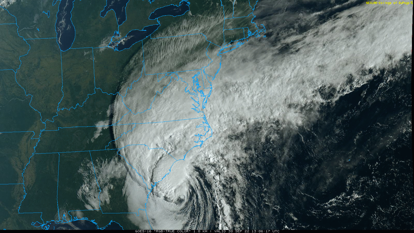
Those images almost remind me of the tragic flooding pics of Harvey in TX around the developments, although so far Ian hasn't reached the obscenely excessive levels of rain that Harvey produced as a cutoff 'caine that just meandered around SE TX sucking in GOM moisture, and depositing it beneath where it traveled. Will have to see how close it does get to that amount of rain though. Ian has slowed a bit from the last update per the 5 am -
-
It was definitely a change, although I expect a few days of "steam" from Ian before it moves on and the air gets scoured out again.
-
Interesting that you mention the Ukie because IIRC, the Ukie actually nailed (2017) Irma's track where it crawled along the northern coast of Cuba before it made its northward turn towards FL, so I know I try to keep the Ukie in my pocket for times like this.
-
Saw the exact same thing this evening. Called it an "Ian sunset" where a few of the separated furthest north bands were even visible from my vantage point! Was surprised, although perhaps shouldn't have been, that my high only got up to 66 today. The dp was also dry enough to start generating the "winter like" static electricity walking across the carpet here.. LOL It's currently 59 with dp 47.
-
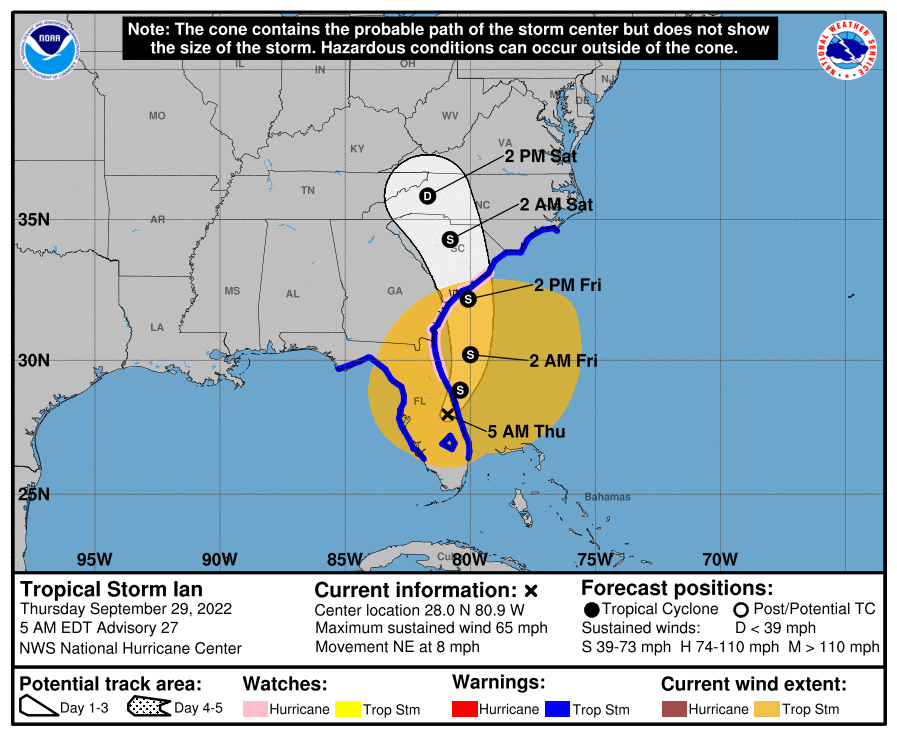
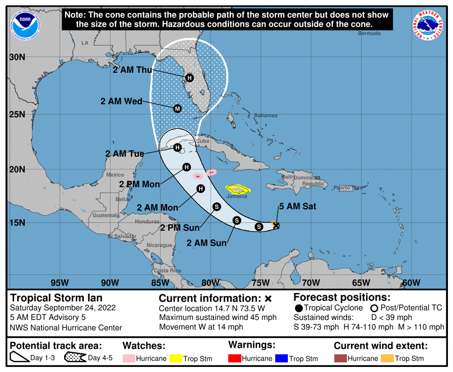
Ian was downgraded to a TS with the 5 am update - Looks like the buzz saw wants to fly off the coast, but slowly.
-
NHC's tweet with WPC's precip forecast - southern areas of the CWA will be getting fringed. I suppose what might make a difference is how long a duration is, including any wrap-arounds as the system exits and moves away from the east coast. Currently down to 50 about 10 minutes before sunrise with dp 47.
-
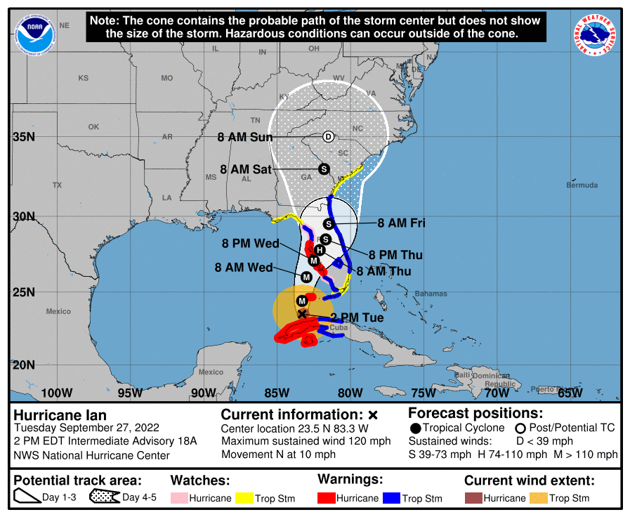
My Tues. high was 70 and yesterday's high a 68, after a low of 50. It's currently 51 with dp 47 and will be monitoring the track of what will be left of Ian as it is progged to get up here in some form or fashion this weekend and even as soon as Friday night. Ian was just downgraded to a tropical storm at the 5 am update and will soon exit FL. I know whatever comes up here is gonna have to fight some dry air. SPC's SWDY3 has the SE part of the CWA under "Marginal Risk" for severe -
-
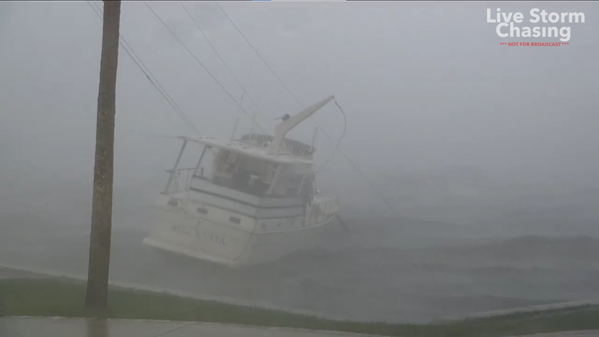
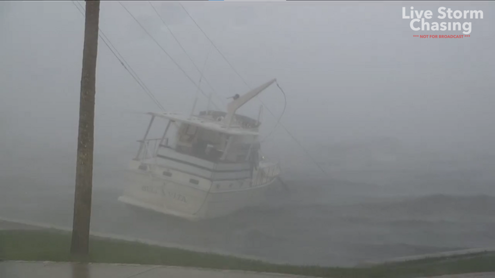
LOL figured Josh would be there. Am thinking that was the same boat that was on dry bed with some sailboats earlier today before the surge came and now it is hung up in some electric wires.
-
I've been watching some chasers all day and don't recall that kind of flooding. In fact they were showing all the blow-out tides. I did see pics/vids similar to that for Naples and Ft. Meyers. Punta Gorda is getting the heavy rains, flooding , and some surge in the low-lying/beach areas now.
-
Hurricane Michael at Mexico Beach had surge in that range up to about 14ft.
-
I remember trying to get out early from work when Gloria was blowing past. No luck. When I saw the track, I viscerally recalled it was either 2004 or 2005 when FL was the bullseye for so many 'canes and confirmed (and even saw a news item about it) how Ian is doing a path similar to the nasty little powerful Hurricane Charley from 2004. Charley did make landfall on some of the keys as a Cat 4. As an obs, I finished with a high of 75 yesterday and had a low of 51 this morning. The skies have been variable, with lots of cumulus, and it's currently a pleasant 69 with dp 48. (edit to add the 2pm track for Ian)
-
My eventual high yesterday was 74 before it clouded over and rained. I got a round 2 shot of 0.02" of rain between 10 - 11 pm making for a total of 0.45" for the day. Low so far this morning has been 54 and it's currently 56 and partly sunny with dp 56.
-
Got a sun shower and clearing incoming from the west, with another hundredth and 0.43" the tally so far with this event. Currently dark and cloudy to the east and mostly sunny to the west and 62 with dp 61.
-
I think the report was mostly focusing on California, which stays in almost perpetual drought and if anything, was an offer for something other than complete xeriscaping as they do in the more desert areas of the state (and adjacent AZ). I managed to pick up another 0.01" from the back edge for a total of 0.42" in this round (supposedly another possible round is due later overnight but we'll see). Currently 62 with dp 61.
-
Rain has mostly blown through now and just have some mist/drizzle. Picked up a welcome 0.41" from that round. Currently 61 with dp 60. Heard a KYW/CBS radio report talking about the drought (around the country) and how "Clover is the new lawn'". Don't really have to mow it (much) and you get your green plus you get the pollinators!
- 852 replies
-
- 1
-

-
- hurricane
- tropical storm
- (and 1 more)
-
Gully washer with >1.5"/hr rain. Currently have 0.22" in the bucket although I expect this may be a fast-mover. Currently 63 with dp 61.
- 852 replies
-
- 1
-
-
- hurricane
- tropical storm
- (and 1 more)
-
And EDIT - just had a loud clap of thunder.
-
And RAIN! (no convection with that yet)
-
Had a low of 58 this morning and so far it went up to 74 when the sun finally came out later this morning. But right now, it looks like armageddon outside with the sudden overcast and this on my doorstep! Will see if it can hold together for the couple miles that it is from me.
-
Had a final high of 64 yesterday and am sitting near my low for the morning of 46, with the last time it has been that IMBY, was back on May 9. Haven't completely decoupled and gone calm here but am close. Currently 47 with some scattered clouds and dp 39. Keeping an eye on TS Ian that recently formed (TD-9) and is aimed at FL.
-
Finally bottomed out at 51 this morning and it's currently 52 and partly sunny with dp below 40 for the first time in a long time, at 39!
- 852 replies
-
- 1
-
-
- hurricane
- tropical storm
- (and 1 more)
-
Some Frost Advisories lofted in a couple southern NY state counties across from NE PA. Mother Nature giving the signal to "get ready".
- 852 replies
-
- 1
-
-
- hurricane
- tropical storm
- (and 1 more)
-
I know you are ecstatic! Did finish with a high of 79 yesterday and right now have some scattered clouds around and temp here IMBY is 52, with the dp 43.