Hurricane Agnes
-
Posts
9,263 -
Joined
Content Type
Profiles
Blogs
Forums
American Weather
Media Demo
Store
Gallery
Everything posted by Hurricane Agnes
-
E PA/NJ/DE Spring 2023 OBS Thread
Hurricane Agnes replied to Hurricane Agnes's topic in Philadelphia Region
Had a low of 49 yesterday with a high of 68 (a bit warmer than I expected). But that front did a number on the dp overnight. Although the winds here have dropped compared to the breezy conditions yesterday, they haven't gone completely calm and there appears to be a high deck of cirrus, so that is going to impact any further radiational cooling. Currently 41 (and I expect I may possible drop a little more) with dp 27. -
E PA/NJ/DE Spring 2023 OBS Thread
Hurricane Agnes replied to Hurricane Agnes's topic in Philadelphia Region
One of the issues of 2002's drought was that I remember literally after 9/11, the fall and winter precipitation along the lower northeast/upper mid-Atlantic, was scant (this actually helped NYC to deal with the aftermath of the building collapses all winter). But I think to put it in perspective, we here in the east are thankfully nowhere near the southwest and southern west coast in terms of extended extreme drought conditions that for the first time in at least a decade, is being nipped. I just stumbled on this interesting analogous note about 2001/2002 and that season coming off what was also a 3-peat La Nina - https://science.nasa.gov/science-news/science-at-nasa/2001/ast06mar_1 Was also looking at the longer-term cycles like the PDO, where it has been in a negative phase - https://www.worldclimateservice.com/2021/09/01/pacific-decadal-oscillation/ And in comparison to the past 3 decades - (more granular data can be found going back to the 1850s - https://www.ncei.noaa.gov/access/monitoring/pdo/) Just some musings as the PDO is overlaying the ENSO and would need to do a deeper dive into it to see if anything is similar to 2001/2002. We had precipitation during the fall/winter 2022/2023 (although not in the form desired ) but it really did dry up almost completely in Jan/Feb 2002 (no measurable snow at KPHL that Jan), with a 95 temp in mid-April 2002 (helping to make it the driest Apr on record at the time), and worse, little or nothing in Jul 2002. So am hoping we don't get that dire this year. -
E PA/NJ/DE Spring 2023 OBS Thread
Hurricane Agnes replied to Hurricane Agnes's topic in Philadelphia Region
Yup - that happened here in the city too - 2002 was a real droughty year that also featured extended heatwaves that summer (dry begets dry). Remnants of Hurricane Isidore (which was a TS at U.S. landfall) helped to break it - -
E PA/NJ/DE Spring 2023 OBS Thread
Hurricane Agnes replied to Hurricane Agnes's topic in Philadelphia Region
It's happened before. And it caught a bunch of big box and standalone garden centers off guard because they had some of the tender annuals and veggies out and for sale and lost much of it because there was no space to jam it inside their small greenhouses (if they had any). After that, a number of them put up notices that they wouldn't offer things like tomatoes or cukes, etc., until after May 20 (or thereabouts). I usually wait until around Memorial Day to put out my potted tropicals (I have my subtropicals out now though).. Made it up to 75 today after a low of 54 and the significant dp drop came sometime between 1 am - and 2am around these parts. Definitely made a difference today with a nice breeze to boot. It's currently 66 with dp 37. -
E PA/NJ/DE Spring 2023 OBS Thread
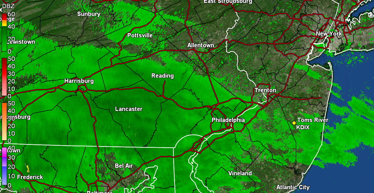
Hurricane Agnes replied to Hurricane Agnes's topic in Philadelphia Region
I was actually surprised it even showed returns up this far north as it had originally been progged for the Delmarva. I so still only got a hundredth of an inch but it was still enough going much of the day to wet the streets and walks and plants. I finally got a bucket tip between 1 - 2 pm (radar snapshot below). The line from the cold front is very slowly sagging south but the dews are still up (64 here with temp 70) so it hasn't moved through.
-
E PA/NJ/DE Spring 2023 OBS Thread
Hurricane Agnes replied to Hurricane Agnes's topic in Philadelphia Region
Have been getting barely measurable light rain most of the morning and into the early afternoon. The bucket finally tipped at only 0.01" so far but will take it at this point. Had a morning low of 67 this morning and it managed to get to 73 before dropping back to the current 69, with a somewhat elevated dp of 62. -
E PA/NJ/DE Spring 2023 OBS Thread
Hurricane Agnes replied to Hurricane Agnes's topic in Philadelphia Region
Well I hit 87 for a high @1:45 pm and then it clouded over a bit but has since cleared. Currently a partly cloudy 84 with dp 53. Am hoping some of that Delmarva rain creeps up here tomorrow. -
E PA/NJ/DE Spring 2023 OBS Thread
Hurricane Agnes replied to Hurricane Agnes's topic in Philadelphia Region
Had a high of 81 yesterday after a 66 low and bottomed out at 56 this morning. Have so far briefly tapped 85 about quarter after 12. It's currently a somewhat hazy and partly sunny 84 with plenty of high clouds, and a dp at a not-quite-oppressive-yet 56. ETA to note that I started putting my overwintering subtropical potted plants out but am not quite ready to do the tropicals since they don't like anything below the 50s at night. I usually wait until around Memorial Day for those anyway although the long range seems to suggest I could put them out now (but I don''t want to chance any sneaky 40s between now and the end of the month). -
E PA/NJ/DE Spring 2023 OBS Thread
Hurricane Agnes replied to Hurricane Agnes's topic in Philadelphia Region
Bottomed out at 46 this morning and made it to 72 as a high. Currently a hazy 67 with a deck of high clouds, and with dp a low 41. -
E PA/NJ/DE Spring 2023 OBS Thread
Hurricane Agnes replied to Hurricane Agnes's topic in Philadelphia Region
Ended up with double 7s for a high, 2 days in a row, although this morning, my low was a warmer 59, almost 10 degrees more than yesterday's low... plus there were more clouds early on before they cleared out. It's currently partly sunny and 74 with dp 50, so a really nice and comfortable mid-spring day. -
E PA/NJ/DE Spring 2023 OBS Thread
Hurricane Agnes replied to Hurricane Agnes's topic in Philadelphia Region
Bottomed out here at 50 just after 6 am (not long after sunrise). "Chamber of Commerce" day yesterday and so far today with mostly blue skies and few clouds. Have been sweeping the patio so I can put out a small replacement outdoor rug, and doing some other clean up and pruning. Currently 72 and mostly sunny with dp 51. -
E PA/NJ/DE Spring 2023 OBS Thread
Hurricane Agnes replied to Hurricane Agnes's topic in Philadelphia Region
My high yesterday ended up being 61 and I bottomed out at 43 this morning. The day started out sunny but the threatening clouds did roll in as the popcorn got started but haven't been under any pop ups today so far. In any case, I topped out at 65 and am currently mostly cloudy, with peaks of sun, and 57 with dp 50. -
I was a sophomore in college when that happened and I had my B&W Zenith portable in the dorm. At home we also had a 12" Panasonic portable B&W but there was the one 19" Zenith color in the living room. That one had been a replacement for an old RCA color console from the late '60s. I think in '84 my mom finally got a Zenith with a remote, so no longer had to respond to barked commands of "Turn to 6...", "Change to 3...", "No go back to 6!"
-
E PA/NJ/DE Spring 2023 OBS Thread
Hurricane Agnes replied to Hurricane Agnes's topic in Philadelphia Region
Bottomed out at 42 this morning and made it up to 54 before some heavier clouds and light precip came (with 0.01" registered) to put a damper on things. My Wyndmoor sis texted a little over an hour ago that she was getting "sleet". I saw there were some reports in suburban Philly of hail so am thinking she either had tiny hail (less than pea size) or possible some graupel. I only got rain drops here at that time and the temp was 50. Currently overcast and 49 with dp 44. -
E PA/NJ/DE Spring 2023 OBS Thread
Hurricane Agnes replied to Hurricane Agnes's topic in Philadelphia Region
Had a low of 44 this morning and noticed I got 0.03" of rain on either side of midnight between yesterday and today (total 0.06" for the 2-days so far). Currently overcast, misty and 46 with dp 42. -
E PA/NJ/DE Spring 2023 OBS Thread
Hurricane Agnes replied to Hurricane Agnes's topic in Philadelphia Region
Had been waiting for the updated PNS (the last version was from this past Saturday) and the totals were impressive. All 3-day - -
E PA/NJ/DE Spring 2023 OBS Thread
Hurricane Agnes replied to Hurricane Agnes's topic in Philadelphia Region
Yeah, last year I had 55.91 total liquid precip in the bucket (although that would include snow/IP melt as well). Well the strange yellow orb in the sky that has been in and out all day is "in" at the moment and it's currently 60 with dp 40.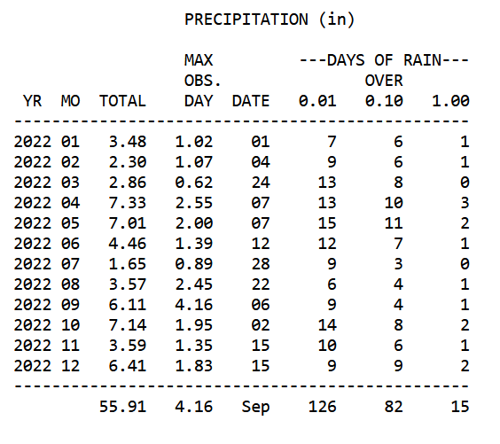
-
E PA/NJ/DE Spring 2023 OBS Thread
Hurricane Agnes replied to Hurricane Agnes's topic in Philadelphia Region
OMFG I went to bed during some moderate showers with 1.02" in the bucket and didn't expect the death band to pivot over me but it apparently did. I ended up with another 1.19" on top of that, finishing up with 2.21" for the day. Literally, the last 5 days have now given me 5.01" of rain. Just last week I wrote this - AND April 2023 has now literally beat April 2022's monthly total by 0.21" and I closed out with 7.54". Was surprised that the temp crashed though. Eventually had a high of 61 yesterday. Currently 49 and misty with some low stratus and dp 42. Wissahickon is up but probably would have been worse had it not been as dry earlier in the month.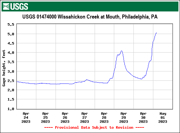
-
E PA/NJ/DE Spring 2023 OBS Thread
Hurricane Agnes replied to Hurricane Agnes's topic in Philadelphia Region
Was getting ready to say... I was wondering if you were under that fire hose that formed or were getting shafted on either side! -
E PA/NJ/DE Spring 2023 OBS Thread
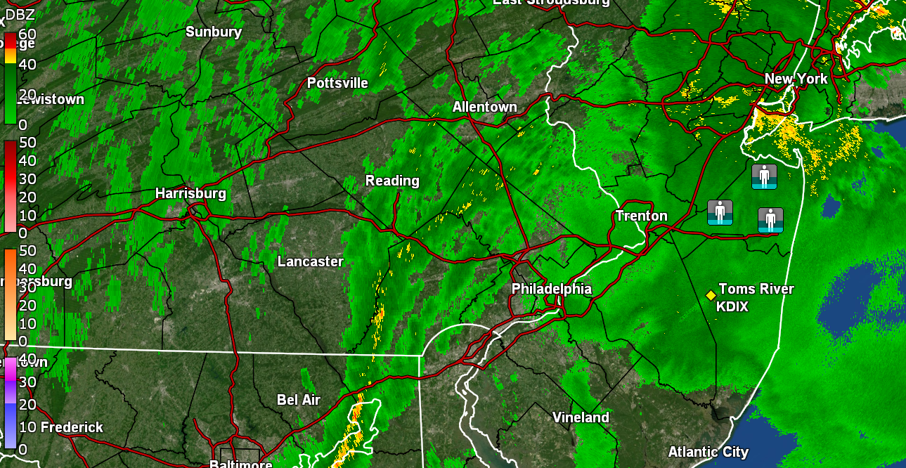
Hurricane Agnes replied to Hurricane Agnes's topic in Philadelphia Region
Checking in and currently misty with the temp slowly rising and at 60 with dp 60. Now have 0.87" in the bucket and saw on the radar an interesting "line" (precip has been pushing up from south to north).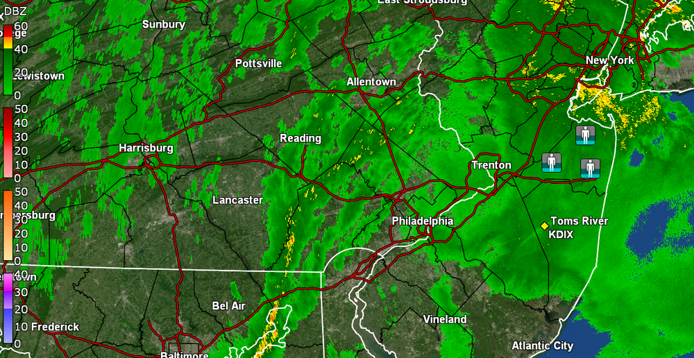
-
E PA/NJ/DE Spring 2023 OBS Thread
Hurricane Agnes replied to Hurricane Agnes's topic in Philadelphia Region
Am under a moderate rain band, varying between about 1/3" - 1/2" per hr rates. Currently have 0.82" for the day at post time with temp 56 and dp 55. -
E PA/NJ/DE Spring 2023 OBS Thread
Hurricane Agnes replied to Hurricane Agnes's topic in Philadelphia Region
SPC SWDY1 pushed the "Marginal Risk" line up a touch further north within the southern part of the CWA vs yesterday's SWDY2 outlook - Mt. Holly tweeted out the precip tracking from yesterday's PNS with rainfall totals - Light rain has actually started here this morning despite the expectation/hope it would be "dry" for the Broad St. run. Currently have 0.11" in the bucket and it's 53 with dp 52. -
E PA/NJ/DE Spring 2023 OBS Thread
Hurricane Agnes replied to Hurricane Agnes's topic in Philadelphia Region
With the all-day drizzle, drips from that accumulated enough to tip the bucket a few more times for me to end up with a 0.99" total for Saturday, for a final of 2.22" the past 2 days. Also topped out at 57 yesterday for a high. I had noticed last night that the low stratus had started rolling in and this morning I have fog with vis. < 1/10th of a mile, a temp of 52 and dp 51. -
E PA/NJ/DE Spring 2023 OBS Thread
Hurricane Agnes replied to Hurricane Agnes's topic in Philadelphia Region
Back edge of round 1 is moving away and I picked a couple hundreds more inches for 0.96 today (so far) and 2.19" 2-day total. Still overcast and misty, with an earlier low of 48 and current temp of 54 with dp 54. SPC SWDY2 has the southern part of the CWA (Delmarva and Lower South Jersey) under a "Marginal Risk" for severe and the rest for poss. t-storms - -
E PA/NJ/DE Spring 2023 OBS Thread
Hurricane Agnes replied to Hurricane Agnes's topic in Philadelphia Region
Ended up with 1.23" of rain yesterday and woke up to 0.91" between midnight and 4 am. The 2-day event total is 2.14" so far. Currently a breezy, raw, misty, and overcast 49 with dp 49.