Hurricane Agnes
-
Posts
9,344 -
Joined
Content Type
Profiles
Blogs
Forums
American Weather
Media Demo
Store
Gallery
Everything posted by Hurricane Agnes
-
The ground is dry so that it enhances any radiational cooling, like you see in naturally dry areas or the desert! I remember being on a training trip to Colorado over 30 years ago in August and how it would get up to the 90s during the day but drop down to the 40s at night. That was somewhat expected being a mountain climate but the thermodynamics was on display. I bottomed out at 51 and am currently clear and 53, with a very high thin deck of clouds, and dp 50.
-
Was hoping you were in the path of that - at least for the rain potential!!!! Looks like most of it is moving south but to the far west of me so I don't think I'll get anything. So far it appears the cold front has been oozing in here with overcast skies as I did reach a high of 76 earlier today but am now down to 65 with dp slowly starting to drop, and now at 57.
-
Bottomed out at 66 this morning with bright sunshine, but that has now faded behind a deck of clouds. The 0.01" reported yesterday (which was barely enough to wet a few sidewalk blocks) was it. Currently overcast, breezy, and 72 with a dp of 62, and you can definitely feel the humidity.
-
Am right on the northern edge of a new Warning.
-
Got enough to tip the bucket for 0.01" and drop the temp to 78. Dp is now up to 65.
-
Getting some thunder and by golly, some RAIN!!!
-
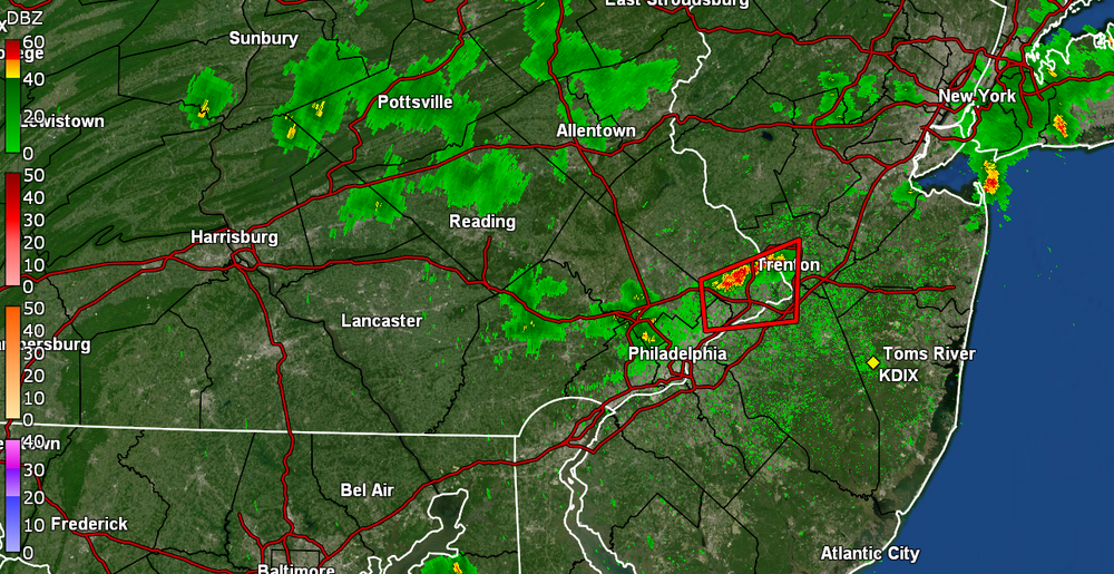
Severe Thunderstorm Warning up for Bucks/NE Philly.
-
I turned mine on about 1 pm yesterday and decided to leave it on overnight so I can keep the bricks cool for when the the sun started blazing today. I have actually crept back up to 90 once the clouds moved on, with dp still 60. Looks like Paul might get some from a couple pop-ups headed that way.
-
Glad to see some of you up north cashing in on the pop-ups. They appear to be moving from NE -> SW. I also noticed that a seabreeze front has been steadily moving from E-> W and is almost at the Delaware River. I did hit 95 for a high today but it clouded over and is still generally cloudy with some sun shining through it, and a temp earlier down to 88, but now ticked up a notch to 89, with dp 59. I also saw that the first TS of the season has arrived - Arlene, which is down in the Gulf but drifting south.
-
E PA/NJ/DE Spring 2023 OBS Thread
Hurricane Agnes replied to Hurricane Agnes's topic in Philadelphia Region
Some stuff is popping (got some dark clouds) showing up to the west. My lightning detector picked some confection almost 20 minutes ago And I actually hit 95 just after 3:30 pm and then it started clouding up. Currently 93 with dp 60. And yeah, the humidity is 33% here but it is still blast-furnacey here.
-
E PA/NJ/DE Spring 2023 OBS Thread
Hurricane Agnes replied to Hurricane Agnes's topic in Philadelphia Region
And just hit my first 90 of the season just after noon today. It's currently mostly sunny and 90 with dp bopping between 60 & 61 (not a good combo). -
E PA/NJ/DE Spring 2023 OBS Thread
Hurricane Agnes replied to Hurricane Agnes's topic in Philadelphia Region
I agree! I watched during the 17-year lifespan of one of my nieces, as 2 brand new schools (Erdenheim Elementary and a brand new replacement Enfield Elementary) were built from the ground up in her township (Springfield, Montco) and that township has a population of 20,000 (from 4 towns). Meanwhile here in Philly... It doesn't bode well for "year round school" being proposed (and possibly piloted soon) unless they only do it in facilities that can handle it. In any case, I have bottomed out at 62 this morning and am on the way up, so will see how warm it gets before the frontal passage. Currently partly sunny and 64 with dp getting into the uh oh range at 59. -
E PA/NJ/DE Spring 2023 OBS Thread
Hurricane Agnes replied to Hurricane Agnes's topic in Philadelphia Region
Looks to be a "pulsing" of warm/cool/warm/cool like a heartbeat, over the next 10 days.
-
E PA/NJ/DE Spring 2023 OBS Thread
Hurricane Agnes replied to Hurricane Agnes's topic in Philadelphia Region
That's because of all the piece-o-junk century old (or more) buildings that have no A/C. And yeah, back in the day, kids suffered in those old buildings with one of those giant pedestal fans with the windows open, lights out, and bees flying into the classroom, but I expect the teachers, staff, and parents complained - especially if some got heat stress or even heat stroke from it. Some schools are "newer" (in quotes) and have central air and other schools finally got some window units but the bulk still don't have them because the old electric circuits can't handle the amps for an AC in each classroom. So the 90 schools aren't "all" of them but are the ones that have no air. They apparently have a policy for closures for those schools if the temps are forecast for 90s and above (where inside the brick and masonry building, the temps can soar to 100+).. -
E PA/NJ/DE Spring 2023 OBS Thread
Hurricane Agnes replied to Hurricane Agnes's topic in Philadelphia Region
Wow. Didn't expect that we would break the record for a dry May. And Reading's May 2023 is now 2nd driest month on record, period. Drought monitor also filling in - I ended up with a low of 55 this morning and hit 87 for a high. Thankfully the humidity has been reasonable. Currently partly sunny and 84 with dp 53. -
E PA/NJ/DE Spring 2023 OBS Thread
Hurricane Agnes replied to Hurricane Agnes's topic in Philadelphia Region
Another pleasant day today with relatively low humidity, a cooler low this morning (compared to the last couple days) of 49 and a warmer high of 79. Expect that to change the next couple days. When I was out watering, I didn't see/smell any smoke here, although I admittedly wasn't sitting outside all day either. It's currently partly sunny and 75 with dp 54. -
E PA/NJ/DE Spring 2023 OBS Thread
Hurricane Agnes replied to Hurricane Agnes's topic in Philadelphia Region
I saw Mt. Holly had tweeted this earlier - -
E PA/NJ/DE Spring 2023 OBS Thread
Hurricane Agnes replied to Hurricane Agnes's topic in Philadelphia Region
Yup and that meant extended bouts of 90s because the sun didn't have to "waste energy" evaporating ground moisture and just fires up the ground and air. I heard Matt Brudy (Mt. Holly NWS) on KYW this afternoon and he mentioned PHL has only registered 0.24" of rain for the month. There is still a little ground water reserves from the end of April deluges but that will eventually drain away and of course the ground surface is now bone dry as all the precip gets suppressed to the south. I bottomed out at 54 this morning and hit 75 for a high. Air Quality Alert was lofted but I didn't realize that this Canadian wildfire smoke is going to be coming from the east coast (Nova Scotia) vs further out west that has been getting hit hard and sending it this way (Alberta). https://www.npr.org/2023/05/30/1178918224/canada-nova-scotia-wildfires-evacuations -
E PA/NJ/DE Spring 2023 OBS Thread
Hurricane Agnes replied to Hurricane Agnes's topic in Philadelphia Region
Was at my Wyndmoor sister's house yesterday for grilling and it capped off one of those rare nice Memorial Day holiday weekends as there was often a tendency for some kind of rain on any of the 3 days in the past. Her spot is a great lightning bug habitat with a little creek at the bottom of the property but none were out yet (she said she tends to see them by around June 10). After another 50 low yesterday, I made it up to 77 IMBY with mostly calm winds. This morning's low was a warmer 58 and it shot up to 82 for a high before the easterly breezes kicked in and dropped me down to a current partly sunny 72 with dp 52. I am still holding at 0.31" of rain for the month. Had pulled out the hose to do a good soaking this past Thursday but may have to come back around again before the heat up later this week. -
E PA/NJ/DE Spring 2023 OBS Thread
Hurricane Agnes replied to Hurricane Agnes's topic in Philadelphia Region
After another 50 low this morning, I got up to 79 for a high today and dry conditions aside (and the hose will have to get a workout), you couldn't ask for a better day in terms of lack of humidity. Currently mostly sunny and breezy with a few clouds here and there, and 77, with dp bopping between 41 - 43 and humidity between 28 - 30%. -
E PA/NJ/DE Spring 2023 OBS Thread
Hurricane Agnes replied to Hurricane Agnes's topic in Philadelphia Region
Bottomed out at 50 this morning and made it to a pleasant 74 as a high, with an oddly "cool" breeze. I threw caution to the wind and put my overwintering potted tropical plants out for the summer given the upcoming week's forecast. This time last year we had similar temps although I ended up soaring to a high of 95 on 5/31/22. I know some of the guidance has suggested some kind of warm-up next week with a potential for mid-upper 80s or maybe a 90, but we shall see. It's currently a partly cloudy 71 with dp 41. -
E PA/NJ/DE Spring 2023 OBS Thread
Hurricane Agnes replied to Hurricane Agnes's topic in Philadelphia Region
My low yesterday was 47 and high was 82 and I shockingly got 0.01" of rain - which was not expected since the rain from the front was pretty diffuse. In fact, just after midnight, I got another 0.01" out of nowhere so have a total of 0.02" from the anemic 2-day event and so far 0.31" for the entire month of May. Currently 51 and somewhat hazy with dp 43. -
E PA/NJ/DE Spring 2023 OBS Thread
Hurricane Agnes replied to Hurricane Agnes's topic in Philadelphia Region
Monday I finished up with a high of 80 after a low of 54, with today's high and low a little cooler @ 53 and 74. Currently have a thick deck of hazy cirrus up above where the sun is still managing to shine through it. Temp is 72 with dp 51. -
E PA/NJ/DE Spring 2023 OBS Thread
Hurricane Agnes replied to Hurricane Agnes's topic in Philadelphia Region
Made it up to 77 today after a low of 55. When I went to bed last night, the broken precipitation line ahead of the front was incoming and by early this morning, the line had solidified, but not until after it hit New Jersey (and eventually reached the coast). So as as a result, I only picked up 0.03" from it (2-day total was 0.21"). I'll have to settle for that. Currently 64 with dp 53. -
E PA/NJ/DE Spring 2023 OBS Thread
Hurricane Agnes replied to Hurricane Agnes's topic in Philadelphia Region
Had a low of 54 this morning and seemed to have been at the western edge of the precipitation shield. So far, with the on and off dribbling, I have 0.18" in the bucket and I'll take it at this point. Am currently at my high of 67, with dp a sticky 67, and the sky seems to want to brighten some.