

Hurricane Agnes
-
Posts
9,343 -
Joined
Content Type
Profiles
Blogs
Forums
American Weather
Media Demo
Store
Gallery
Everything posted by Hurricane Agnes
-
There were a couple TORs over around York but I don't know if anything was confirmed. I've been getting that "tropical storm" type clouds, but nothing has bubbled up here. I'll be happy with 1/4" if I can get it. Have been watching the clouds advecting in from the southeast now... and it's a soupy 86 with dp 74, so I the 90.0 was my high for the day. Have been watching that track of Henri too.
-
Damn. Didn't expect to hit 90 today, but I just did (#31 since May) - although the sun did make a more extended appearance earlier this afternoon right before I got there and then executed a self-destruct. Currently 88 when it clouded over with dp 75.
-
Tornado Watch up for northern/western parts of the area -
-
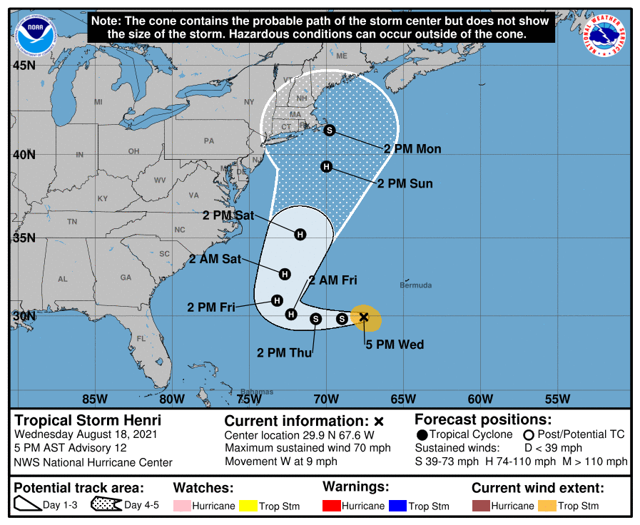
Getting closer and closer to the 40/70 benchmark. ETA - Levi Cowan's take -
-
Despite the cloud cover and attempts at the sun trying to break through but not quite making it out, the temp has soared a bit more than I expected. So far the high here hit 87 but it's currently mostly cloudy, with a few breaks in the ceiling, and 86, with a disgusting dp of 77.
-
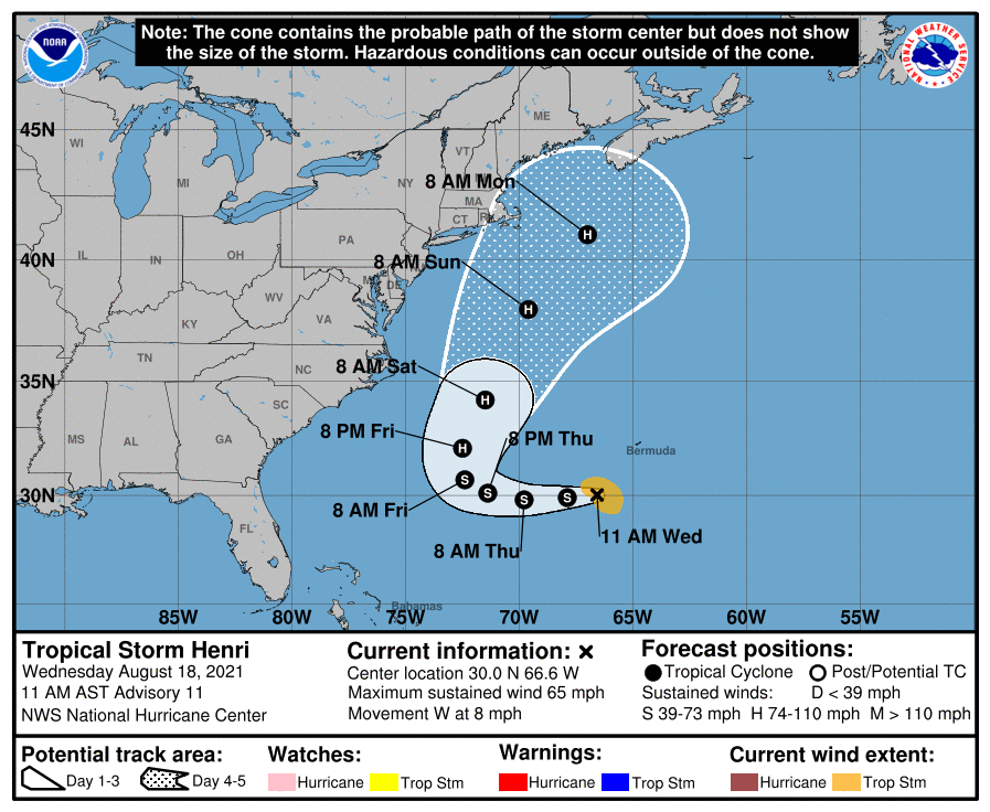
LOL I have been watching the track change further and further west before the N/NE direction change the past couple days. It was originally progged to do a tight loop around Bermuda and out to sea but each subsequent update has it moving more and more westward before making the turn. In any case, I've been getting on and off stratus this morning along with the general overcast. Low this morning was 74 and it's currently 77, with dp 75.
-
Getting some light rain coming up from the south. It just reached the level to be enough to tip the bucket with 0.01" after wetting the walks. Temp is currently 79 with dp 74.
-
So far had a low of 71 and high of 83 today, but with the changeable skies (mostly overcast), the temp has understandably fluctuated. It is definitely feeling more humid out though and it's currently 82 with dp 71. Need a little rain here now. Have been looking at what appears to be subsidence just drying up the metro I95 corridor, with a band of showers to the south in MD and DE and a scattered band that shifted from the Lehigh Valley and Poconos, to the far north near the PA/NY border.
-
After a low of 70 this morning, I did manage to make it to 83 for a high, but the humidity is back. Had run to the supermarket this morning and it was definitely noticeable. The sun was in and out earlier but it's been generally overcast most of the afternoon. Currently 79 with dp 68 and overcast.
-
Made it up to 84 today with amazing "low" humidity for August - only in the mid-upper 30% range. Currently 82 and mostly sunny with some cirrus advecting in and a dp of 55.
-
Watched the radar as the front started moving through between 4 am - 5 am, although the returns evaporated, so didn't get any precip from it. However saw the dp drop from ~71/72 down to the current 59, which is pretty dramatic. Temp was in the low-mid 70s and did a corresponding drop with the front crossing, and is now down to 68 at post time, with a deck of clouds overhead. I saw that further west of here in central/western PA, the current temps are in the mid-50s. ETA (1 hour later) - I got chance to pop out to the back and saw the plant foliage had been wet and was drying, although whatever came through this morning was not enough to tip the bucket. Still I'll take it.
-
Wasn't sure if I would do it, but after a low of 73 this morning, I did tap 90 just before noon today (#30 of 90+ since May). It's currently 89 and partly cloudy with dp bopping between 72 and 73. SPC has our area in a "Marginal Risk" (but hope I can get a little rain in to top off after the past couple days of heat).
-
Looks like the 96 was my high and I'm now getting some incoming clouds but am still partly sunny and "down to" 92, with a dp 71.
-
Have now hit 95 (although still haven't matched or exceeded my highest of the summer yet, which was 96 on 6/30/21). The few earlier wispy clouds have disappeared and now have all blue sky. Dp is 70. Some stuff has been firing west of Harrisburg the past couple hours.
-
Have already hit a 90 just after 10:30 this morning (#29 since May), with a low of 74. Am currently @90 with a mixed-out dp of 69 (much better than the mid-upper 70s earlier this week, which probably also included "burning off" the moisture from the antecedent rain at that time). May hit the mid-90s earlier today but will see.
-
Was figuring someone would cash in. I didn't, which is fine since I got something the previous 2 days. Currently much warmer this morning (so far) than the previous mornings this week and at 76, with dp 71.
-
I don't even bother looking for the annual meteor showers around here anymore. It's always either rainy or some deck of high clouds suddenly appear to block the sky. Thankfully i got chance to see the Perseids during an August work trip in Colorado about 35 years ago (at ~8200 ft altitude where the lodge was). The whole sky there was literally awesome at night. "Dark sky" was a misnomer because it was all Milkway and everything else, with a sprinkle of continual Perseids. I did pop out to see what will be a setting crescent moon in a pretty clear sky though. The critters are making a racket and the katydids are officially here making more noise than the crickets. Temp is "down to" 84 with dp 74.
-
Jinxed! Something did just bubble up around State College though. For all we know, if that line makes it over the mountains, it might be a 3 am fireworks show.
-
Looks like my 95 was it for the high and I'm down to 89 wih dp down to 72. Radar is still clear so I guess the past couple days took all the moisture out of the air and with today's "dry", it may actually get a little hotter tomorrow since there shouldn't be as much energy needed to remove the ground moisture this time (unless something forms overnight). There is a blob and line of convection back over Pittsburgh but that looks like it may take some time to get here.
-
Based on the past couple days being analogs, that means you'll be flooding. Temp so far has hit 95 as a high and currently 95 and mostly sunny with dp 76.
-
When all was said and done, I ended up with 0.25" from that line yesterday, which is fine. The low this morning was 71. Currently have blue sky to the south and some hazy high clouds to the north and 84, with dp 75. If it is going to hit mid-upper 90s here today, then it needs to already be close to or in the low 90s here by now, but we shall see.
-
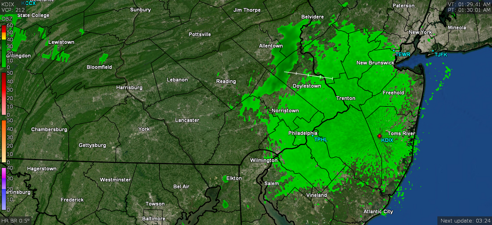
Yeah, what is with this late-ass thunder? There was nothing as it came through and now like 45 minutes later, we're hearing I guess what is the rocking and rolling going on in Jersey. As a note, my BIL and one of his buddies went to see the Phillies last night and I told my sis that they had to have been in a rain delay because there was a huge blob sitting right over the stadium area. I think it was a delay for something like 90 minutes. They probably should have just given up at that point considering what happened when they resumed.
-
Well so far, I got 0.22" out of it which is fine since I already got 1.68" yesterday. So a good top-off ahead of the torch the next couple days. The rain did drop the temp to 75 and the dp "down to" 73. Still getting some light rain.
-
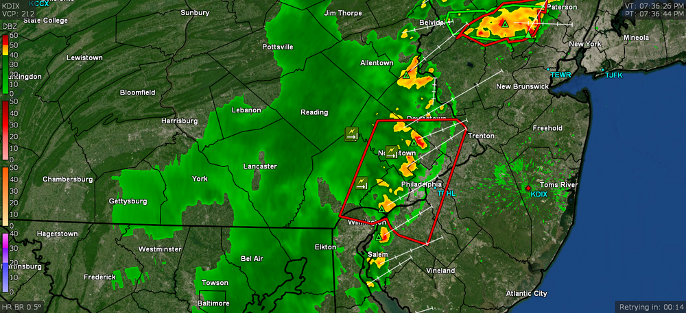
And it reactivated over the hot streets and a blob just blew up over me. Getting heavy rain now.
-
It's fizzling as it goes over the Montco hills. Starting to get some rain now (0.01" so far). Temp is down to 81 with dp 72.


