Hurricane Agnes
-
Posts
9,264 -
Joined
Content Type
Profiles
Blogs
Forums
American Weather
Media Demo
Store
Gallery
Everything posted by Hurricane Agnes
-
E PA/NJ/ DE Winter 2021-22 OBS Thread
Hurricane Agnes replied to JTA66's topic in Philadelphia Region
Still nada here, not even a flake. Looks like it has mostly dissolved. Currently overcast and 38 with dp 28. -
E PA/NJ/ DE Winter 2021-22 OBS Thread
Hurricane Agnes replied to JTA66's topic in Philadelphia Region
My sis in Upper Darby just texted that it was snowing where she is. Am not seeing anything here in NW Philly yet but looks like something might be incoming soon. Currently overcast and 37 with dp 27.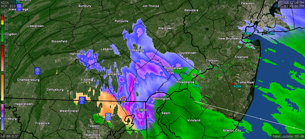
-
E PA/NJ/ DE Winter 2021-22 OBS Thread
Hurricane Agnes replied to JTA66's topic in Philadelphia Region
Some stuff incoming although the temps here IMBY are marginal at the surface (currently 35 with dp 26). It was partly cloudy earlier but it is clouding up some now. As a note, I made it up to 52 yesterday after a low of 36.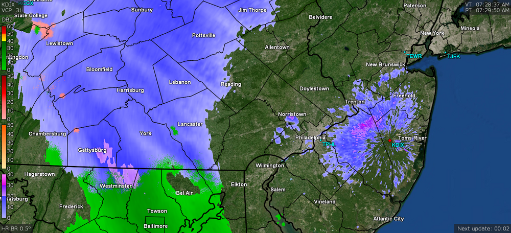
-
E PA/NJ/ DE Winter 2021-22 OBS Thread
Hurricane Agnes replied to JTA66's topic in Philadelphia Region
'Nuff said! The above is an excellent news summary (and obviously PR piece from PGW) about that winter. The year of the long johns too and where wool sweaters/socks and puffy down coats and vests became a thing. I remember after that and the next couple winters, we ended up getting a kerosene heater (and had found a gas station not too far away that sold kerosene). -
E PA/NJ/ DE Winter 2021-22 OBS Thread
Hurricane Agnes replied to JTA66's topic in Philadelphia Region
Ehh... it was a typical Bing Crosby WW2 musical thing. They contrive a plot with buddies who are performers who eventually attempt to revive/open an entertainment venue. It was a nod to Crosby's "Holiday Inn" (which released 12 years earlier), where the songs "White Christmas" and "Happy Holidays" actually debuted. Some of the quips in the movie reminded me of our little group though, including one where Crosby saunters up to the lodge desk clerk and starts a conversation with "We came up here for the snow. Where're you keeping it?" and she replies "Well we take it in during the day". Ugggghhh... and I was on SEPTA to get to/from high school and living here with the hilly streets meant either no buses showed up and/or showed up but were packed to the point that people were smashed against the doors and it had to bypass my stop and/or we would have to get off and walk up to the top of hills along the route, and then get back on once there because the bus couldn't make it without sliding back down. That was the year of the glacial streets and walks. I know our ice chopper got much use and the station wagon had to use chains a few times. The temps here have been wavering with the warm front and have gone up and down (high for the day appears to have been 54, assuming the non-diurnal warming is done for now) and am currently getting a round 2 of very light, with temp at 52 and dp 50. Picked up 0.05" earlier and am now up to 0.07 with this latest round. -
E PA/NJ/ DE Winter 2021-22 OBS Thread
Hurricane Agnes replied to JTA66's topic in Philadelphia Region
I finally decided to watch the above movie for the first time last week and LOL'd at the plot of a pair of former WW2 buddies who became big time entertainers after the war and ended up meeting and following a pair of sisters (also performers) who were heading to a Vermont Ski Lodge (later found to have been owned by the guys' old WW2 CO) right before Christmas for their next engagement. Upon arrival, they all thought they had boarded the wrong train (musing about whether they were in North Carolina instead) because there wasn't a flake of snow anywhere in the area. In Vermont. In late December. The laments sounded like those here, although for Vermont, that would have been a righteous outrage. It did eventually snow right on queue. Hope everyone has a wonderful Christmas and winter holiday. Currently light rain and 41 with dp 40. -
E PA/NJ/ DE Winter 2021-22 OBS Thread
Hurricane Agnes replied to JTA66's topic in Philadelphia Region
That was the awful season of the ice storms - I recall counting 17 in all. The entire tri-state area had run out of salt - both road salt and consumer halite. They eventually had convoys coming down from NY to provide some for the road crews. People were down to putting sand (if they had any) or kitty litter out. I actually had to go on a work trip to Baltimore (via Amtrak) during one of them and drove to 30th St. Station (parked there for a few days) literally just as the latest storm was underway. I was about to go on the Schuylkill Expressway to eventually get to 30th St. figuring PennDOT would be keeping that cleared but decided to go past it instead and took one of the river drives into the city. Thankfully I did because they eventually closed the Expressway and people were trapped there for at least 8 hours. When I finally got to Baltimore, I was able to find a couple bags of salt and brought them back with me in my suitcase for my mom. She ended up being the only one on her block the rest of the winter with her sidewalk clear and dry to the pavement. Currently partly cloudy out and 40 with dp that has gradually crept up to 36. -
E PA/NJ/ DE Winter 2021-22 OBS Thread
Hurricane Agnes replied to JTA66's topic in Philadelphia Region
I thought this Mt. Holly tweet was a hoot - I do know with marginal temps even down where I am, north of here with that precip will mean some icy roads. Just heard on KYW traffic report that Jersey was starting to treat the roads (most likely up in the north). -
E PA/NJ/ DE Winter 2021-22 OBS Thread
Hurricane Agnes replied to JTA66's topic in Philadelphia Region
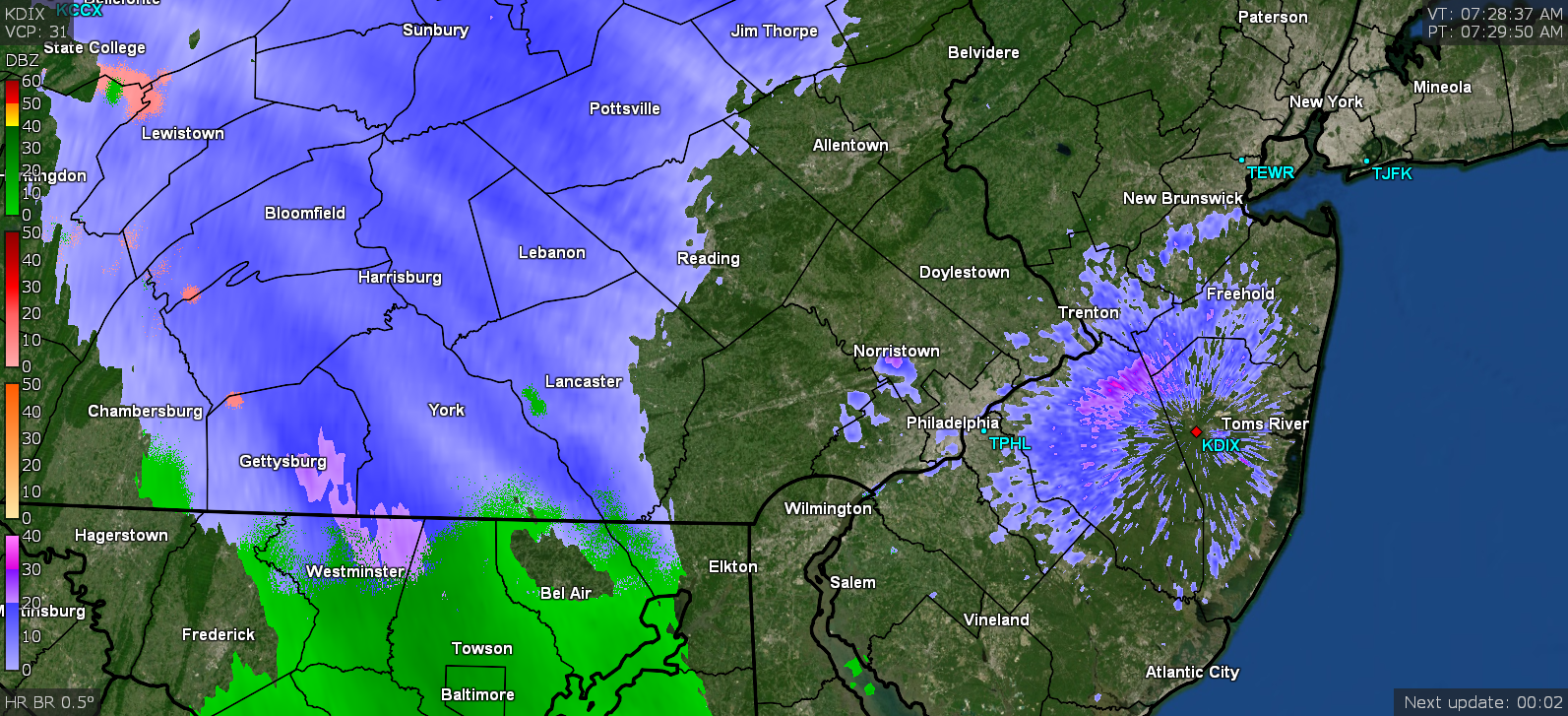
Dusting out there on the coldest surfaces (mainly cars). Seems the heaviest here may have been around 2:45 am. Currently 33 with dp 24.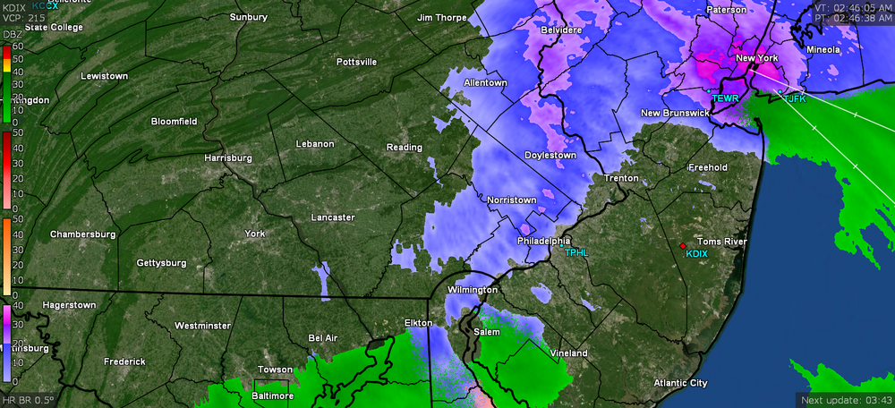
-
E PA/NJ/ DE Winter 2021-22 OBS Thread
Hurricane Agnes replied to JTA66's topic in Philadelphia Region
Back-loaded winter. I know we have had frosts as late as the 3rd week of May. -
E PA/NJ/ DE Winter 2021-22 OBS Thread
Hurricane Agnes replied to JTA66's topic in Philadelphia Region
I had saved my old sig line and had this - Biggest event was 1/18/20 with 1.20" IMBY. Total was 2.47". I did make it up to 45 for a high today and it's currently 37 with the dp crashing through the day and now down to 20. -
E PA/NJ/ DE Winter 2021-22 OBS Thread
Hurricane Agnes replied to JTA66's topic in Philadelphia Region
My low this morning was 34 but am still hanging in the 35 range. Got 0.01" late last night and another 0.17" deluge this morning for a total of 0.18" for the event. Currently 35 and clearing with sun peeping out and dp 34. -
E PA/NJ/ DE Winter 2021-22 OBS Thread
Hurricane Agnes replied to JTA66's topic in Philadelphia Region
I know you guys know about this but a well-placed SSW event that breaks up the PV is one variable that can trigger a change. There was a nice discussion about the one that happened last January here - https://www.climate.gov/news-features/blogs/enso/sudden-stratospheric-warming-and-polar-vortex-early-2021 I haven't had chance to dive into the current placement of systems at the moment, but conditions that would make that circumstance more favorable were noted in that discussion - I'm thinking that nothing has really been "persistent" because the northern (PAC) jet has been progressive and moving things along fairly rapidly. Interestingly enough, there was a significant SSW over the Antarctic back in 2019 that was analyzed and discussed - https://news.mit.edu/2021/how-sudden-stratospheric-warming-affected-northern-hemisphere-0722 But as rare as that type of event is in the Antarctic in comparison to the ones that happen in the Arctic, apparently another SSW was underway AGAIN in the Antarctic this past August - https://www.severe-weather.eu/global-weather/south-hemisphere-winter-stratosphere-warming-event-fa/ I haven't found any updates on the results of that yet. So there are all sorts of things going on that introduce more uncertainty to what the models are trying to accomplish for forecasting and the jury seems to still be out regarding whether a SSW in the Arctic might ever occur in the near term. -
E PA/NJ/ DE Winter 2021-22 OBS Thread
Hurricane Agnes replied to JTA66's topic in Philadelphia Region
I think today may have been my coldest high for the season so far at 36, after a low of 23 this morning. The big story was the dp departures, dropping down to a 14. I did pop out briefly this morning to see the Full Cold Moon that was setting. It was definitely brisk out. Currently 35 and clear (as we head for sunset and coming up on what will be the next to to the longest night of the year), with dp 16. -
Hope you enjoyed it. The desert heats up quick but also radiates pretty quick at night. That area is on the bucket list. Since you were gone, I had 3 days with flurries (11/29, 11/30, 12/8).
-
E PA/NJ/ DE Winter 2021-22 OBS Thread
Hurricane Agnes replied to JTA66's topic in Philadelphia Region
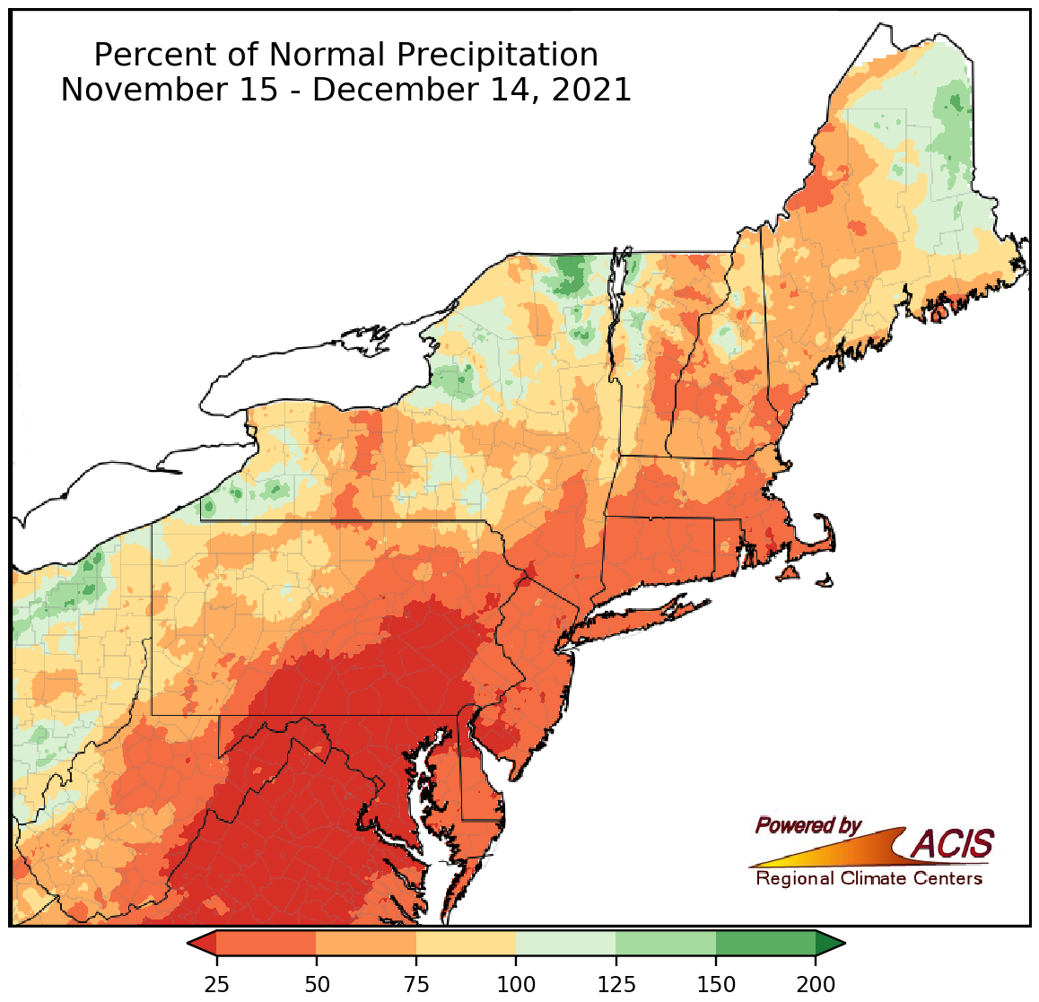
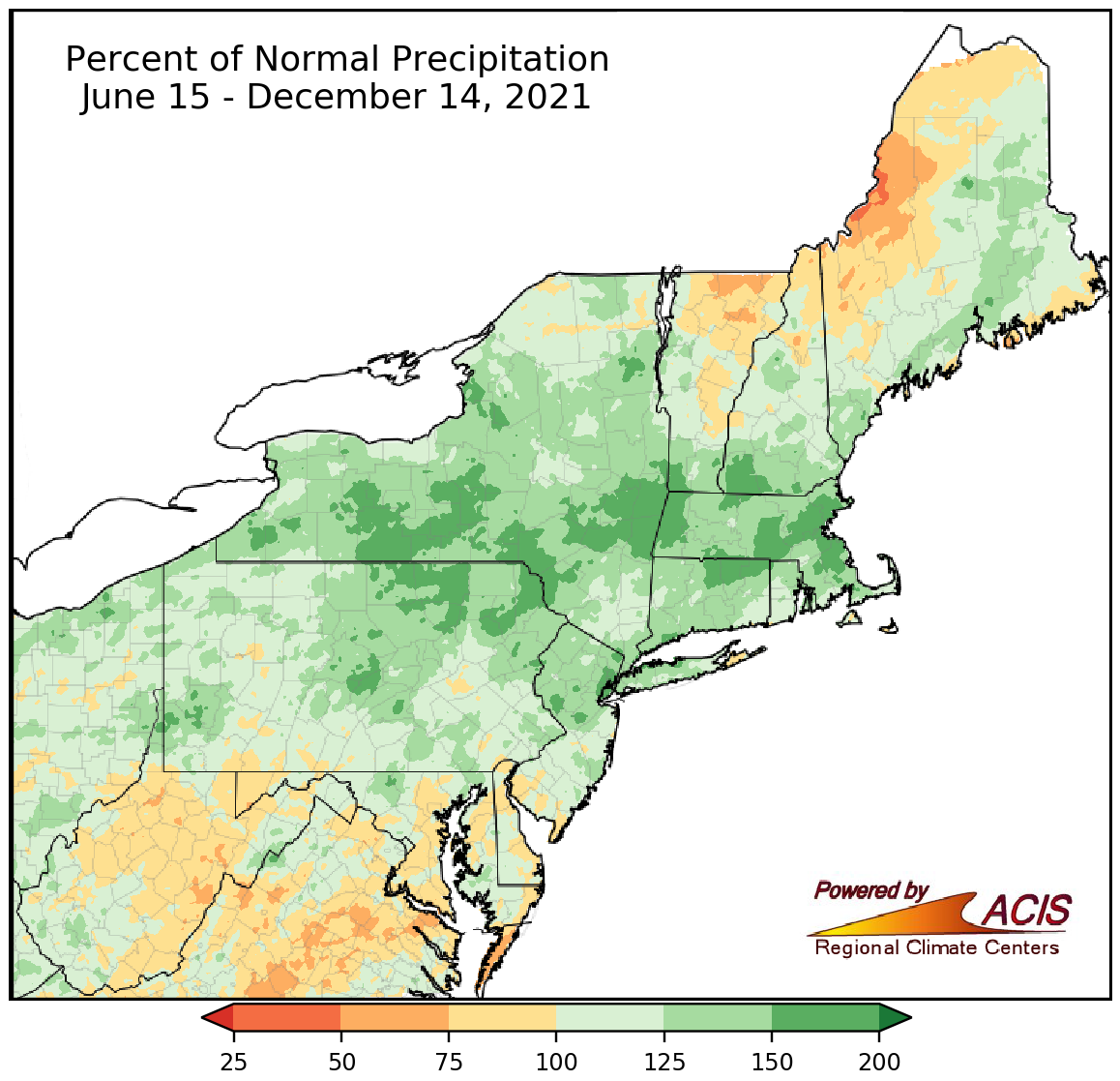
There was a nor'easter Oct. 25 - 26. I live in the Wissahickon Watershed with smaller creeks and main stem tributaries that feed the Schuylkill River where the drinking water comes from for where I live. Much of the city's infrastructure is older than a century (in fact there were 3 main breaks last week literally a few miles from where I live which thankfully only resulted in a water pressure drop at my house but complete outages closer to the breaks). I regularly monitor the USGS gauge for the Wissahickon (at the mouth) where it flows into the Schuylkill and during those excessive rains and flood events, have posted the charts. We are only in December. The temps of the ground and the nearby HUGE phenomena known as the Atlantic ocean, doesn't really chill down until months from now, even if there are occasional arctic intrusions earlier in the winter (and even those would need to be sustained to get the ground temps down to what they might be by late January into February). And I doubt if you have ever seen me post about a SECS event. I just monitor the various weather events that come through all year. I know what I posted may have appeared to be "too long" but the very first map was showing the drought conditions as of December 14 (and was posted on December 16th). There is no indication of drought in the LV based on that. The only area showing drought conditions was south-central PA - You can go to the sites I linked to and do various time periods. The Cornell site has this for the last 30 days (attached at the very bottom of the post next to the nor'easter sat image from Oct. 25 - 26) Not sure why you are not using the resources that are out there to show what has progressed over the past 6 months. I am a retired ACS-certified chemist and at least take advantage of the internet as an amazing resource! You had this happen as of early September so by now, the levels may be back closer to normal and getting dry - https://www.lehighvalleylive.com/news/2021/09/how-high-will-lehigh-valley-waterways-get-when-will-the-water-reach-its-peak.html But climatology in this state dictates certain times of the year when it does get dry and when it happens in the fall, the remnants from tropical cyclones (or non-tropical nor'easters) usually swoop in to save the day, although not 100% of the time.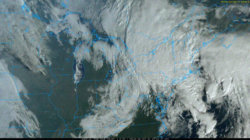

-
E PA/NJ/ DE Winter 2021-22 OBS Thread
Hurricane Agnes replied to JTA66's topic in Philadelphia Region
Going into fall,we were above normal here in metro Philly thanks to a rainy summer and then the remnants of Hurricanes like Ida. The latest PA drought monitor map is showing this as of this past Tuesday (taken from here and selecting the state) - https://droughtmonitor.unl.edu/Maps/MapArchive.aspx I I know that through today, I've had 0.80" and last month (Nov.) I had 0.89". But in Oct. I had 6.08", Sept. 8.57", Aug. 10.78", Jul. 3.93", Jun. 5.75", & May 4.06". So quite a bit of precip down here preceding the late fall period (some of which came from Ida remnants). YTD I have had 53.21" (including snow melt in the bucket), which is insane. So if you look at May - Nov. after which the spigot turned off, you see this trend - Cornell's NRCC drought monitor seems to align - https://www.nrcc.cornell.edu/regional/drought/drought.html It is also reflecting the dry up the past couple months so the question would be despite having the surface dryness now, whether the ground water is still somewhat charged from the summer.
-
E PA/NJ/ DE Winter 2021-22 OBS Thread
Hurricane Agnes replied to JTA66's topic in Philadelphia Region
The MJO (GFS/GEFS) to MJO... Most of the models are showing that hanging in Phase 7 but as soon as it moves to 8 it will be game on. At least Alaska's permafrost in parts of the state, is getting a refresh since it has been decimated by years of above-normal temps there. Currently 39 and overcast, with dp 37 (a far cry from yesterday's low 20s after the cold front passage) and have 0.13" in the bucket from the showers this morning.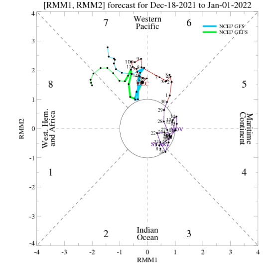
-
E PA/NJ/ DE Winter 2021-22 OBS Thread
Hurricane Agnes replied to JTA66's topic in Philadelphia Region
We had the below happen last Christmas. Pretty cool sat image, but the result (from my last year's sig) - 12/25/20=Trace (flurries) (you're trying though ) Climate change is real - as a note, when this year is done, it will be 27 years since the last time a below 0 temp was recorded at KPHL (1994). IMHO, the models are having a hard time with their algorithms deciphering/factoring in the changes in climatology.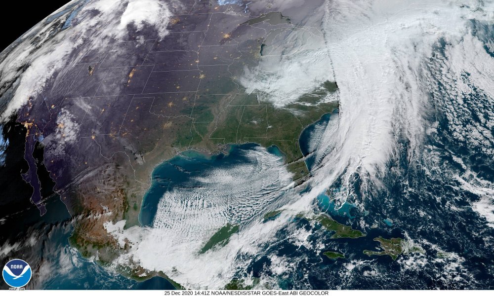
-
E PA/NJ/ DE Winter 2021-22 OBS Thread
Hurricane Agnes replied to JTA66's topic in Philadelphia Region
CPC/NCEP put out their most recent ENSO forecast last week - https://www.cpc.ncep.noaa.gov/products/analysis_monitoring/enso_advisory/ensodisc.shtml Their 3-month outlooks issued today - https://www.cpc.ncep.noaa.gov/products/predictions/90day/ (sorry ) We'll see if any of this verifies. -
E PA/NJ/ DE Winter 2021-22 OBS Thread
Hurricane Agnes replied to JTA66's topic in Philadelphia Region
There was a front-end thump and then it changed over to a sleet fest, finishing off as a freezing rain special that compacted the snow and left it with a frozen crust. In fact, I had saved a copy of my sigline with the events recorded from last year and I had this - In other news, there were 3 RERs issued today - Finally... I made it up to 61 as a high after a low of 47 and for a change, the sun was out pretty much all day (didn't cloud up like it did yesterday). The big difference today as well was the dp - no longer in the low 20s but up in the 50s. Currently 56 and clear with dp 48. -
E PA/NJ/ DE Winter 2021-22 OBS Thread
Hurricane Agnes replied to JTA66's topic in Philadelphia Region
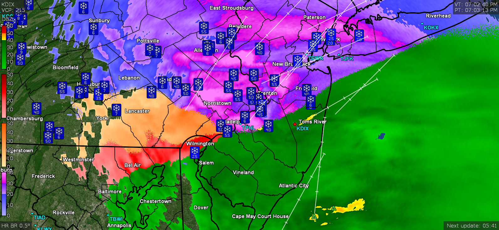
I have 37 snapshots of the doppler radar images from the storm (I usually do one about every 1/2 hour) and the LSRs reported by the program come and go on the maps over time. I have one from a couple hours later that is showing what may have been around the Bloomsburg area reporting a 12" as an example.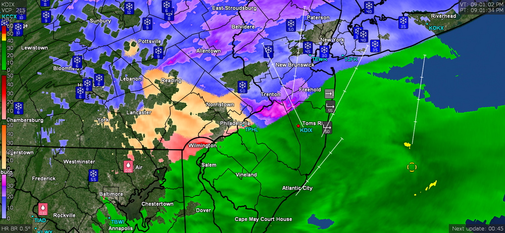
-
E PA/NJ/ DE Winter 2021-22 OBS Thread
Hurricane Agnes replied to JTA66's topic in Philadelphia Region

-
E PA/NJ/ DE Winter 2021-22 OBS Thread
Hurricane Agnes replied to JTA66's topic in Philadelphia Region
With departures like that, if some low did fly off the coast, it could become sub or extra-tropical, gaining a warm core, particularly if it gets cutoff from any front. -
E PA/NJ/ DE Winter 2021-22 OBS Thread
Hurricane Agnes replied to JTA66's topic in Philadelphia Region
Possibly because of this -