Hurricane Agnes
-
Posts
9,264 -
Joined
Content Type
Profiles
Blogs
Forums
American Weather
Media Demo
Store
Gallery
Everything posted by Hurricane Agnes
-
E PA/NJ/DE Spring 2022 OBS Thread
Hurricane Agnes replied to Hurricane Agnes's topic in Philadelphia Region
Had some loud rolling thunder and lightning (picked up by the detector too) and ended up with 0.14" of rain from the passage of the storm. Currently 50 with dp 45.
-
E PA/NJ/DE Spring 2022 OBS Thread
Hurricane Agnes replied to Hurricane Agnes's topic in Philadelphia Region
SPC updates (look similar to earlier but still holding with it) - SWDY1 - Also something for far N/W Chesco and Berks folks to keep an eye on - Currently 72 with dp 59. I did make it up to 75 here earlier before the skies started getting angry and battled the sun for supremacy. -
E PA/NJ/DE Spring 2022 OBS Thread
Hurricane Agnes replied to Hurricane Agnes's topic in Philadelphia Region
Worm moon and I know the robins have been having a feast! Am currently overcast and 56 with dp 53. Will see if it gets unstable today if the sun manages to appear before the cold front and possible convection later this afternoon. -
E PA/NJ/DE Spring 2022 OBS Thread
Hurricane Agnes replied to Hurricane Agnes's topic in Philadelphia Region
Low this morning ended up being 50 and the high 72. It's currently 64 with dp 56. I know there is a full moon out there obscured by some overcast. -
E PA/NJ/DE Spring 2022 OBS Thread
Hurricane Agnes replied to Hurricane Agnes's topic in Philadelphia Region
There is one (I think it is a star magnolia) that had budded up and is started to bloom not far from my house... Definitely early! There are also some cherries around the area that are blooming (although those seem to have sporadic blooms on and off all year including winter if there is a long enough warm spell). -
E PA/NJ/DE Spring 2022 OBS Thread
Hurricane Agnes replied to Hurricane Agnes's topic in Philadelphia Region
SPC SWDY1 - SPC SWDY2 more interesting (marginal risk with adjacent area west in slight) - -
E PA/NJ/DE Spring 2022 OBS Thread
Hurricane Agnes replied to Hurricane Agnes's topic in Philadelphia Region
The fog started lifting about an hour ago and the sun has been trying to break through but still have some low stratus. Temp is 54/dp 53 with bright overcast and clearing skies, along with occasional peaks of sun. -
Trying to save some $$$ although in the end it might not - even with a 1-year contract. (and that may be my first greenskeeper weenie tag I guess that was deserved )
-
E PA/NJ/DE Spring 2022 OBS Thread
Hurricane Agnes replied to Hurricane Agnes's topic in Philadelphia Region
That confirms that Kamu's snow mound has officially disintegrated and can no longer contribute to the area water table! This morning's obs comes complete with dense fog and a vis. < 1/10th of a mile here. Temp is 51 with dp the same. -
E PA/NJ/DE Spring 2022 OBS Thread
Hurricane Agnes replied to Hurricane Agnes's topic in Philadelphia Region
Wednesday's high was 69 and in contrast, today's high was a gloomy 55 (after a low of 48). With the on and off rain today, I so far have 0.22" in the bucket. Currently at my high of 55 with dp 54. -
Oh no! But then there is this -
-
E PA/NJ/DE Spring 2022 OBS Thread
Hurricane Agnes replied to Hurricane Agnes's topic in Philadelphia Region
Made it up to 67 today and it's currently down to 62 with dp 37 but did see that on the radar. I thought there might have been some chances, but only far north with a clipper that is scooting across the northern PA/southern NY border, where Thursday and the weekend were pretty much categorical. -
E PA/NJ/DE Spring 2022 OBS Thread
Hurricane Agnes replied to Hurricane Agnes's topic in Philadelphia Region
Mt. Holly posted some seasonal snowfall recaps last night - Obvious who cashed in big time! ^^Note the "non-zero" chance in April on average. -
E PA/NJ/DE Spring 2022 OBS Thread
Hurricane Agnes replied to Hurricane Agnes's topic in Philadelphia Region
Ended up hitting a high of 58 yesterday and had a low of 36 this morning. Still had some leftover patches of frozen stuff (sleet) in some of the protected areas. Currently sunny with some scattered cirrus and 46/dp 35. -
E PA/NJ/DE Spring 2022 OBS Thread
Hurricane Agnes replied to Hurricane Agnes's topic in Philadelphia Region
There are others of us who like "weather", no matter what type and certainly we do get severe and recently, an uptick of tornadoes, along with some kind of hurricane/TS remnant coming over the CWA. As an obs, had a low of 30 this morning and it's currently at 46 with dp 28. Since we had more sleet yesterday than other areas, there are still patches of frozen in the shaded grassy areas. -
E PA/NJ/DE Spring 2022 OBS Thread
Hurricane Agnes replied to Hurricane Agnes's topic in Philadelphia Region
Just getting virga. It did cloud over and get darkish. The air is so dry it might have a hard time wringing anything out though. Temp here is 32 with dp 15. -
Here's the updated PNS & LSRs from early this morning (KPHL ended up with 0.4") -
-
E PA/NJ/DE Spring 2022 OBS Thread
Hurricane Agnes replied to Hurricane Agnes's topic in Philadelphia Region
My low for yesterday ended up being just before midnight at 21 and this morning's low was 20. My lowest dp this morning was 8 but I have recovered to 14 and my current temp of 29 is so far my high for the day, with it mostly sunny. -
E PA/NJ/DE Spring 2022 OBS Thread
Hurricane Agnes replied to Hurricane Agnes's topic in Philadelphia Region
As a regular obs, I did get up to 47 today as a high and that was just before 6 am when the storm was just getting underway. Am currently at my low so far of 25, with dp now down to 14. My eventual low for the day is TBD 'cause I know the temps will continue to fall over night. -
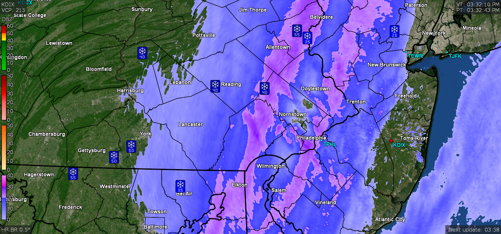
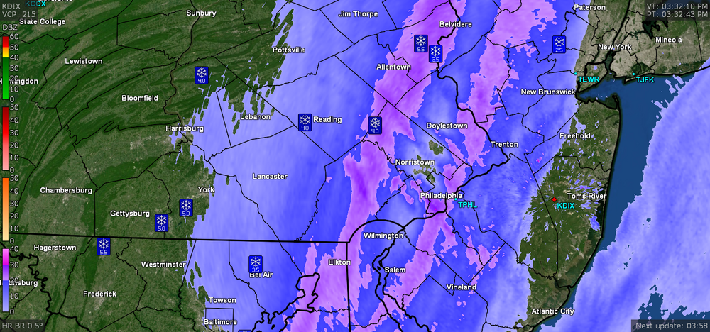
5 pm PNS and LSRs (KPHL reported "T" for 1 pm, which didn't make the last version - will have to see if they got anything from the last rounds if/when an update comes out) -
-
Was just getting ready to post that this is the first "clearing" I've had since yesterday (it didn't really clear or brighten much in between bands here). Sun is out and it's just over 30 minutes before sunset.
-
Glad you S. Jersey guys managed to cash in on something, and especially where you are not far from the ocean. I'm down to 25 here with dp continuing to drop and now at 17 so that arctic air is on the way there.
-
Just did another measurement for what fell from the last time (including the last 2 bands) and got 0.5" additional (compacted). Hard to measure with the winds blowing stuff on the cleared part of the board but managed to find spots to average that small amount. Temp is now down to 25 with dp 18 and there's just some leftover flurries along with some blowing/drifting snow. I'll go on and call the final event total 1.61" (to include the initial 0.1" sleet prior to the onset of the snow).
-
Steve Sosna (NBC10 on KYW) just mentioned that there was a 70-car pile up out in Harrisburg. Getting lots of blowing SN- to SN at the moment.
-
Snow has started up again and I am just getting the leading edge of it. There's a lot of blowing. Temp down to 26 with dp 20.