Hurricane Agnes
-
Posts
9,264 -
Joined
Content Type
Profiles
Blogs
Forums
American Weather
Media Demo
Store
Gallery
Everything posted by Hurricane Agnes
-
E PA/NJ/DE Spring 2022 OBS Thread
Hurricane Agnes replied to Hurricane Agnes's topic in Philadelphia Region
Seems like today's weather has escalated beyond what was progged. -
E PA/NJ/DE Spring 2022 OBS Thread
Hurricane Agnes replied to Hurricane Agnes's topic in Philadelphia Region
As an obs, temp is now partly cloudy and hazy 81 with dp a juicy 68... and you can feel it. -
E PA/NJ/DE Spring 2022 OBS Thread
Hurricane Agnes replied to Hurricane Agnes's topic in Philadelphia Region
Tornado Watch issued - WPC SWDY1 shifted the "Slight Risk" to the east over much of the CWA now - -
E PA/NJ/DE Spring 2022 OBS Thread
Hurricane Agnes replied to Hurricane Agnes's topic in Philadelphia Region
Heat Advisory has been issued for parts of the area (first of the season and calendar year) -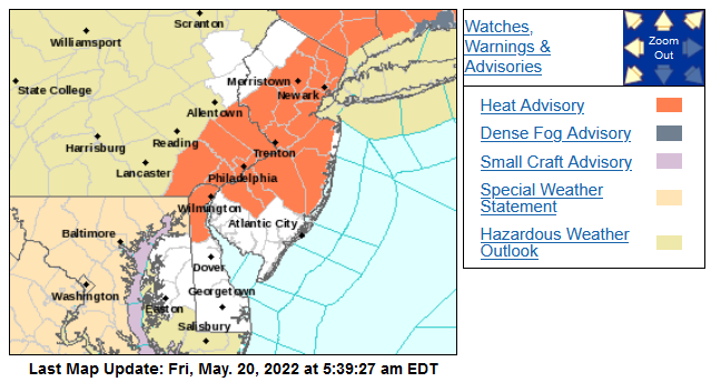
-
E PA/NJ/DE Spring 2022 OBS Thread
Hurricane Agnes replied to Hurricane Agnes's topic in Philadelphia Region
SPC DY1 and DY3 have the CWA in a general "Marginal Risk" for severe (with a "Slight Risk" for portions NW in DY1 outlook) - Currently at my low for the day (so far) at 58 with dp 58, and it's mostly cloudy at the moment a few minutes after sunrise. -
E PA/NJ/DE Spring 2022 OBS Thread
Hurricane Agnes replied to Hurricane Agnes's topic in Philadelphia Region
My latest stats were a final Tues. high of 80, a low of 52 and high of 73 yesterday, and a rainy low of 55 this morning that netted me 0.79". Sun didn't come out until this afternoon and the temp did eventually start to recover after being in 50s/60s all morning. Looks like my high is in the books at 76 today and it's currently sunny and 74 with a dp that did kick up today with that rain, and is sitting at 65. -
E PA/NJ/DE Spring 2022 OBS Thread
Hurricane Agnes replied to Hurricane Agnes's topic in Philadelphia Region
Had a low of 50 this morning but as progged, the temp quickly recovered and it's currently a breezy 77, with lots of "fair weather cumulus", and a dp of 48 after the drier air finally advected in. -
E PA/NJ/DE Spring 2022 OBS Thread
Hurricane Agnes replied to Hurricane Agnes's topic in Philadelphia Region
It's 20 minutes after sunset, so it's dark, and the robins (and other songbirds) are having a concert. Down to 62 with dp 62. -
E PA/NJ/DE Spring 2022 OBS Thread
Hurricane Agnes replied to Hurricane Agnes's topic in Philadelphia Region
Ended up woth 0.29" total rain for the day. The high made it to 78. Currently recovered to 63 with dp 63. -
E PA/NJ/DE Spring 2022 OBS Thread
Hurricane Agnes replied to Hurricane Agnes's topic in Philadelphia Region
Done. My Upper Darby sis texted a pic of a (smaller) downy woodpecker. I guess they are all out. Did hear one around here a few weeks ago but not recently. Am used to seeing the pilated ones up in a tree!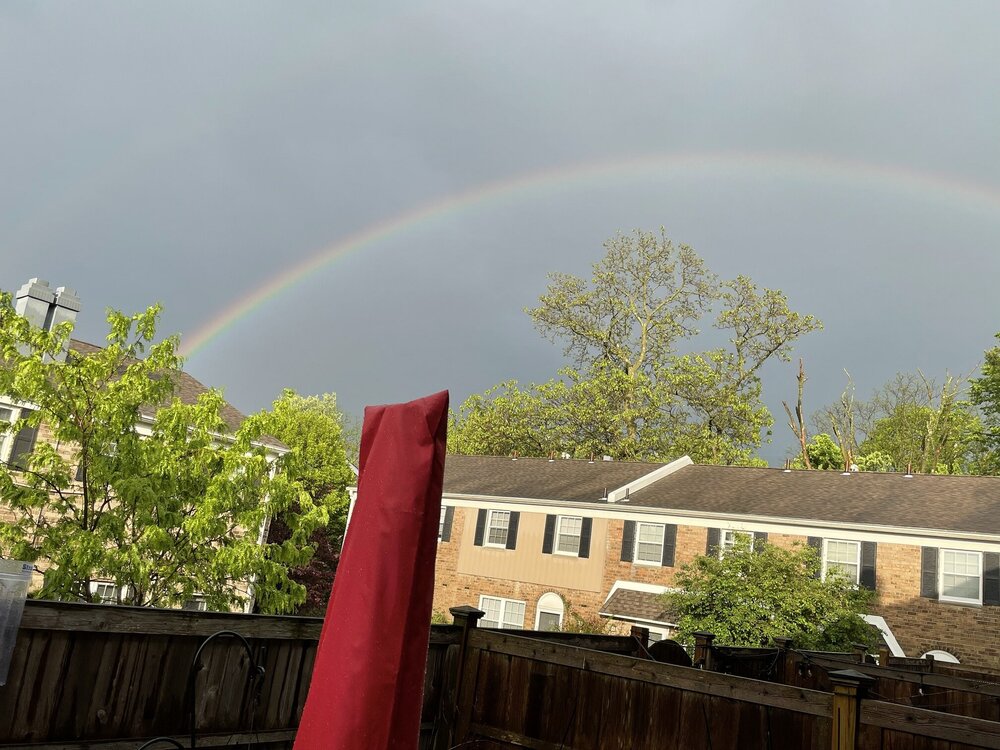
-
E PA/NJ/DE Spring 2022 OBS Thread
Hurricane Agnes replied to Hurricane Agnes's topic in Philadelphia Region
Still raining while sun is out and rainbow is rainbowing. Temp holding at 62 with dp 61. -
E PA/NJ/DE Spring 2022 OBS Thread
Hurricane Agnes replied to Hurricane Agnes's topic in Philadelphia Region
Sun out in the west, rain moving off to the east, and a nice rainbow has appeared as expected! -
E PA/NJ/DE Spring 2022 OBS Thread
Hurricane Agnes replied to Hurricane Agnes's topic in Philadelphia Region
Sky starting to brighten in the west as the back edge approaches. Have 0.28", at one point with as much as 0.75" - 1"/hr rates. -
E PA/NJ/DE Spring 2022 OBS Thread
Hurricane Agnes replied to Hurricane Agnes's topic in Philadelphia Region
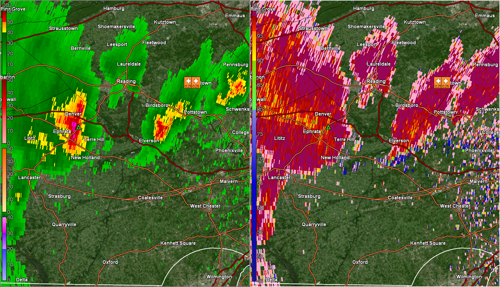
Only getting a little random thunder here but apparently the cloud-to-cloud has been active. Temp has dropped down to 62 with dp 60. Have 0.22" total in the bucket (including the 0.01" from earlier this morning).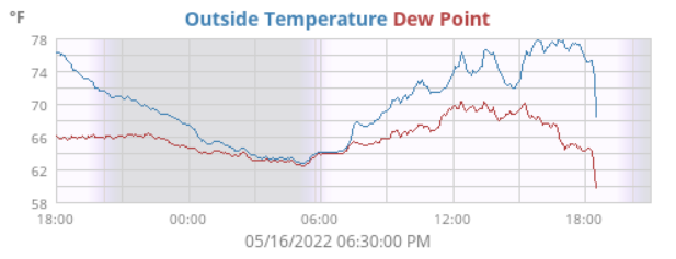
-
E PA/NJ/DE Spring 2022 OBS Thread
Hurricane Agnes replied to Hurricane Agnes's topic in Philadelphia Region
Just north of me is getting nailed. Temp down to 63 with dp 60.
-
E PA/NJ/DE Spring 2022 OBS Thread
Hurricane Agnes replied to Hurricane Agnes's topic in Philadelphia Region
Pea-sized hail flying here! -
E PA/NJ/DE Spring 2022 OBS Thread
Hurricane Agnes replied to Hurricane Agnes's topic in Philadelphia Region
On my doorstep and lightning detector is going nuts but am not hearing any thunder.
-
E PA/NJ/DE Spring 2022 OBS Thread
Hurricane Agnes replied to Hurricane Agnes's topic in Philadelphia Region
The cold front air is oozing in and it's getting gusty. Not quite at "gust front" strength although it approached like that. Currently 74 with dp 61 and dropping now. -
E PA/NJ/DE Spring 2022 OBS Thread
Hurricane Agnes replied to Hurricane Agnes's topic in Philadelphia Region
Got convection popping up on the detector.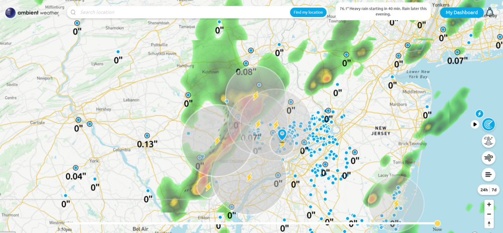
-
E PA/NJ/DE Spring 2022 OBS Thread
Hurricane Agnes replied to Hurricane Agnes's topic in Philadelphia Region
Got a solid line going with the sun. It's clouding up here but the sun still wants to push through. Temp is 76 with dp 64.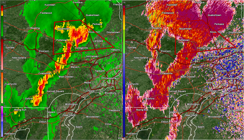
-
E PA/NJ/DE Spring 2022 OBS Thread
Hurricane Agnes replied to Hurricane Agnes's topic in Philadelphia Region
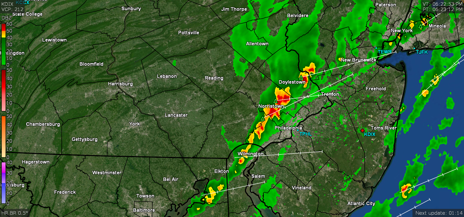
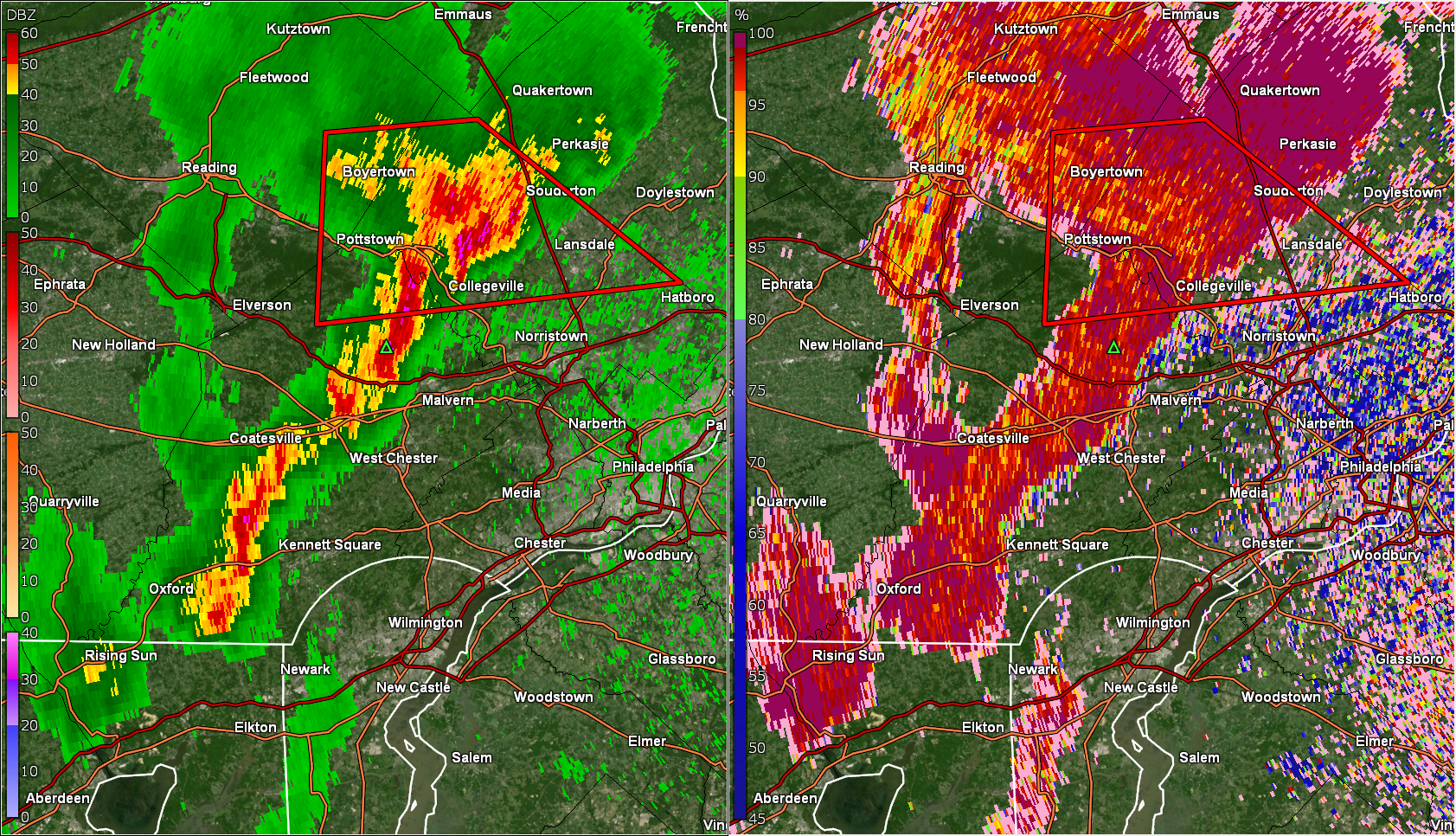
Mt. Holly has a STS up - -
E PA/NJ/DE Spring 2022 OBS Thread
Hurricane Agnes replied to Hurricane Agnes's topic in Philadelphia Region
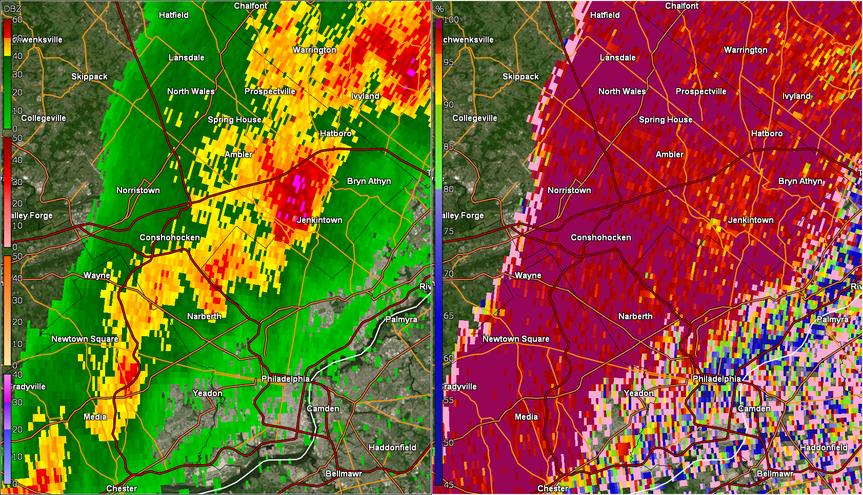
That is the CC (correlation coefficient). -
E PA/NJ/DE Spring 2022 OBS Thread
Hurricane Agnes replied to Hurricane Agnes's topic in Philadelphia Region

-
E PA/NJ/DE Spring 2022 OBS Thread
Hurricane Agnes replied to Hurricane Agnes's topic in Philadelphia Region
This was Mt. Holly's updated Watch - And an updated view of S/W Watches to include Sterling sites and Mt. Holly extensions - -
E PA/NJ/DE Spring 2022 OBS Thread
Hurricane Agnes replied to Hurricane Agnes's topic in Philadelphia Region
The front is sortof creeping along but it is cooler behind it. One of my sisters just texted and asked "What happened to all the rain and thunderstorms and tornadoes?????" She had pushed herself doing some outdoor weeding and other stuff in prep for the rain. Temps were in the 50s back behind the front (from a couple hours ago).