TheClimateChanger
-
Posts
4,407 -
Joined
-
Last visited
Content Type
Profiles
Blogs
Forums
American Weather
Media Demo
Store
Gallery
Everything posted by TheClimateChanger
-
Pittsburgh, Pa Summer 2024 Thread.
TheClimateChanger replied to meatwad's topic in Upstate New York/Pennsylvania
Only about half that in my backyard, but over 3/4” since yesterday afternoon. It’s been a nice rain coming in several brief spurts so no significant flooding issues. -
Occasional Thoughts on Climate Change
TheClimateChanger replied to donsutherland1's topic in Climate Change
For lack of a better place to put this, holy cow. h/t @donsutherland1 -
Central Pa. Summer 2024
TheClimateChanger replied to mahantango#1's topic in Upstate New York/Pennsylvania
I already showed there was one more 90F+ at MDT at this point in the year than there was in 2020. And then people came in rebutting that objective fact by saying there were fewer this July than in July 2020 and that I wasn't considering the backloading of prior summers where there was lots of 90s in August and even September. None of which is relevant to the fact that there was more 90s this year so far, and only a select few years with more. -
Central Pa. Summer 2024
TheClimateChanger replied to mahantango#1's topic in Upstate New York/Pennsylvania
I'm looking at met summer to date. But comparing this to 2020 certainly doesn't mean it's not been the hottest summer to date. In fact, it has been at MDT. 2020 was the prior hottest summer to date. So it's really funny saying it's only "4 short years ago" - what difference does it make how long ago when it was literally the prior hottest summer? Lol.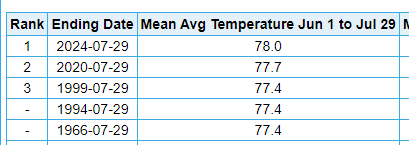
-
Central Pa. Summer 2024
TheClimateChanger replied to mahantango#1's topic in Upstate New York/Pennsylvania
Actually no, because I can't predict the future. It would make little sense to compare this year's numbers to a full calendar year. One thing I find interesting is if you compare 1943 & 1944 to this year at the same location in which they were observed (CXY), this year actually jumps out to a slight lead.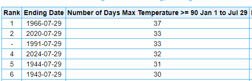
-
Central Pa. Summer 2024
TheClimateChanger replied to mahantango#1's topic in Upstate New York/Pennsylvania
This one is even more impressive. 50s scattered all over the place, even DC. At 18z in mid August. -
Central Pa. Summer 2024
TheClimateChanger replied to mahantango#1's topic in Upstate New York/Pennsylvania
Anyways, for the cold weather enthusiasts, you will love to see this. Very skeptical of low 50s at 18z in early August in northern Pennsylvania, but we shall see. -
Central Pa. Summer 2024
TheClimateChanger replied to mahantango#1's topic in Upstate New York/Pennsylvania
For most people in this subforum, it's probably the hottest summer to date for their lifetimes (certainly top 2/3) and one of only a select few years in terms of 90s. I'd say that's pretty impressive. -
Central Pa. Summer 2024
TheClimateChanger replied to mahantango#1's topic in Upstate New York/Pennsylvania
Very impressive figures. This summer seems to be performing very well in terms of heat here in the Commonwealth of Pennsylvania on a variety of metrics. -
Central Pa. Summer 2024
TheClimateChanger replied to mahantango#1's topic in Upstate New York/Pennsylvania
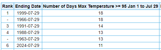
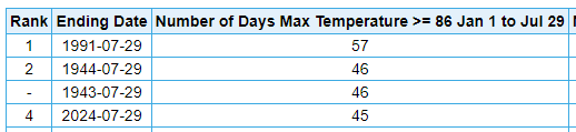
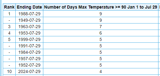
I haven't seen much discussion of this. But this summer has done incredibly well on 90+ days at Harrisburg. I know some have complained that recent warm summers haven't been super impressive on that end. Good chance to tack on number 26 today. At this point in the year, only 5 years have had more 90+ readings. This is the most since 1999. Same story with 95+ days: For the metric lovers, days at or above 30C/86F: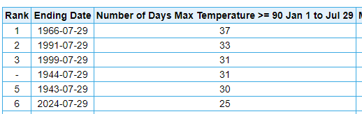
-
I would agree. There seems to be little objective evidence that this has "not been a hot summer" in the New York City metro area. It looks like it's top 3-5 to date at all of the local climate sites. I do note there's been a push on this forum to redefine what a hot summer is to strictly look at the number of 90+ days and/or to consider only one's subjective feelings rather than objective facts. But even with the 90+ metric, 2024 is doing pretty well in most places. At Central Park, only 18 years (dating to 1869) have had more days at or above 90F. And this is despite the encroaching jungle / shading of the ASOS. At Newark, only 10 years have had more days at or above 90F [3 of those 10 with just 1 more]. It's actually not normal for there to be constant 90s in the New York City area. If you think it is, you are misremembering. Now, it is true that JFK has only had 2 such days, which is actually one of the lower tallies there. But that's not representative of much of the region.
-
July 2024 Observations and Discussion
TheClimateChanger replied to HoarfrostHubb's topic in New England
Also, people, it's actually not normal to have constant 90s in the summer - even in hot summers, in much of the northeast. Looking at ORH airport data only, I can find only 9 years with more 90s at this point in the year (out of 77 years). So only about 1 in 9 summers historically would be expected to have more 90s at this point, and none since 1999. BTV, dating back to the 1800s, only 9 years have had more 90s at this point. By contrast, 22 years had 0 90s at this point & 40 years had only 1 or fewer. CON, 8th most dating back to 1869. Only 2 years since 1978 have had more. It's crazy to me how people have to redefine what a hot summer is to pretend it's not a hot summer.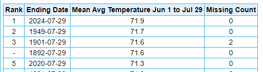
-
July 2024 Observations and Discussion
TheClimateChanger replied to HoarfrostHubb's topic in New England
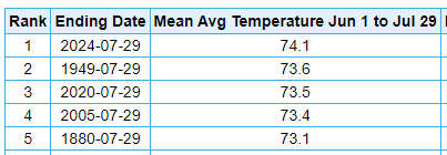
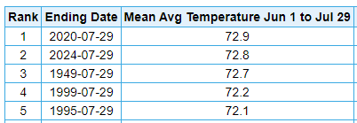
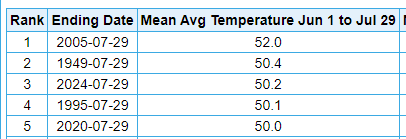
2F above normal with the artificially inflated 1991-2010 norms is a HOT month. They already raised the norms like 1-2F from what they were in the 1990s. So this same month would have been considered blazing hot in the 1990s. 3-4F is a big deal in July. Let's play a game. Is it the hottest summer to date in SNE? At ORH, yes. At BOS, no. Tied for sixth place. CON, that would be a no. 4th place officially, but these are some suspiciously high readings from the early 1870s. BDL, yes. Just outside the greater SNE region. ALB, yes. Probably more NNE, but BTV. No, in 2nd place, 0.1F behind the blazing hot summer of 2020. Mount Washington, New Hampshire (MWN). No, 3rd place.
-
Central Pa. Summer 2024
TheClimateChanger replied to mahantango#1's topic in Upstate New York/Pennsylvania
That was also the 5th 90+ day of the season at Bradford. Since records began in 1957, only one calendar year had more 90+ days. In 1988, a total of 8 days reached at least 90F at the Bradford Regional Airport. -
Central Pa. Summer 2024
TheClimateChanger replied to mahantango#1's topic in Upstate New York/Pennsylvania
Record high of 90F at Bradford today, easily breaking the record of 87F set in 1988. A couple other locations approached record highs as well. DuBois reached 89F, 3F shy of the record set in 1988. Altoona topped out at 92F, 2F below the record set in 2002. -
Central Pa. Summer 2024
TheClimateChanger replied to mahantango#1's topic in Upstate New York/Pennsylvania
2011-2024 is only 14 years, so that means nearly half of them were among the top 14 warmest of 130 years. Widening out ever so slightly, and 8 of the top 20 have occurred in the past 15 years.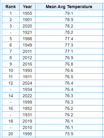
-
Phoenix Experiences its Hottest June on Record
TheClimateChanger replied to donsutherland1's topic in Climate Change
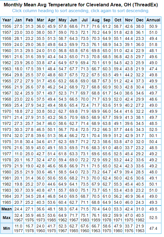
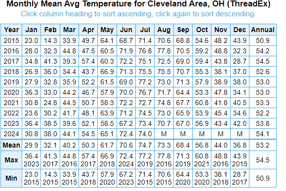
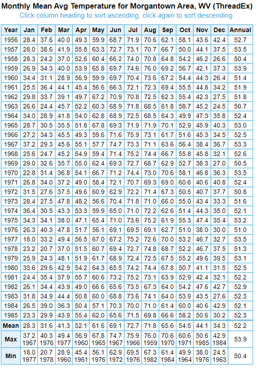
It's always surprising to me how much colder Chicago is than Cleveland in the wintertime. Being upwind versus downwind of the Great Lakes makes a huge difference. 1956-1985 at CLE (Dfb, bordering on Dfa): Last 10 years below. Very solidly Dfa. The mean of the coldest month is 1.6F warmer than the mean of the coldest month at Morgantown, West Virginia, from 1956-1985. Looks to be on the same path as PIT. Likely Cfa by mid-century using 0C definition.
-
Phoenix Experiences its Hottest June on Record
TheClimateChanger replied to donsutherland1's topic in Climate Change
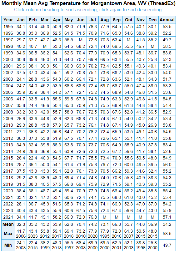
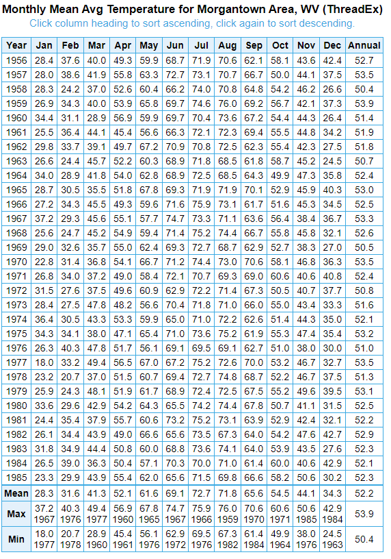
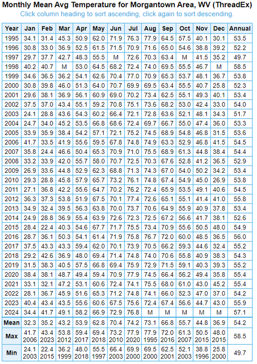
Looks like the border between warm summer and hot summer subtypes is actually 22C, which is 71.6F. Looking at historical data, the "normal" July mean at PIT (Pittsburgh International) was 71.9F in the 1960s and in the 1980s climatology. The 1960s climatology was based, in part, on a smaller POR and comparative data to infill since records didn't begin until 1952. I believe the 1970s climatology had the mean at 72.3F. Technically hot summer continental (Dfa), albeit bordering on warm summer continental (Dfb). Today is solidly hot summer continental (Dfb). The more significant change coming soon - at least as far as the Koppen classification is concerned - will be the transition to humid subtropical climate (Cfa). Based on the data presented below, I would surmise that this transition will occur within the next 20-25 years (extrapolating from trends over recent decades). Looking at data for the last 10 years, we can see the mean of the coldest month is 29.9F over that period. Above the traditional -3C criteria, but still below the 0C criteria typically used for North American climates. 60 miles to the south, we can see Morgantown, WV has averaged 32.3F in its coldest month over the past 30 years, making it fully Cfa by all metrics. By contrast, the 30-year mean from 1956 to 1985 was 28.3F, so that's a 4F rise in just 40 years. Heck, even February was colder than recent Januarys back then. Interestingly, it that period, even Morgantown was only about 0.5C above the border for warm summer continental (Dfb).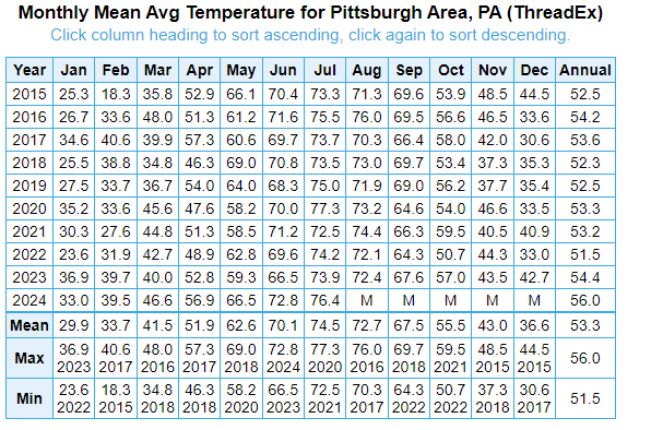
-
Central Pa. Summer 2024
TheClimateChanger replied to mahantango#1's topic in Upstate New York/Pennsylvania
I think this is something lost on a lot of people. Some like to point to a few scattered years in the historical records and say "look, it's been hotter." But they ignore the fact, that also scattered in the mix were many summers that were far colder than any recent summer. Like 2003 & 2004 at KPIT, the highest temperature was 88F in that 2-year stretch. What are the odds of that recurring any time soon? -
Central Pa. Summer 2024
TheClimateChanger replied to mahantango#1's topic in Upstate New York/Pennsylvania
Good luck on that one. I suspect 2003 & 2004 were the last mild summers on record. By mild, I mean in a historical sense. Obviously, there will always be cooler than normal summers [like last year], but due to the rising means, those wind up nowhere near historically cold summers.
-
Central Pa. Summer 2024
TheClimateChanger replied to mahantango#1's topic in Upstate New York/Pennsylvania
I mean 6 of the top 14 [and 5 of the Top 10, for that matter] in the last 14 years with records dating to the 1800s is still pretty dominant. -
It's a good thing we have objective data to analyze this instead of one's feelings. Probably when you were a kid, you were out in the heat and now as an adult have to work in an air conditioned setting. Even sorted by mean maximum temperature, the top 4 hottest summers at DCA have all occurred since 2010. Obviously, 2024 is not over but it certainly appears destined to place in the Top 5, which would mean the Top 5 have occurred in a 15-year span. Further, there's a good reason to believe the values from 1986 to 1995 at DCA [and all other first order sites] were inflated relative to readings before and after that era [which included several summers with high maximum temperatures - 1987, 1988, 1991, 1993, 1994 and 1995]. Even so, each of the summers from 2010-2012 and 2016 surpassed those levels [and 2024 seems poised to do so as well]. Sources: climo_rpt_96_2.pdf (colostate.edu) - Study of 79 first-order climate sites between 1994 & 1995 found an average annual max temperature bias of +1.16F, and an average annual low temperature bias of +0.95F from the HO-83 relative to the ASOS installation. Comparison of ASOS and HO-83 temperatures at Lincoln, Nebraska from November 1991 through October 1992 (noaa.gov) - 12-month study from Lincoln, Nebraska study 1991-92. ASOS was from 1.4 to 2.6F cooler for maximum temperatures every month, and from 0.7 to 2.5F cooler for minimum temperatures. An Investigation of Temperature Discontinuities Introduced by the Installation of the HO-83 Thermometer in: Journal of Climate Volume 8 Issue 5 (1995) (ametsoc.org) - Another study, somewhat smaller estimate of 0.6C bias - actually suggests less bias in summer, but not sure that is correct. Ironically, I learned about this decades ago from climate change deniers. At that time, they were blaming climate change (in part) on this faulty sensor. Obviously, a ridiculous argument since U.S. first order airport sites make up a very small fraction of the USHCN sites, and almost zero percent of the global climate stations [the majority of which is water, after all]. But I correctly guessed it would turn to pointing to these same years as being evidence it wasn't warming as much as they said. The HO-83 Hygro- thermometer « Climate Audit - cites some more sources, particularly about Tuscon and how the NWS could not confirm a global warming signal in the deadly Chicago heat wave of 1995 because the readings were likely inflated by instrument bias
-
Pittsburgh, Pa Summer 2024 Thread.
TheClimateChanger replied to meatwad's topic in Upstate New York/Pennsylvania
Surprisingly made it up to 91F at Butler Regional (BTP) today [a typically cooler part of the metro area], where there's been significantly more sun and the lower dewpoints held off. Only 85 at KPIT, with some scattered showers starting to move into the region. -
Pittsburgh, Pa Summer 2024 Thread.
TheClimateChanger replied to meatwad's topic in Upstate New York/Pennsylvania
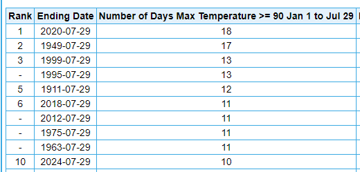
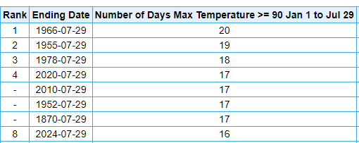
92/51, as of 4 pm. One thing you had pointed out, all of the 90+ readings this year have been 91F or better. Historically, a disproportionate number of 90+ days have topped out at exactly 90F. It makes a pretty substantial difference if you rank years by days with a high temperature greater than 90F [i.e., 91F or higher]. By that metric, only 9 years in the threaded record had more days strictly above 90F. And only 3 years since 1894 (1988, 20; 1966, 18; and 1952, 17). 2012, 1933 and 1901 also had 15 such days by July 28. -
Pittsburgh, Pa Summer 2024 Thread.
TheClimateChanger replied to meatwad's topic in Upstate New York/Pennsylvania
Additionally, today was the 67th day at or above 80F. That matches 1934 for the second most 80+ readings by this point in the calendar year. Only 1991 had more, with 74 such days.