jwilson
-
Posts
1,294 -
Joined
-
Last visited
Content Type
Profiles
Blogs
Forums
American Weather
Media Demo
Store
Gallery
Everything posted by jwilson
-
Western Pa / Pittsburgh area Winter Discussion ❄️☃️
jwilson replied to north pgh's topic in Upstate New York/Pennsylvania
I think the NAM is still too far out of its comfort range to be instructive. There's the rare occasion where it picks up on something, but usually you want to avoid the NAM until its under 48-60 hours. As you can witness on the NAM, the high pressure is bouncing all around, but I think it should be fairly locked in because of the overhead blocking (-NAO) and a ~50/50 low. The system that will eventually evolve into Wednesday's threat is just now hitting the west coast. The GFS at 12Z remains the most progressive of all the models. That solution creates such strong frontogenesis that you'll have winners under an INTENSE deform band with divergence elsewhere. The 12Z even screws much of Central PA that looked "safe" under other, previous solutions. Basically, you get a very narrow range of top snow depth instead of a widespread event. I'm not inclined to take the GFS at 100% right now. That said, the entire system is clearly vulnerable to disruptions, because it is early in the winter and we don't have a colder airmass established. The warm Atlantic waters are another wild card. It's also not near a true Miller A, which is what we really need to see for Pittsburgh to capitalize on these setups. Widespread overrunning snows. It's more like 75% Miller B and 25% Miller A. Those coastal transfers are tricky to time down. Too late and the mid-Atlantic misses out entirely. -
Western Pa / Pittsburgh area Winter Discussion ❄️☃️
jwilson replied to north pgh's topic in Upstate New York/Pennsylvania
Case in point: the EPS has a 60-80% chance of Pittsburgh metro seeing more than 3" of snow this week and a 30-40% chance of 6" or more with a mean through Friday of 5". Game isn't over. -
Western Pa / Pittsburgh area Winter Discussion ❄️☃️
jwilson replied to north pgh's topic in Upstate New York/Pennsylvania
There's still quite a few ensemble members of the GFS and Euro that swing a good bit of snow back across the entire state. Ridging out west, the digging s/w, or the high pressure can all influence the direction the low(s) move. The Canadian came right back to the same solution it had a couple days ago, however. It will be interesting to see if it remains consistent. It was curious to see the Euro come around to that same solution today while the GFS hints a bit more at it, but keeps the flow too progressive. Maybe the GFS is the new Dr. No. The GFS keeps it active through the period. The Euro looks like it transitions to a real +EPO signal around Christmas (not good). It will be curious to see what ends up winning out if the AO keeps tanking while we have less pacific ridging. Perhaps we get an "artificial" -EPO due to a shifting or splicing of the PV. -
The GFS also has Euro support (or is it vice versa?). Should be an interesting week ahead. The 0Z Canadian also had a system in this same timeframe, but the surface low tracked right over Philly. We'll see if the 12Z suite alters any details.
-
Western Pa / Pittsburgh area Winter Discussion ❄️☃️
jwilson replied to north pgh's topic in Upstate New York/Pennsylvania
Well, it's been quiet here. Rightfully so, I guess, because there isn't much going on in the interim. Long-term, the signals keep flipping back and forth, but a -NAO appears relatively likely. Perhaps in 48 hours we're back to a NINA look, I don't know, but it has been quite a while since we've seen any kind of true, even transient, -NAO block during the winter months. The last -NAO for December I can find is 2009 (we remember what happened then). From a "winter" perspective, 2010 was it, with negative values quite literally the entire year and into 2011. Columns after the year run from January to December. That was the end of our blocking winters. Since then, the only real blocking has come during the summer or fall months, and all winters have averaged well above positive. "A decade under the influence." This might all be for naught, but I figured since there isn't much going on, I'd try my hand at some analysis for the upcoming period, which looks like it could be surprisingly active. First is the Canadian for next Tuesday. After this weekend, which pretty much all models are visualizing a cutter, we head into next week that really looks more interesting. We see it is holding a rather large, singular piece of energy back into the southwest. This is usually a good sign for a big NE snowstorm. There's ridging along the west coast and, although the flow looks transient ahead, I think this is more a symptom of this s/w digging. This is the GFS at the same time: The GFS is much less organized. It is stringing out some of the same energy all over, while also holding a bigger piece back off the coast. It comes crashing in a few frames later: That's the remaining piece of energy coming into Seattle. Still, it keeps it separate and moves some smaller bits out ahead into the great lakes area. Very northern-stream dominant. At the same time, the Canadian keeps bowling: Now it's a closed-off ULL. Pretty much concentrating all the energy right there near the four corners. The Canadian then digs this all southward into the Gulf, dragging and phasing the northern stream energies into one significant trough. On the GFS, however: The American model keeps the streams separate. It has these two distinctive blocs, but it also has a piece of NS energy holding up in Canada. Basically, instead of how the Canadian crashes all this energy together into a cohesive system, the GFS times them apart and prevents things from ever morphing. It's a strung-out mess. See the final GFS look here: As I just said, the GFS is strung-out and tries to dig some of the energy south, but the northern stream is still keeping other bits of energy off the same conveyer belt. Eventually it does form a Miller A (of sorts) on its own, but because of the separation here, the cold air is also pulled away and the trailing system (seen here digging into TX) has no cold air to work with. What we get is a rain storm. Meanwhile, the Canadian: Puts a nice closed-off bowling ball right over the Jersey shore. Even the Canadian setup is kind of off-kilter - resulting in a double-barrel low of sorts - but it brings a lot of snow into the Mid-Atlantic. It isn't a great look for Pittsburgh because of the confluence, but if shifted just a little to the northwest, Pittsburgh would be in the game for the bigger totals. Meanwhile, this verbatim would jackpot areas around D.C., Philly, and New York, almost 11 years to the day after a very similar system did the same. The remaining question is - which of these models has support? As of the 12Z runs today, it looks like every model is kind of doing its own thing. There isn't a ton of agreement on the evolution of these pieces of energy. To be expected at this range and with this many moving pieces. Clearly it will take some time to lock in the results, but at least for now, we do have a period to watch upcoming. Whether anything results is pure speculation. Given how this winter was expected to develop as a STRONG NINA (now backing off that idea considerably, to the point where the Nina may be collapsing imminently), I think this is about as positive as we could have hoped. -
I can't necessarily speak for the Philly area, but I know in the western part of the state we have had two Top-10 coldest Novembers in the last three years ('18 - 8th, and '19 - 10th). For the actual winter months, I'll have to go out further than Top-10. The most recent notable record is February 2015 (second coldest ever), followed by January 2003 (11th) and December 2010 (12th) . February of '07 and '14, December of '00 and '05, and January months of '03, '04, and '09 are all contemporary records. However, all of those months are way down the lists in the teens or even twenties. March is barely represented. 2014 is it on the "top" list, and it is way down there (19th). In the Top-18 for cold March, the most recent is March of 1984. Seems March hasn't been all that cold in a long time. Daily and yearly records are harder to find. 1994 is the most recent cold day. Seems the 80s were kinda cold, overall. If we consider certain elements to be cyclical, maybe things will shift back the other direction eventually. Or maybe climate change will prevent that and things are forever different and unpredictable. That analysis goes above my pay grade. TL;DR: One Top-10 in the last 20+ years: February of 2015 (for actual winter, anyway).
-
Western Pa / Pittsburgh area Winter Discussion ❄️☃️
jwilson replied to north pgh's topic in Upstate New York/Pennsylvania
The CMC quickly abandoned this look, waiting until the storm was off Maine's coast to wrap it up. The Euro shows a prototypical Miller A path from the Gulf, through Alabama/Georgia, and then setting it up off the Delmarva. The GFS has a very similar setup, a bit more convoluted, but there's no "snow side" or cold sector. It's all rain and shears off south of our area. Lack of cold air definitely is one concern. Seems this one might be an inland NE special. Really, I think 2010 was the last of this kind of storm. Pittsburgh is still long overdue for an 8"+ event. -
Western Pa / Pittsburgh area Winter Discussion ❄️☃️
jwilson replied to north pgh's topic in Upstate New York/Pennsylvania
I have friends in Mercer county that got well over a foot (perhaps upwards of 16-18"). That's crazy. Goes without saying but in areas with lake effect enhancement and/or elevation, this event pushed towards overperformance. -
Western Pa / Pittsburgh area Winter Discussion ❄️☃️
jwilson replied to north pgh's topic in Upstate New York/Pennsylvania
I measured a little over 3" a couple hours ago. The snow was extremely fine down here most of the day, but this last push may get us upwards of 5" or so. No complaints about this event on December 1st. Let's hope it is a sign of things to come the rest of the winter and not the exception. Heck, if we were to hit 5" officially, this storm alone would be more snow than we've gotten in 4 of the last 6 Decembers. -
Western Pa / Pittsburgh area Winter Discussion ❄️☃️
jwilson replied to north pgh's topic in Upstate New York/Pennsylvania
Looks like it should be snowing here, but it's just virga. Column looks mostly saturated so I guess the precip is still too light. -
Western Pa / Pittsburgh area Winter Discussion ❄️☃️
jwilson replied to north pgh's topic in Upstate New York/Pennsylvania
RGEM nails the AGH snow-hole, or inverted bullseye. Lock it in, boys! Also, cut the amounts by 25-50%.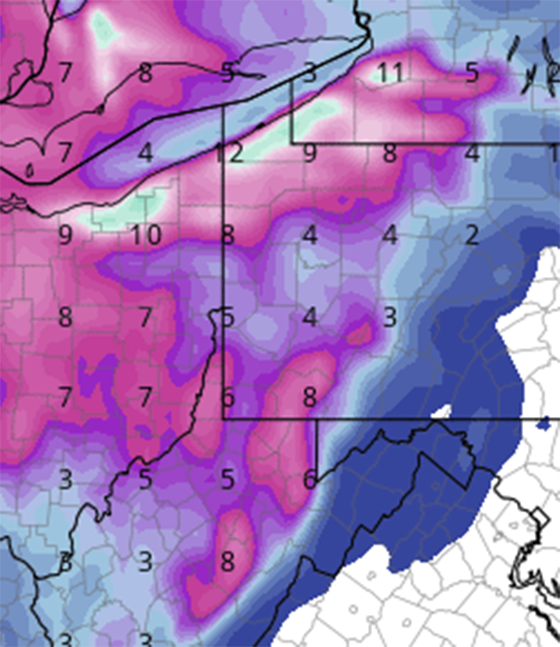
-
Western Pa / Pittsburgh area Winter Discussion ❄️☃️
jwilson replied to north pgh's topic in Upstate New York/Pennsylvania
Other than '17-'18 (13.3"), we've had a brutal run for December snow over the last six years. If this season unfolds as expected, any snow early is worthwhile, even needed. This won't be the blockbuster we'd all hope for, but perhaps we can muster a minor event out of it for the first accumulation. -
Western Pa / Pittsburgh area Winter Discussion ❄️☃️
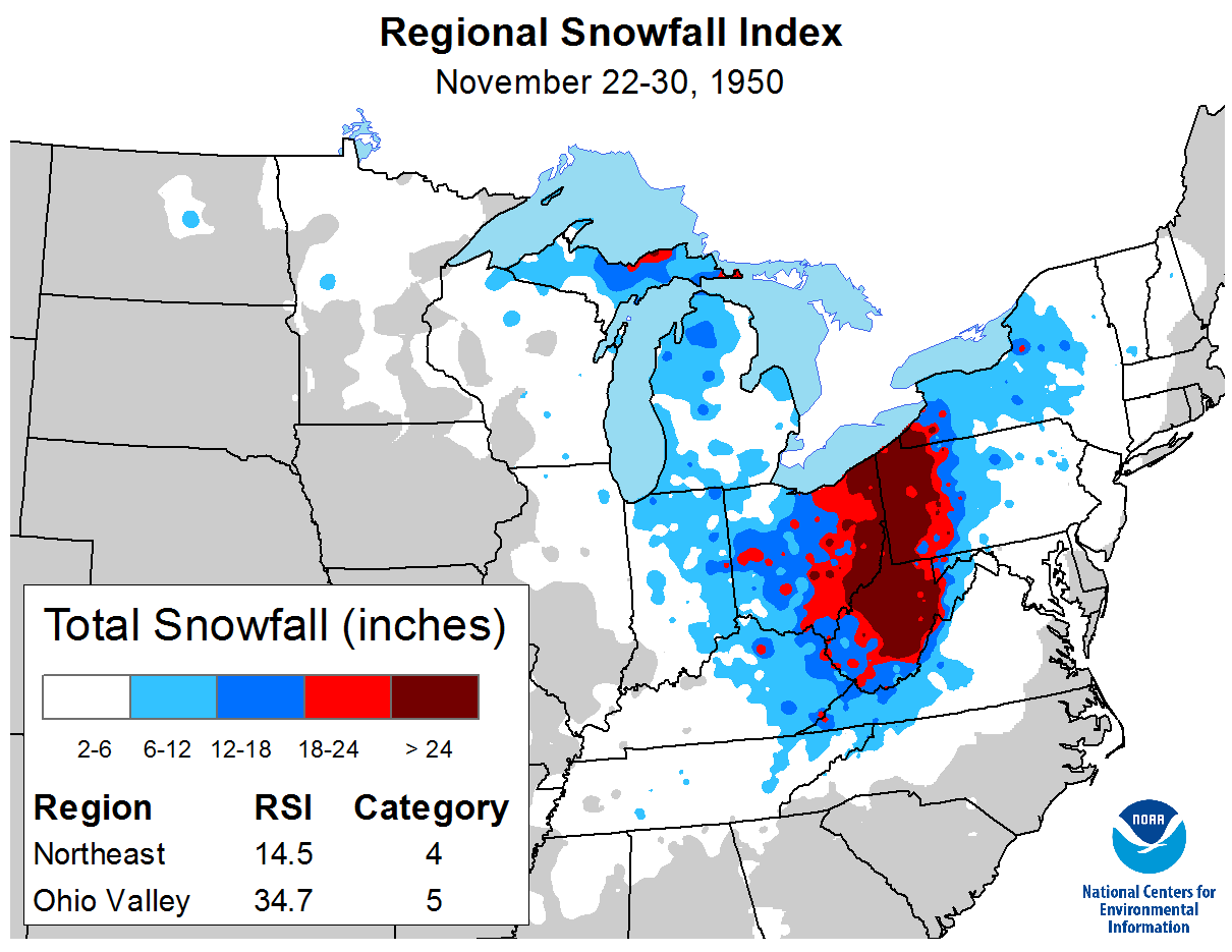
jwilson replied to north pgh's topic in Upstate New York/Pennsylvania
That snowfall map above looks quite familiar...
-
Website Builder Suggestions and Help? thanks!
jwilson replied to ChescoWx's topic in Philadelphia Region
Dreamweaver is pretty comprehensive, and it helps a ton if you know how to code HTML/PHP/CSS (among others). That's the only true web developing program I've ever used. If you don't have much experience coding, you can consider using something like Squarespace which gives you templates and does most of the backend work for you. Most of those sites end up looking a tad "samey" which might be a turn-off, but if you aren't overly concerned with looks, you might not care. I'm guessing for your needs, you'll be more concerned about functionality and utility versus aesthetics. Wordpress is another option. If you're data-heavy, building a MySQL/SQL database will be a more intensive task but may be worth it in the long-run. That said, it really depends what you need. If you're not relying on queries or interactivity much then it's possibly overkill. I used to do freelance web developing back in the day. It has been a few years since I've truly built a website from scratch, but if you needed some assistance with basic things I could probably help. Likewise if there are any graphics you need.- 1 reply
-
- 1
-

-
Pittsburgh PA Spring and Summer 2020 Thread
jwilson replied to meatwad's topic in Upstate New York/Pennsylvania
This winter looks like it could be the strongest La Nina since the winter of 2010-11.. which, if we look back, Pittsburgh received 56.7" of snow that year, decently above the most recent 30-year average of 42" or so. Now that's a simplistic look at the Nina (you can dive deeper into the specific east/west/central orientation). I don't have the time right now to look much deeper. I will, however, quickly compare other strong La Nina winters (anything below -1.0 value) to see how Pittsburgh has done historically in snowfall terms, starting with the most recent: 2011-12 // Peak Nina value of -1.1 - Snowfall: 36.9" 2010-11 // Peak Nina value of -1.7 - Snowfall: 56.7" 2007-08 // Peak Nina value of -1.6 - Snowfall: 41.2" 1999-00 // Peak Nina value of -1.7 - Snowfall: 27.1" 1998-99 // Peak Nina value of -1.6 - Snowfall: 39.2" 1988-89 // Peak Nina value of -1.8 - Snowfall: 21.7" 1984-85 // Peak Nina value of -1.1 - Snowfall: 36.4" 1975-76 // Peak Nina value of -1.7 - Snowfall: 35.6" 1973-74 // Peak Nina value of -2.0 - Snowfall: 16.6" 1970-71 // Peak Nina value of -1.4 - Snowfall: 59.9" Average snowfall over these 10 winters: 37.1" The mean Nina prediction right now favors one below -1.5. I could keep going back further but figure records from that era are relatively meaningless given overall climate changes. From this sample of 10 years, however, we see that the majority of these winters are below average in snowfall terms (7 out of 10). One year is basically right on average, while two winters were above normal. Once again, I admit this is a very basic analysis and does not include looking at other teleconnections or signals that could have driven the winter beyond the Nina/Nino state. Still, even at the basic level, this isn't a promising look if you're a snowfall lover. Assuming we manage a strong Nina, chances greatly favor a below-average snowfall season. This could be considered bad news coming off one of the WORST snowfall seasons last year (22.4", lowest since 1990-91). Ultimately, it isn't set in stone, however. There are chances some other atmospheric condition could override or overpower the Nina and drive the dominant weather pattern. The forecast for above-average temps all winter obviously coincides with a prediction for less snow than "normal," but again, it doesn't guarantee anything so long as there are actual cold spells from time-to-time. On an additional note, I think I consider 2010-11 an outlier given it was the follow-up to the tremendous winter of 2009-10, which will remain unmatched for who knows how long. Those winters were aided heavily by a record-breaking -AO, making the ENSO state much less important. -
Pittsburgh PA Spring and Summer 2020 Thread
jwilson replied to meatwad's topic in Upstate New York/Pennsylvania
So are we going to pay for this in October with 90s, or are we going to have an actual autumn this year? -
Pittsburgh PA Spring and Summer 2020 Thread
jwilson replied to meatwad's topic in Upstate New York/Pennsylvania
I'm a storm chaser at heart, so mostly I'm interested in storm development for something to follow. Yesterday's early morning derecho that swept across the state acted like a broom for our area and essentially pushed all the instability south and east of us. The resulting outflow setup convection across extreme southern PA into WV. Locally, we haven't had a real thunderstorm since April 8th. I have to think two months during the spring without an event is pretty unusual for this area, although June and July are the peak months on average. The cooler spring is the main culprit, of course. Considering it will maintain 80s through October nowadays I guess we have to be okay with it. We'll likely make up for it later. Yep. It's bad enough missing out during the winter months, but now we keep missing during thunderstorm season, too? In the end I'm sure it's just a blip. Things will turn around at some point. Theoretically they should, anyway. -
Pittsburgh PA Spring and Summer 2020 Thread
jwilson replied to meatwad's topic in Upstate New York/Pennsylvania
Another "slight" risk of severe today and it looks like, once again, Pittsburgh metro and points north will miss out. Depends on your perspective, of course, but it seems like the metro area has been having some bad luck lately on the stormy weather. Everything seems to be missing south or farther north. -
Pittsburgh PA Spring and Summer 2020 Thread
jwilson replied to meatwad's topic in Upstate New York/Pennsylvania
At this time of year, if anything over a trace would be historic, a 9" snowfall would be biblical, and I'd consider Armageddon right around the corner. -
Pittsburgh PA Spring and Summer 2020 Thread
jwilson replied to meatwad's topic in Upstate New York/Pennsylvania
We've had a trace of snow in May twice since 2000 ('01-'02 & '15-'16).. let's go for a third. -
Pittsburgh PA Spring and Summer 2020 Thread
jwilson replied to meatwad's topic in Upstate New York/Pennsylvania
If it wasn't for today, we would have had a higher max temp in January (71) this year than in April (70 was previous max). Oof. -
Pittsburgh PA Spring and Summer 2020 Thread
jwilson replied to meatwad's topic in Upstate New York/Pennsylvania
Well that was an intense line, definitely one of the most dynamic cells I've witnessed since living here. Tornado warning popped on the TV, but it wasn't really for us. Hope you're all good up in New Kensington. Twitter report said there was a tornado near Markle. I was watching power flashes in the distance from my viewpoint. Actually a lot of other strange lighting colors during the storm, as well. -
Pittsburgh PA Spring and Summer 2020 Thread
jwilson replied to meatwad's topic in Upstate New York/Pennsylvania
-
Pittsburgh PA Spring and Summer 2020 Thread
jwilson replied to meatwad's topic in Upstate New York/Pennsylvania
We got a very brief and minor bout of hail yesterday with that "supercell," but it seemed the actual hail core went south of us, closer to Canonsburg. Our hail was minuscule in comparison (pea size at the most). -
Pittsburgh/Western PA Banter & Complaint Thread
jwilson replied to blackngoldrules's topic in Upstate New York/Pennsylvania
For 2009, even I got screwed a tad on that one being in the Philly suburbs. Philly measured 23" and I got 12" - that entire winter was full of tight gradient snow storms.