

jwilson
-
Posts
1,294 -
Joined
-
Last visited
Content Type
Profiles
Blogs
Forums
American Weather
Media Demo
Store
Gallery
Everything posted by jwilson
-
Western Pa / Pittsburgh area Winter Discussion ❄️☃️
jwilson replied to north pgh's topic in Upstate New York/Pennsylvania
Entering the first - and hopefully last - dry slot of the day. Rates dropped off significantly. That first round put down a light coating on most surfaces. -
Western Pa / Pittsburgh area Winter Discussion ❄️☃️
jwilson replied to north pgh's topic in Upstate New York/Pennsylvania
Definitely snowing here now in the South Hills. A consistent rate but still quite light. -
Western Pa / Pittsburgh area Winter Discussion ❄️☃️
jwilson replied to north pgh's topic in Upstate New York/Pennsylvania
I'm checking the cams here: http://wv511.org/#MapPlace:-80.146723587035:39.608696977762:-79.817133743284:39.711115431707 It looks like it is actually starting to snow now. -
Western Pa / Pittsburgh area Winter Discussion ❄️☃️
jwilson replied to north pgh's topic in Upstate New York/Pennsylvania
As for nowcasting time, I do see some 30 DBZ returns to our south already, which would be pretty far ahead of schedule. I'm trying to see if it's actually snowing in Morgantown, but it doesn't look like it yet. I'm guessing we're still in virga territory. Edit - ah I do see a few flakes in downtown. Perhaps it has started. -
Western Pa / Pittsburgh area Winter Discussion ❄️☃️
jwilson replied to north pgh's topic in Upstate New York/Pennsylvania
I can understand that. It is unfortunate. Big storms are too rare for Pittsburgh. However, for some hope today, the HREFs still have a 30% chance of more than a foot, and the ensemble mean remains between 10-12" across most of Allegheny. I think it might be crazy, but at least there's a tiny bit of guidance that still looks like the 12Z NAM from yesterday. -
Western Pa / Pittsburgh area Winter Discussion ❄️☃️
jwilson replied to north pgh's topic in Upstate New York/Pennsylvania
Yeah kind of a strange result from the NWS to up my totals overnight. That seems to go against the grain of the model trends with a less moisture-laden system. It was 4-8" when I went to bed and 6-9" now. I like the 4-8" call and think that was adequate. I think somewhere between 4-6" is the most likely result for the majority of our sub, exclusions to our eastern-most residents that could get more. Still a slight chance we hit higher end totals if we get the banding right, I'm just less confident in that now. Also strange to see the GFS so far apart from most every other model still. While it's a relative disappoint to what could have been, I think everyone here would have signed up for two 3"+ storms before Christmas, especially knowing it was a Nina. -
Western Pa / Pittsburgh area Winter Discussion ❄️☃️
jwilson replied to north pgh's topic in Upstate New York/Pennsylvania
I wanted to add this bit of analysis, even if it's a tad stale by now. One of the more under-rated aspects as to why the 12Z NAM and 0Z NAM gave us such different results could be because of a northern shortwave pressing down less on the overall picture. First we see the 12Z NAM run: In this view, we can see that northern stream piece of energy fluxing a "mini trough" down over Minnesota. This, in turn, lowers the heights and contours of the overall Eastern CONUS trough and raises heights along the East Coast. What that means: it forces the energy and the associated low with the coastal to ride a more westerly track and tuck farther into the Delmarva area (even into the Chesapeake). It heads more north or NNE instead of just NE or even east. However, the 0Z changes that piece of energy: The 0Z NAM makes this piece of energy far less relevant. In that sense, the s/w has less overall effect on the trough and allows for a more progressive or flatter look to the heights along the East Coast. The associated low can then escape quicker or, at least, take less of an "amplified" track that would otherwise force it into Delaware or southern PA. The main energy now sweeps across New Jersey and south of D.C. instead of right over the urban corridor. That's enough of a difference to take us out of the main game, so to speak. I would imagine the models have a better handle on all these energies now closer to game-time. If that's true then it's an unfortunate result, but not totally unforeseeable. -
Western Pa / Pittsburgh area Winter Discussion ❄️☃️
jwilson replied to north pgh's topic in Upstate New York/Pennsylvania
Well, this is the last minute trend we were worried about. Seems we're now running into a consensus and that takes the truly more impressive totals off the table for PIT. Eight inches is not a bad event, but now we're getting to the point where that looks like our absolute max instead of closer to the lower or middle end of averages. It's a fast reversal of the trend that favored us for a couple days, but it also means that trend could continue into tomorrow. Hopefully not. Analysis - 0Z 3K NAM is unequivocally worse for PIT. With the 18Z NAM, we had snow from 18Z Wednesday (1 PM) until 8Z Thursday (3 AM). 1-1.25" QPF, which actually cut back from 12Z (which was mostly 1.25" in the entire county with a small blip of 1.5") and 6Z (similar). At 0Z, half the county gets only .5 while the eastern edge gets .75. Most of Allegheny gets 6" with no high spots. 12Z and 18Z hit a foot in spots (with the former hitting a foot over the entire county). That's off the table for now. Timing is generally the same; onset at 17-18Z and ending at 8Z Thursday (very light). The biggest difference is this run keeps PIT outside of all the major deform bands and under generally lesser snowfall rates. You can see the compacting of the precip shield with this 0Z NAM run. The western side of the system looks much drier than before. It snows for 12 hours or more and we get 6" of snow for it. You can do the math and see that the rates are mostly abysmal. The best snow growth - according to the 3K - happens during the beginning of the storm. We maximize lift only one hour after the onset (2nd hour of snow) which is followed by one more hour of good lift, but then after that, it's largely garbage snow growth. To my novice eyes, it looks like there are much stronger westerly winds above the surface leading to dry air intrusion, thus effecting ratios. There's also considerably less omega and as I understand it, cold air advection (which is sinking, not rising air). These decreases are additionally reflected in the SREF plumes, which dropped substantially. The average on 15Z approached a foot; it is now down to 8.5" or so. Instead of more than a dozen members over 12", only two now. The majority (18) are still clustered between eight and twelve inches, however. Only eight members are under the average. That's obviously a flinch but not a total loss. These totals are usually overdone regardless, IIRC. All the other mesoscale models dropped our totals, as well, except the RGEM which kept them steady. The WRF-HMM is the most progressive, by far, and gives us only 2-3" in Allegheny. The ARW2 went from an absurd 18-20" down to a "measly" 6-10" (which is likely far more accurate, but it still is a considerable difference). The last thing I'd say is that, once again, this is going to come down to mesoscale features of the system. I don't like our odds of hitting 12" anymore, perhaps less than a 2% chance, but our floor hasn't really decreased much, if at all. 4-8" is a safe bet with no shutouts on the table, at least. Hopefully this trend doesn't continue. It does, however, look like the precip shield will ultimately be less impressive and more susceptible to dry air inundation on the western edge. -
Western Pa / Pittsburgh area Winter Discussion ❄️☃️
jwilson replied to north pgh's topic in Upstate New York/Pennsylvania
Yeah, the 18Z GFS wasn't great, pretty much a "worst case" for us (only drops 3-6" in Allegheny, which would be a bust of sorts). However, keep in mind this storm will be heavily dependent on mesoscale features like banding, and that is not in the GFS' wheelhouse. The GFS has one major band and puts Pittsburgh under nothing but subsidence. That's still a possible scenario, no doubt, but I think you have to resolve those features using other higher-resolution models plus forecasting. On a 1 to 10 scale of bust potential, this storm is probably a 7 or 8. But because of that, it could also overperform, so there's good and bad. Unfortunately, there's also some unknown that comes with it. I still think our absolute max potential is 14" with a low probability (say 10%) while 4" is the floor. I'm good with anything over 3" in mid December, and we've already done it once! -
Western Pa / Pittsburgh area Winter Discussion ❄️☃️
jwilson replied to north pgh's topic in Upstate New York/Pennsylvania
Every model gives PIT at least six inches. Mesoscales included. Some are better, some are around that mark. Averaging them, we get about 11" (across six different models and assuming 10:1 ratios through the entirety). Perhaps ironically, the SREF plume average is also right around 11", which is up slightly from the previous run. There are less lower members and two that are now higher (over 17"). That's the good news. The bad to be aware of but isn't confirmed yet: I hope we don't see a big SE correction last minute, but it's not impossible. -
Western Pa / Pittsburgh area Winter Discussion ❄️☃️
jwilson replied to north pgh's topic in Upstate New York/Pennsylvania
Probably mid-afternoon (1-3 PM). There's some flux, but the evening commute will almost certainly be poor. -
Western Pa / Pittsburgh area Winter Discussion ❄️☃️
jwilson replied to north pgh's topic in Upstate New York/Pennsylvania
At this point, 4-6" seems like the floor with the initial onslaught of snow. The question becomes where the CCB sets up and what kind of rates it can produce. NWS recently updated to puff the totals a little. I think that's a fine forecast for now. We have through 12Z tomorrow, give or take, to see what the mesos say. -
Western Pa / Pittsburgh area Winter Discussion ❄️☃️
jwilson replied to north pgh's topic in Upstate New York/Pennsylvania
Yeah, the GFS isn't as good as the mesos for PIT, but it bumped up considerably from 6Z to 12Z. A nasty gradient in the county from West to East.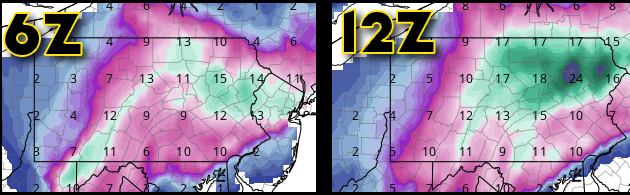
-
Western Pa / Pittsburgh area Winter Discussion ❄️☃️
jwilson replied to north pgh's topic in Upstate New York/Pennsylvania
Wow, the 12Z NAM doesn't back off. That's incredible. The last time I remember the NAM scoring a coup was 2016, when it was north of all of globals, then with 24-36 hours left, all the globals came north to the NAM. I'm not buying just yet, but I've got my wallet out. Even with the Ferrier correction on the 3K, Pittsburgh metro gets a foot. It shifts the jackpot from Harrisburg to Lock Haven, which isn't insignificant (about 70 miles). If PIT gets under the CCB as it forms along the axis, it could happen, but that's relying on a very specific feature. -
Western Pa / Pittsburgh area Winter Discussion ❄️☃️
jwilson replied to north pgh's topic in Upstate New York/Pennsylvania
Basically the "dry conveyor belt" as the low pressure center begins to mature and occlude, forming that traditional "comma" shape. You can look at a comma and see how there's a natural space between the head and the tail. -
Western Pa / Pittsburgh area Winter Discussion ❄️☃️
jwilson replied to north pgh's topic in Upstate New York/Pennsylvania
So I was checking out the 3K NAM at 6Z which is a pretty decent hit (visualized) for PIT. We wet bulb around 1 PM tomorrow and have decent lift in the DGZ for the first few hours. Then we wax and wane, transitioning to a loss of consistent lift there. Until ~05Z (which would be around midnight) when we hit maximum lift in the DGZ due to the CCB. So many acronyms, I'm sorry. Unfortunately, it doesn't last long, and the best rates appear to diminish quickly as the heaviest band moves hurriedly to the east. If you're a snow watcher, that means the best rates will be in the dark, though the onset of precip doesn't look bad. The heaviest stuff barely avoids PIT metro for a while and looks to bury Westmoreland/Armstrong/Indiana counties, for example. I suppose that's not unusual. There's also a time between 7 and 9 PM where PIT gets very close to sleeting due to southeasterlies above the surface, brought on by (I believe) extreme frontogenesis. This also kills the lift in the DGZ for a little so there might be a minor lull in snowfall rates. This is extreme over-analysis of one run, but it gives a bit more detail about one possibility as to what could occur. Glossary - DGZ - Dendritic Growth Zone (upper atmosphere where snowflake growth is achieved most efficiently; see graphic below) CCB - Cold Conveyor Belt (an aspect of "occlusion" that transports cool, moist air westward around the center of low pressure; "comma head") -
The GFS was the last one to hang onto SE PA, and with the 6Z it took that away to some degree. Seems Mt. Holly needs to adjust their forecasts badly. I still can't tell if Scranton or Harrisburg will jackpot. Maybe both?
-
Western Pa / Pittsburgh area Winter Discussion ❄️☃️
jwilson replied to north pgh's topic in Upstate New York/Pennsylvania
The 0Z NAM isn't really any further NW, and in fact keeps colder thermal profiles for places like Philly and NJ, but it creates a massive CCB that dumps snow over the entire middle of the state (which attempts to reach out here). Kind of a crazy look. I know the clown maps will be overdone, but I'll laugh at them anyway like a mad scientist. -
Haha, you're not alone so don't worry about it. I might chase this one, but I'm still hesitant with the eventual northward jog. I agree with others and think this is going to end up a heavy sleet storm, at least for a while, from my normal locale in Southeast Montco. This is the kind of storm I remember from childhood that was also a bit of a loser for my area and much better up in places like the Lehigh Valley. Maybe the confluence can win out, but I'm not super confident in that with the relatively marginal cold. 2009 this is not.
-
Does the GFS, et al. still have trouble parsing snowfall from sleet? In other words, do those clown maps take into account sleet accumulation, as well, or are they measuring strictly what it perceives as snow per local soundings? I would imagine the mesoscale models do a better job at handling that differentiation, but that's a hard guess on my part.
-
Western Pa / Pittsburgh area Winter Discussion ❄️☃️
jwilson replied to north pgh's topic in Upstate New York/Pennsylvania
I've seen the NAM overamped before, but this is taking it to another level. It is on its own so really it can't be trusted, especially with the GFS and Euro being as relatively consistent as they've been. I do think the GFS will jog a bit more northwest before the event. Enough to save a fringe job? I don't know. 3-6" might be a fine "catch all" and if it overperforms, so be it. -
Western Pa / Pittsburgh area Winter Discussion ❄️☃️
jwilson replied to north pgh's topic in Upstate New York/Pennsylvania
It's amazing to see how far apart the NAM and another meso model like the RGEM are in placement. I don't know that I've seen such a difference when considering the time frame. This is more instinct than anything, but I'm getting the sense this is modeled as an overperformer for certain eastern metro/urban areas. It is screaming sleet storm to me with a warm-water driven SE flow. Relatively marginal cold. This isn't like the cold air that preceded 2009 (low to mid 20s). Is the GFS too progressive? Now I don't know that things will shift as far west as the NAM likes, but as usual, a blend might be the best way to go. The Euro is kind of in the middle. It isn't great for our area, though. -
Isn't there a secondary in the Ohio Valley? The trend recently has been to kill it off quite quickly, but at least it used to be there. Also, this might of interest to you guys, but I had no idea there was an 18Z CMC? Is it of equivalent value? You can see the shift in the heaviest axis of precip from 12Z to 18Z, with the latter looking a lot more like the GFS. If this off, I guess we'd find out at 0Z. 12Z 18Z
-
Based on relatively recent history, that area of subsidence seems fairly consistent. I remember watching those bands just to the west of my house (Hatboro) and being dismayed at the near-miss. That was during the last few of these Miller-B hybrid systems. Maybe it's just coincidence. I don't know if there's a climatological or geographical reason for it to happen that way outside of elevation and/or distance from the ocean.
-
Western Pa / Pittsburgh area Winter Discussion ❄️☃️
jwilson replied to north pgh's topic in Upstate New York/Pennsylvania
Appreciate the thoughts. I haven't lived here all my life, but in the time that I have, I can't remember Pittsburgh ever scoring significantly in a Miller B setup. For "significant" I consider 8" or more. I could certainly be wrong or misremembering, anyone care to fill in the gaps? Seems Pittsburgh metro, at least, does best in either big overrunning, Miller A events, or convoluted setups that aren't either traditional coastal "nor'easter" types. '93 was obviously unique and likely never equaled, and I don't know 1950 or 1890 well enough to define them.


