

CentralNJSnowman
-
Posts
103 -
Joined
-
Last visited
Content Type
Profiles
Blogs
Forums
American Weather
Media Demo
Store
Gallery
Everything posted by CentralNJSnowman
-
Is it just me, or are both posts above in response to the request for a Kuchera of the AI Euro, actually 10:1 maps, not Kuchera?
-
Start thinking about it, but no need to pull the trigger yet unless there's limited availability on Saturday flights
-
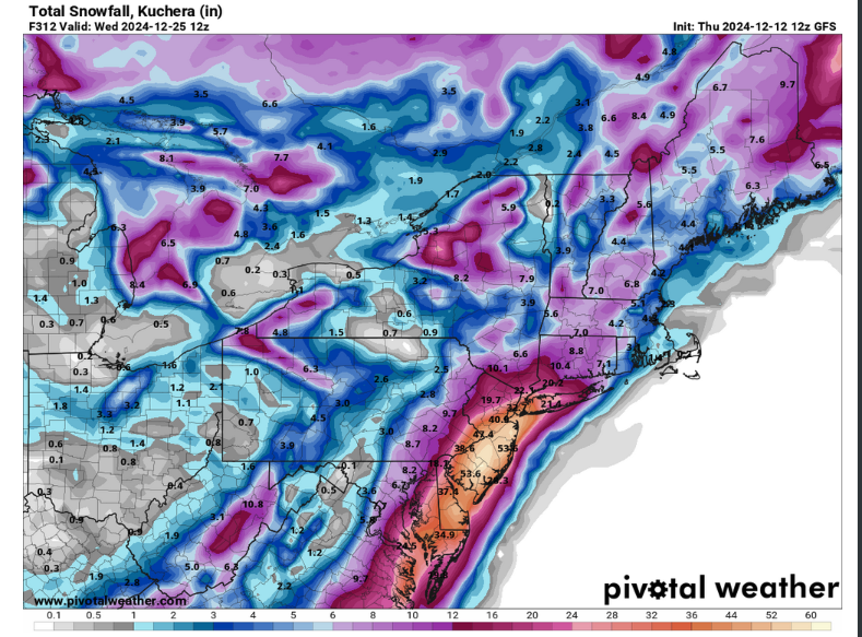
At least since last week when the GFS had a run that buried OH, PA, NJ, WV, NY, CT, RI and MA in 3-6 feet of snow.
-
Storm potential January 17th-18th
CentralNJSnowman replied to WeatherGeek2025's topic in New York City Metro
At least an inch of new snow over the past two hours in Monroe township nj -
Storm potential January 17th-18th
CentralNJSnowman replied to WeatherGeek2025's topic in New York City Metro
As Sacrus said above, it’s snow. At least in Monroe. I’d describe it as more like moderate snow than heavy snow though. -
That's pretty wild. Looks like a total of only 6 out of 34 happened earlier than January 15.
-
Ah I see. The ranges were right for the 'Expected' amounts, which seem to be equal to the top of the 'experimental, probabilistic amount ranges'. Confusing way to present things, but at least kind of makes sense.
-
The numbers showing on the maps have no correlation with the numbers on the map key. For example, Syosset and Stony Brook say 3-8" on the maps, but their color says 8-12" on the key. Similar discrepancies throughout the map.
-
Good trends this morning for those of us in Central NJ. No matter how long I'm at this, I STILL underestimate how much things can change at the (relatively) last minute...I was feeling pretty discouraged last night (I'm in southern Middlesex, near the Monmouth border). At this point, I wouldn't be surprised if I get an inch of sleety slop and also wouldn't be surprised if I get six inches of snow.
-
Not sure comparing Lake Placid in the 80s and 90s to NYC area in 2020s is a good gauge of climate change. Pretty sure most winters are still quite cold and snowy in Lake Placid...even during Christmas week.
-
"This is the hardest I've seen it snow in years" - typically posted about every 2-3 weeks during the winter, anytime rates exceed one inch per hour
-
If you're saying "most of the snow in La Nina comes early, so by the end of December a substantial portion of our opportunity has passed" - sure, I agree 100% But I think a lot of people bring up the rule of thumb as a way of predicting what will happen in Jan+Feb, implying that good Dec means good Jan+Feb and bad Dec means bad Jan+Feb. That might be true, but you can't analyze it by looking at correlation between Dec and full winter totals
-
One other point about the "if you don't exceed 4 inches by end of December, it's going to be a below average year" rule of thumb...you're kind of cheating if you use December to predict the full winter (which includes December). Much more meaningful test of predictive power would be "If you don't exceed 4 inches by the end of December, then the REMAINING portion of the winter would be below average. Obviously, with Nov+Dec generally not accounting for a very large proportion of the winter's snow, it's not a HUGE problem, but this like a less extreme version of saying "If a hitter is batting below .300 on September 1st, he's unlikely to hit .300"...obviously true, but not much of a prediction of what will happen
-
You've also cherry-picked specific cities, many of which have most of their snow driven primarily by lake effect snow. These apparent trends are also somewhat sensitive to exact start and end dates. For example, for Rochester and Syracuse, if you shift the entire chart about 4-5 years earlier, I'm pretty sure there would be no trend. I was in Buffalo from 1988-1992 (just before the start of your chart) and that was not a snowy period in Western NY and the past 5 years have not been snowy. I'm not saying that there isn't a gradual downtrend, but it's pretty easy to overestimate the pace of the trend by looking at a limited subset of the relevant data
-
Read my post. Pretty sure it explains the confusion/contention
-
Been meaning to mention this for a while. I think a lot of people (including some professionals) are misinterpreting the implications of the 12z and 0z being more accurate due to ingesting more fresh data. This means that right after the 0z comes out it's going to generally have better verification scores than the 6z does right after it comes out. It does not mean that after the 6z comes out, the 6 hour old 0z is going to still be more accurate than the brand new 6z. The 6z has access to whatever fresh data it ingested PLUS whatever was available at 0z for the data points where it hasn't ingested anything new. So it should still be better than a now-stale 0z. To summarize: maybe take 6z runs with a grain of salt, but still put more stock in them than in older runs
-
A reminder for those who have incorrectly stated that we had nothing to track early last winter...
-
Yeah - lasted 10-15 minutes. Probably somewhere between .25-.5 inches I'd estimate I think we're in the same town, unless you've moved anytime in the past 10 years or so
-
Pouring in Central NJ right now
-
Even that run, showed the potential for a miss if it moved East at all. It was like 40" in Eastern NJ and maybe 10" in Western NJ from what I remember.
-
Just wanted to call out that if this does end up in the 2-6 inch range that wdrag is suggesting, then this is going to be an epically good forecasting job by him. He didn't get sucked in when all models were showing 12-36 inches, and he hasn't moved his forecast now that they're all showing the storm completely missing us. I'm not sure there's ANYONE else who falls into both of those groups. If he's right, it would also suggest to me that there's a long way to go in improving the models, and that maybe deterministic, physics-based models which try to forecast what WILL happen instead of a range of probabilities just aren't the right approach for medium-range forecasting.
-
Where would you say East Windsor is located within NJ?
-
I'm really skeptical of that one also...I was by the river in Jersey City, and we got 1/2" of slop as things were winding down. Everything else was rain.
-
I'm generally a big fan of your posts, but this sentence appears to represent a bit of a blind spot. We thought things were going to be idea in those other instances as well. IF things develop as currently forecasted, then the pattern may be ideal...but we've seen over and over that things often don't develop as forecasted. Until we're in relatively short range, it just doesn't seem as though the models can reliably forecast the pattern, any more than they can reliably forecast individual storms at long range.
-
Yesterday was a dud in Southern Middlesex County, NJ. I haven't been out but looks at most 1/2 inch of sleet, covered by a bunch of ice. That said, I thought Sacrus lived in the same town as me, and he said 1.5 inches of snow...so not sure why there's a discrepancy. Also worth noting that the next storm looks somewhat promising for a few inches here.


