Jet Stream Rider
-
Posts
1,085 -
Joined
-
Last visited
Content Type
Profiles
Blogs
Forums
American Weather
Media Demo
Store
Gallery
Everything posted by Jet Stream Rider
-
December 8-10, 2018 Winter Storm
Jet Stream Rider replied to Orangeburgwx's topic in Southeastern States
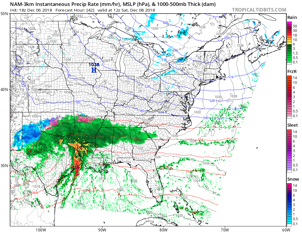
Quite the battle going on just now, a lobe of our big suppressing Canadian HP air mass and our SLP, looking impressive getting organised in the deep southwest. https://weather.cod.edu/satrad/exper/?parms=continental-conus-10-48-1-100-1&checked=map&colorbar=undefined -
December 8-10, 2018 Winter Storm
Jet Stream Rider replied to Orangeburgwx's topic in Southeastern States
Sure has and a good point. Note though there is no GoM or CAD in effect for that region like there will be in our area. -
December 8-10, 2018 Winter Storm
Jet Stream Rider replied to Orangeburgwx's topic in Southeastern States
Delayed onset for Raleigh north and east. Happy for the SC upstate folks though, looks like early onset and quite a pasting. -
December 8-10, 2018 Winter Storm
Jet Stream Rider replied to Orangeburgwx's topic in Southeastern States
Impressive amount of moisture coming in off the Pacific into the southwest and feeding into our system as it begins to get organized. Once the vortex moves east and begins to tap the GoM, it looks to be substantial. The early finger is further east and south than I anticipated this morning. https://weather.cod.edu/satrad/exper/?parms=continental-conus-14-48-1-100-1&checked=map&colorbar=undefined -
December 8-10, 2018 Winter Storm
Jet Stream Rider replied to Orangeburgwx's topic in Southeastern States
Yes^ Thanks Grit. The Euro at 96 looks weird, just drops the low back south and east and the temps, why is there no 850 crash across the Carolinas as the low departs ots? Edit - it may just be the 24 hour intervals throwing me off. -
December 8-10, 2018 Winter Storm
Jet Stream Rider replied to Orangeburgwx's topic in Southeastern States
1005 south of Hatteras. In the areas that stay frozen that would be a good bit of snow and sleet already down. -
December 8-10, 2018 Winter Storm
Jet Stream Rider replied to Orangeburgwx's topic in Southeastern States
It is a bit early, but later in the run the low gets far enough north and just off the southern NC coast that the warm nose turns everything in the coastal plain and the eastern Piedmont to cold rain. -
December 8-10, 2018 Winter Storm
Jet Stream Rider replied to Orangeburgwx's topic in Southeastern States
Preferably the low would be a little more suppressed, but still a very nice and rather rare setup -
December 8-10, 2018 Winter Storm
Jet Stream Rider replied to Orangeburgwx's topic in Southeastern States
I think it could. My thinking is that once it is located in the gulf at a specific time, the models can adjust, and its a milestone in the evolution of the system. Looking at the energy now on the coast of southern California, it just looks so slow. Of course the surface low will form out front of it, and we need that surface low in the gulf or at least along the shoreline. For the forum members that want to see snow, we need it to stay suppressed. And I want to see if it is early or late to that point, and that will effect things down stream. -
December 8-10, 2018 Winter Storm
Jet Stream Rider replied to Orangeburgwx's topic in Southeastern States
I want to see where and when the slp becomes established in the gulf as a marker and see what the models say then. That is supposed to happen around 12z Saturday. Right now the energy coming on shore in socal is so slow, I'm a little concerned it will go up the backside of the suppression.
-
December 8-10, 2018 Winter Storm
Jet Stream Rider replied to Orangeburgwx's topic in Southeastern States
That cold HP push looks stout to me, and it is a large scale feature. I think the wedge will be there for at least a good portion of the favored areas, and far out east as well. Then it will just depend on how far north the slp and ull go. -
December 8-10, 2018 Winter Storm
Jet Stream Rider replied to Orangeburgwx's topic in Southeastern States
The NAM used to be biased heavy on qpf, but was adjusted and now maybe is biased a bit light, is that correct? I do think the level of that initial hit will be important, both the over running which may serve to only moisten the column, and the actual precip from the slp. Then we have the backside ull to deal with. Looks like a broken period of precip over 2 days rather than a continuous period of precip. -
December 8-10, 2018 Winter Storm
Jet Stream Rider replied to Orangeburgwx's topic in Southeastern States
Looking at the real time movement of air masses, there is a big push south by the arctic air mass with accompanied upper level energy and you can see why this system is modeled to be suppressed. However the slp has yet to form in the gulf and we know it will want to press north with waa. Its unclear how this will resolve. Interesting to see how well the models do with it. https://weather.cod.edu/satrad/exper/?parms=global-northernhemi-10-48-0-100-1&checked=map&colorbar=undefined -
December 8-10, 2018 Winter Storm
Jet Stream Rider replied to Orangeburgwx's topic in Southeastern States
Our wave just now slowly crawling onshore southern California. The event could be 2 or 3 more-or-less separate periods of precip from Sunday - Tuesday as we get overrunning out ahead of this wave and the slp that will develop ahead of it as well. https://www.tropicaltidbits.com/sat/satlooper.php?region=atlpac-wide&product=wv-mid -
December 8-10, 2018 Winter Storm
Jet Stream Rider replied to Orangeburgwx's topic in Southeastern States
Its a good point Brick. However; remember that the models are forecast *guidance* and not an absolute representation of reality. And we have seen them be very wrong many times, as recently as last year. I hope we both get a foot though! Cheers. -
December 8-10, 2018 Winter Storm
Jet Stream Rider replied to Orangeburgwx's topic in Southeastern States
If the surface low turns up the coast like most of them do, then yes there will be a warm nose well inland. If the slp is a slider, mainly moving east like has been modeled now for many days and the CAD is established, then there will likely be no substantial warm nose. -
December 8-10, 2018 Winter Storm
Jet Stream Rider replied to Orangeburgwx's topic in Southeastern States
NAM dewpoints shows the wedge out to 84 -
Southeast Sanitarium - A Place to Vent
Jet Stream Rider replied to Jonathan's topic in Southeastern States
My goodness, after having problems completing its runs the past few days, the FV3 must have blown a gasket! -
December 8-10, 2018 Winter Storm
Jet Stream Rider replied to Orangeburgwx's topic in Southeastern States
The global models may not be accounting for the CAD properly still. It can extend out to the coastal plain if the slp is indeed a slider and does not come up the coast. -
December 8-10, 2018 Winter Storm
Jet Stream Rider replied to Orangeburgwx's topic in Southeastern States
Does anyone have insight as to why the FV3 has had problems loading the last couple of days? Bothersome when its supposed to go operational any day now, right? -
December 8-10, 2018 Winter Storm
Jet Stream Rider replied to Orangeburgwx's topic in Southeastern States
Since the NAM is pretty good at modeling the CAD wedge here is a an animation showing the CAD becoming established via dewpoint on Saturday. -
December 8-10, 2018 Winter Storm
Jet Stream Rider replied to Orangeburgwx's topic in Southeastern States
I agree with the cautionary statements at this lead. It is encouraging though to see the basic setup of strong-ish and cold high pressure suppressing a southern slider of a surface low pressure. And its certainly fun to track these potentials with all our fancy and evolving digital modeling. Obviously it should be no surprise if most of us end up with cold rain, but there is at this point still a chance for some frozen precip types. We will see. Enjoy the ride. At least we are out of hurricane season for now! Cheers everyone for another winter season. -
In addition to those two 105's, I recall a 106 too I think at Cape Lookout. I'd like to see the officials too though to be sure.
-
They are currently under a tornado warning. Not seeing or hearing much about that locality specifically, but the whole of the area around Wilmington is in dire straits generally. Local reports and storm alerts: https://nwschat.weather.gov/lsr/#AKQ,CAE,CHS,FFC,GSP,ILM,JAX,LWX,HUN,BMX,EYW,MHX,RAH,RLX,RNK,TAE,TBW,MRX,MLB,MFL/201809130400/201809160433/0110
-
Water vapor shows that southerly motion that seems evident on radar maybe is not system wide. It does look like that eye wall remnant might make it to Charleston though. Look at the expansive push from the north of that banana high pressure ridge. https://www.tropicaltidbits.com/sat/satlooper.php?region=06L&product=wv-mid