

Jet Stream Rider
-
Posts
1,085 -
Joined
-
Last visited
Content Type
Profiles
Blogs
Forums
American Weather
Media Demo
Store
Gallery
Everything posted by Jet Stream Rider
-
Southerly component to the movement is evident lately, past 3 or 4 hrs or so. Myrtle Beach in the remains of the eye at the moment, and the remnant eye wall to their west looks still to have some potency.
-
I think it likely that yes, it will stay north and west of Myrtle Beach. But its close and the way it can wobble, hard to say. The main point though is that it did not go directly south and back over water before turning west into MB as some models showed.
-
Looks to be close to the border just now. Although still in the Tar Heel state I think.
-
Florence at twilight this evening. Note the flareups near Cape Lookout that will rotate through downeast and central NC. Impressive hurricane.
-
I would think so. That's exactly where I would expect them. Let us know if you can.
-
Thanks for the explanation Grit. That helps. Euro is known to overdo wind speeds, kinda like the NAM is (or was) known to overdo QPF. Euro seems best at long range positions.
-
Dawn as Florence makes landfall.
-
^ However, ECMWF nailed the general location of landfall 9 days out, before Florence was even a hurricane.
-
It really did. Almost like its rolling down the coast there just north of Carolina Beach. Learned last night an old friend was riding it out at Carolina Beach. Hope he is OK. Might actually get into the eye.
-
Landfall Wrightsville Beach
-
As the eye contracts and collapses, Florence rolls along the coast and does appear to have a slight southward motion in the westward track. Eye wall onshore. Looks like landfall near Masonboro Island, between Wrightsville Beach and Carolina Beach is immanent.
-
Really has. Almost like its blown apart. Like an eye wall replacement and Florence is developing a huge eye.
-
Via radar, the eye wall appears to be very close to and closing on the Surf City area of Topsail Island.
-
Florence is taking a rather remarkable position in Onslow Bay.

-
That outer eyewall structure is stretched across most of the Onslow Bay beaches. That structure or band has hurricane force winds in it. The Wrightsville Beach and Carolina Beach area should be in it in an hour or so.
-
Report of sustained 75 and gust to 92 just east of due north Cape Lookout at station KNCDAVIS2

-
Looks like Cape Lookout and soon parts of Emerald Isle will be in what one could consider an outer eyewall.

-
At dusk Florence is still east of Cape Lookout

-
Emerald Isle is in play, might be too far east. I suspect any of the Onslow Bay beaches could get a landfall or part of the eyewall on shore.
-
Yeah, that last north move makes me think Cape Lookout rather than Cape Fear. Doubt it will be that pronounced though, but something like you say is certainly on the table. Surf City maybe.
-
It could be a wobble. Might wobble due west next, might not. Time will tell. https://www.tropicaltidbits.com/sat/satlooper.php?region=06L&product=wv-mid
-
NAM 3km shows landfall near Wrightsville Beach at 12z Friday

-
For New Bern, if Florence is in Onslow Bay, I'd expect gusts easily over 50mph perhaps hurricane force gusts even and heavy rain. Just some wind and rain does not sound like a reasonable forecast.
-
This is what I was thinking. Looks to be coming in high and hot. A little north and a little faster than NHC advisory. Its tricky visually out in the ocean, if there is a variance I'm sure model runs and new advisories will account for it, but it sure is nerve racking thinking its high and hot with so little room for error.
-
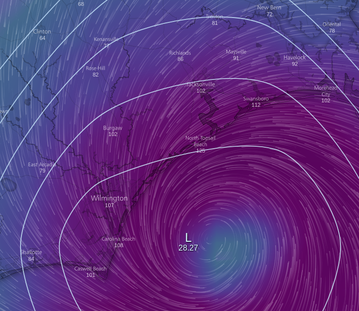
That is wise. I think we will all be watching on Friday to see position and movement. Position changes will make a difference well inland as we have discussed. Note that the wind field including the extent of tropical storm force winds and hurricane force winds is expanding in the real time analysis of Florence. Also note that there is nothing in the current GFS run that contradicts the NHC products.


