SolidIcewx
-
Posts
1,577 -
Joined
-
Last visited
Content Type
Profiles
Blogs
Forums
American Weather
Media Demo
Store
Gallery
Everything posted by SolidIcewx
-

Pre-Christmas (Dec 21-23rd) Winter Storm Part 2
SolidIcewx replied to Chicago Storm's topic in Lakes/Ohio Valley
Well my screen door got frozen shut. My front door is west facing -
Pre-Christmas (Dec 21-23rd) Winter Storm Part 2
SolidIcewx replied to Chicago Storm's topic in Lakes/Ohio Valley
4-8 north of m59 and 1-3 for metro Detroit dry slotted nice -
Pre-Christmas (Dec 21-23rd) Winter Storm Part 2
SolidIcewx replied to Chicago Storm's topic in Lakes/Ohio Valley
Mines at 69 -
Pre-Christmas (Dec 21-23rd) Winter Storm Part 2
SolidIcewx replied to Chicago Storm's topic in Lakes/Ohio Valley
We would have a monster on our hands -
Pre-Christmas (Dec 21-23rd) Winter Storm Part 2
SolidIcewx replied to Chicago Storm's topic in Lakes/Ohio Valley
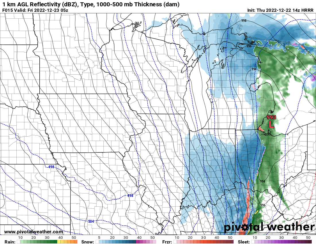
Accuweather it says 29.43 which is 996mb I was gonna say holy sheet -
Probably will lol
-
This one was definitely a roller coaster
-
Pre-Christmas (Dec 21-23rd) Winter Storm Part 2
SolidIcewx replied to Chicago Storm's topic in Lakes/Ohio Valley
Exactly we have a masochist mentality -
Pre-Christmas (Dec 21-23rd) Winter Storm Part 2
SolidIcewx replied to Chicago Storm's topic in Lakes/Ohio Valley
Taking bets on a dry slot for the DTW area? Excited for the transition here -
Pre-Christmas (Dec 21-23rd) Winter Storm Part 2
SolidIcewx replied to Chicago Storm's topic in Lakes/Ohio Valley
We shall see when it gets to DTW -
Pre-Christmas (Dec 21-23rd) Winter Storm Part 2
SolidIcewx replied to Chicago Storm's topic in Lakes/Ohio Valley
Im normally in the overdone crowd but feel this time it’s a tad under done. -
Pre-Christmas (Dec 21-23rd) Winter Storm Part 2
SolidIcewx replied to Chicago Storm's topic in Lakes/Ohio Valley
Gut tells me if it bombs and goes over Lake Erie we will be in for it -
Pre-Christmas (Dec 21-23rd) Winter Storm Part 2
SolidIcewx replied to Chicago Storm's topic in Lakes/Ohio Valley
DTX afd with nothing about amounts. Still not thinking of sustainable blizzard conditions is likely. -
Pre-Christmas (Dec 21-23rd) Winter Storm Part 2
SolidIcewx replied to Chicago Storm's topic in Lakes/Ohio Valley
Dry slotting in MI also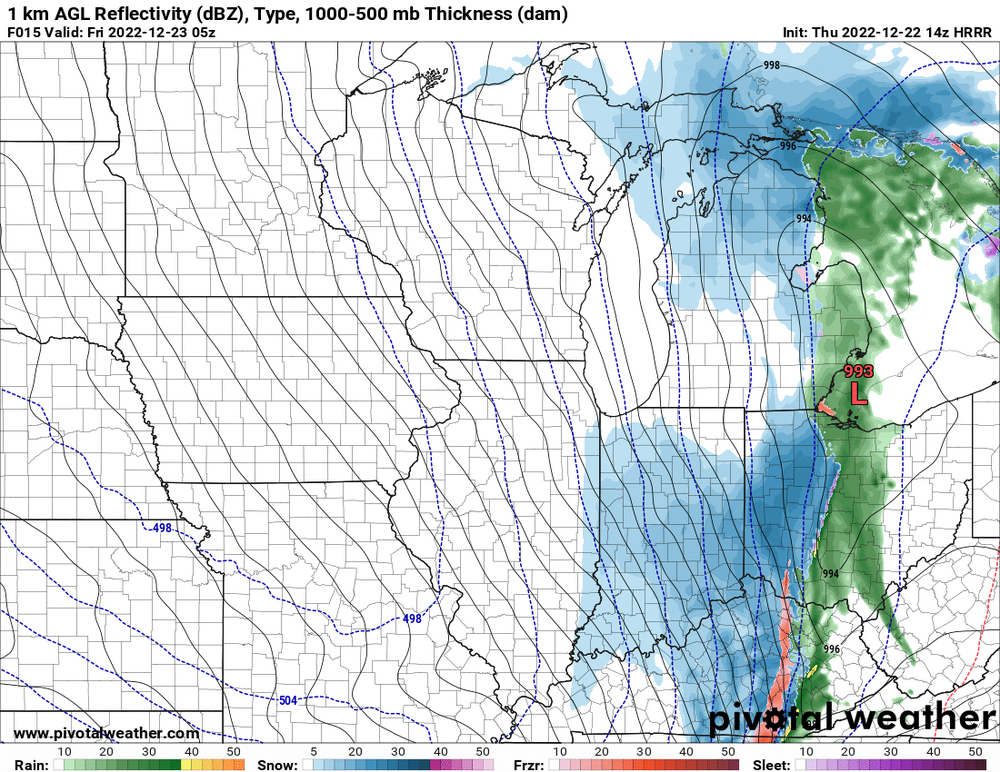
-
Pre-Christmas (Dec 21-23rd) Winter Storm Part 2
SolidIcewx replied to Chicago Storm's topic in Lakes/Ohio Valley
Got my full pot of my Kenyan dark roast coffee let’s get this show going! -
Pre-Christmas (Dec 21-23rd) Winter Storm Part 2
SolidIcewx replied to Chicago Storm's topic in Lakes/Ohio Valley
If they win out they won last 6 of 7. Young team also. Would be wildcard spot -
Pre-Christmas (Dec 21-23rd) Winter Storm Part 2
SolidIcewx replied to Chicago Storm's topic in Lakes/Ohio Valley

-
Pre-Christmas (Dec 21-23rd) Winter Storm Part 2
SolidIcewx replied to Chicago Storm's topic in Lakes/Ohio Valley
I know I’m laid back like a dead fly right now and excited regardless -
Pre-Christmas (Dec 21-23rd) Winter Storm Part 2
SolidIcewx replied to Chicago Storm's topic in Lakes/Ohio Valley
How big of drifts you think? -
Pre-Christmas (Dec 21-23rd) Winter Storm Part 2
SolidIcewx replied to Chicago Storm's topic in Lakes/Ohio Valley
I agree in my earlier post 4-8 not 2-4. I feel like it’s a false sense of security for the normies -
Pre-Christmas (Dec 21-23rd) Winter Storm Part 2
SolidIcewx replied to Chicago Storm's topic in Lakes/Ohio Valley
For the middle part of the state -
Pre-Christmas (Dec 21-23rd) Winter Storm Part 2
SolidIcewx replied to Chicago Storm's topic in Lakes/Ohio Valley
Ouch -
Pre-Christmas (Dec 21-23rd) Winter Storm Part 2
SolidIcewx replied to Chicago Storm's topic in Lakes/Ohio Valley
-
Pre-Christmas (Dec 21-23rd) Winter Storm Part 2
SolidIcewx replied to Chicago Storm's topic in Lakes/Ohio Valley
I haven’t seen the afd I’ll look at it now. That’s my thinking. Waiting to pull the trigger on that -
Pre-Christmas (Dec 21-23rd) Winter Storm Part 2
SolidIcewx replied to Chicago Storm's topic in Lakes/Ohio Valley
That’s what I got in my head also