

TimB
-
Posts
17,206 -
Joined
Content Type
Profiles
Blogs
Forums
American Weather
Media Demo
Store
Gallery
Everything posted by TimB
-

Pittsburgh/Western PA Summer 2022 Discussion
TimB replied to Ahoff's topic in Upstate New York/Pennsylvania
Definitely very localized. AGC saw over an inch earlier and I’m pretty sure I’ve seen over an inch imby in the last couple hours, but PIT is still sitting at a T for the day. -
Pittsburgh/Western PA Summer 2022 Discussion
TimB replied to Ahoff's topic in Upstate New York/Pennsylvania
Speak for yourself, lol. -
Pittsburgh/Western PA Summer 2022 Discussion
TimB replied to Ahoff's topic in Upstate New York/Pennsylvania
Incredibly, PIT’s high today will be pretty close to the last two days. -
Pittsburgh/Western PA Summer 2022 Discussion
TimB replied to Ahoff's topic in Upstate New York/Pennsylvania
Those storms are on PIT’s doorstep already. You might end up disappointed. -
Pittsburgh/Western PA Summer 2022 Discussion
TimB replied to Ahoff's topic in Upstate New York/Pennsylvania
Pretty on par with yesterday temp-wise through noon, but yesterday didn’t have cloud cover and storms and still only hit 88. I think this is part of the system that dropped another half foot of rain on parts of Missouri overnight, so the chance of excessive rainfall is definitely there. WPC has us in a slight risk and there’s a flood watch out to our south and west where the ground is more saturated. -
Pittsburgh/Western PA Summer 2022 Discussion
TimB replied to Ahoff's topic in Upstate New York/Pennsylvania
It’s all good, we’ll get to 90 today. There’s no way rain and storms will hold us back, right? -
Pittsburgh/Western PA Summer 2022 Discussion
TimB replied to Ahoff's topic in Upstate New York/Pennsylvania
Let’s not lose sight of the fact that today is the last day with normals of 83/64, tomorrow it goes back to 83/63 and begins the slow descent toward winter. -
Pittsburgh/Western PA Summer 2022 Discussion
TimB replied to Ahoff's topic in Upstate New York/Pennsylvania
Going to be the 2nd straight year where June got at least 3 degrees warmer than July. -
Pittsburgh/Western PA Summer 2022 Discussion
TimB replied to Ahoff's topic in Upstate New York/Pennsylvania
If I had to guess, too many 5-min obs of 90 to have not gotten there at least once, but I guess we’ll see in an hour or so. -
Pittsburgh/Western PA Summer 2022 Discussion
TimB replied to Ahoff's topic in Upstate New York/Pennsylvania
It was running even with or slightly ahead of AGC for most of the day, but AGC has since reached 91. Looks like the hourly obs at 2:51 was 89 so good chance we squeeze out another degree or two if we didn’t already at some point within the past hour. -
Pittsburgh/Western PA Summer 2022 Discussion
TimB replied to Ahoff's topic in Upstate New York/Pennsylvania
PIT is going to somehow fall short of 90 again today, isn’t it? -
Pittsburgh/Western PA Summer 2022 Discussion
TimB replied to Ahoff's topic in Upstate New York/Pennsylvania
Definitely an MCS that produced damage over a pretty significant distance. These are the SPC storm reports for yesterday, which I believe are mostly attributed to two separate MCS that tracked across different regions. I could see where that word would be used.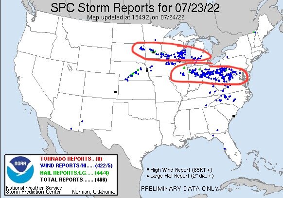
-
Pittsburgh/Western PA Summer 2022 Discussion
TimB replied to Ahoff's topic in Upstate New York/Pennsylvania
Looks like PIT got to 89 before that was brought to a screeching halt. You know what they say about wish in one hand, sh*t in the other. -
Pittsburgh/Western PA Summer 2022 Discussion
TimB replied to Ahoff's topic in Upstate New York/Pennsylvania
Would say Sunday is pretty much a lock at this point. Tomorrow looks like a decent chance too. -
Pittsburgh/Western PA Summer 2022 Discussion
TimB replied to Ahoff's topic in Upstate New York/Pennsylvania
Would guess tomorrow and Saturday would be a struggle to get there but Sunday really looks hot on some models if clouds and rain don’t prevent us from maximizing potential. -
Pittsburgh/Western PA Summer 2022 Discussion
TimB replied to Ahoff's topic in Upstate New York/Pennsylvania
90 at PIT today seems dead in the water. Do we get there this weekend? -
Pittsburgh/Western PA Summer 2022 Discussion
TimB replied to Ahoff's topic in Upstate New York/Pennsylvania
Seems we have a solid shot at 90 on Wednesday and maybe a chance somewhere around Friday or the weekend, but this pattern looks warm and humid and perhaps rainy at times, but not a massive heat wave. -
Pittsburgh/Western PA Summer 2022 Discussion
TimB replied to Ahoff's topic in Upstate New York/Pennsylvania
At first I thought maybe the HRRR badly underestimated cloud cover on those runs where it got us to 91 but that doesn’t seem to have been the case. Didn’t dive into the details of how it got us to 91 when it had us under cloud cover all day. That said, 80 if we’re lucky. -
Pittsburgh/Western PA Summer 2022 Discussion
TimB replied to Ahoff's topic in Upstate New York/Pennsylvania
GFS is advertising the mid/upper 90s heat for next weekend the last few runs. Then again, this weekend is going to be a bust compared to what was forecast/modeled as recently as midweek. Going to be a lot of disgruntled casuals if they didn’t check the weather for a couple days and assumed this weekend would be summery. -
Of course not. From what little I’ve read from him, he seems as serious about wanting BN temps year-round as I am.
-
Dude, you know it’s totally something I’d do, so no offense intended.
-
Hopefully @Ahoff took the time to vote in this silly poll. I know it would irk him if some random upstater saw 10 90+ days, especially if we manage not to.
-
Pittsburgh/Western PA Summer 2022 Discussion
TimB replied to Ahoff's topic in Upstate New York/Pennsylvania
Nice little somewhat unexpected storm last night for those of us that were lucky enough to be in its path. -
Pittsburgh/Western PA Summer 2022 Discussion
TimB replied to Ahoff's topic in Upstate New York/Pennsylvania
0z GFS brought back the big heat too, but mostly beyond 240. -
Pittsburgh/Western PA Summer 2022 Discussion
TimB replied to Ahoff's topic in Upstate New York/Pennsylvania
My thought on this would be that severe wind is much more common overall than severe hail or tornadoes, so it would stand to reason that the month with the most severe wind gusts would be the month with the most severe overall, and I could see that being July.

