

TimB
-
Posts
15,053 -
Joined
Content Type
Profiles
Blogs
Forums
American Weather
Media Demo
Store
Gallery
Posts posted by TimB
-
-
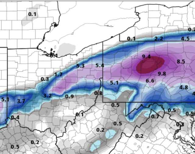
0z HRRR is a buzzkill.
-
2 minutes ago, Burghblizz said:
Calendar day is misleading. The 2 15”+ storms in that period straddled calendar days. 2.5 and 2.6 of 2010 got 10+” each day I think.
Also, most of us got real close to a foot 12.20 during the same day. I also got 13” in 12.03 (living in Penn Hills) during a single calendar day. Official total fell short, but eastern AGC got walloped in about 8 hours.
We don’t always knock those out of the park, but they get a lot leaner as you head southwest down the Ohio river.
Calendar day in and of itself can be misleading, but comparing calendar day records at one location vs another will give you a good idea of which location has better storm climo, which I think is what he was going for.
-
22 minutes ago, Ahoff said:
In classic Pittsburgh fashion the advisories are spreading from New Mexico up the Ohio River to Cincinnati, skips us and then starts again to the east. Just classic, lol.
Outside of lake enhancement in NW flow, we have upper south/lower midwest snow climo but northeast advisory/warning criteria.
-
 1
1
-
-
21z RAP is still a beaut.
-
Not sure how much stock anyone puts into the ICON, but improvement to 2-3” at 18z after it had been very consistent in less than an inch for several runs.
-
18z GFS trended back to decent. 3 hours of good snow to get us a low end advisory type event.
-
NAMs also slid SE.
-
19 minutes ago, north pgh said:
I think we are looking at a 1-3 event with most of it falling while I'm asleep which are not my favorite storms. Wake up, shovel and then watch it start melting Tuesday afternoon. Yawn.
Probably won’t even have to shovel.
-
Euro may have put the final nail in the coffin.
-
I know the RAP can’t be trusted at this range or really any range, but it does drop 9” in 6 hours including a couple hours with 2-3” rates.
-
1
-
-
8 minutes ago, RitualOfTheTrout said:
I agree, diurnal minimum for temperatures can only help. To bad we can't get a couple hours of clear sky to radiate. The last week or so that probably helped skew this warmth a bit as we still managed to drop into the 20s a few nights.
Even with all that radiational cooling we’re still sitting at +13.2 month to date. Just behind 1925 (at a different observing site) for warmest first 10 days of Feb ever.
-
 1
1
-
-
15 minutes ago, Rd9108 said:
I mean doesn't help when Tim who is from my area comes in your forum and stirs the pot....
As a second straight winter that is a complete and total failure for the eastern US becomes more and more of a possibility, it’s getting harder and harder to be positive and to not be cynical.
-
This thing is dead. CTP jumping the gun on issuing a winter storm watch with their already piddly 5” criteria compared to the 6” criteria the entire rest of the northeast uses, seems like false hope.
-
 1
1
-
-
1 minute ago, TheClimateChanger said:
Looks pretty solid to me, especially with 10:1 ratios.
We won’t get 10:1 ratios, it depicts temps being above freezing the entire time snow is falling.
-
Ok, technically it still gets us a decent total, but is this at all promising?
-
And there it goes. Stick a fork in it.
-
15 minutes ago, Rd9108 said:
18z euro north again fwiw. Need to see some type of bleeding to the north stopped tonight or tomorrow or else this thing is going to Youngstown/Cleveland. NAM is next up.
Once the bleeding starts, it never stops. We know this by now. Another wasted storm and likely another wasted winter.
-
1
-
-
1 hour ago, Blizzard of 93 said:
18z Blend looks good.

Note that this is through 2/21.
3-4” of snow in the southern half of PA outside the mountains over a 10 day period in February is approximately climo.
-
What a dumb winter. Can’t believe we got two of these in a row, and this one is somehow worse than last year, which was the worst winter that’s ever occurred here.
-
27 minutes ago, Rd9108 said:
Gfs not budging. The low was slightly south of 12z before transfer but the area is just flooded with warm air. My guess is the gfs is most likely gonna be right unfortunately. It just seems like in recent years anytime there is any sign of warm air/warm tongue that it's always north of even the models. Any hope is the cold air pushes further south than progged/more confluence. I'm not saying this one is over, it's just that we most likely willnnot win in this scenario unless we see some better trends...
It’s over. 6z GFS had the 6-8” line clipping a portion of the county, at 18z no one in Allegheny gets more than 3-4.
-
18z NAM has us in a good spot but it continues to tick north. I’m worried we’re in a precarious spot and this is just part of a bad trend.
-
1
-
-
Razor thin margins, but love when this gets put in the point and click.
That said, the Euro took a slight shift north at 12z. Far northern Allegheny county is still fine, but the rest of us are riding the slop line.
-
14 minutes ago, Burghblizz said:
Was just looking at that. Could be another sign that the it’s GFS Op versus the world.
The depth maps are meh, so I’m thinking it’s bad temp profiles and tough to get accumulation anywhere close to 10:1 even with a mean of 7”, but who knows.
-
GEFS mean looks awesome.

Pittsburgh, Pa Winter 2023-24 Thread.
in Upstate New York/Pennsylvania
Posted
Yep. Looking like we’re losing the NAM too. Entire precip shield misses us SE.