

TimB
-
Posts
15,052 -
Joined
Content Type
Profiles
Blogs
Forums
American Weather
Media Demo
Store
Gallery
Posts posted by TimB
-
-
Went up to northwest PA and watched the total eclipse. Interesting that the partial eclipse didn’t drop the temp at all at PIT, I thought that was expected even at 97% totality. Looks like Erie went 69 to 55 with the eclipse.
-
 1
1
-
-
On this day last year it was 85 degrees. Today it’s snowing.
-
1
-
-
19 minutes ago, TheClimateChanger said:
They screwed that up. Whatever they did, it excluded non-leap years. 2020 is actually in 16th place.
-
Year to date precip is currently in 2nd place behind 2018, which of course was the record year (but a large amount of that precip from 1/1 through early April fell as snow).
-
Hell of a way to run a moderate risk.
-
Yesterday’s final official tally of 2.68” makes it the wettest spring day on record for Pittsburgh.
-
Obligatory “imagine if this was snow” post.
-
 1
1
-
-
And still lots of rain to come through.
-
10 hours ago, TheClimateChanger said:
Wow, pretty crazy. April 1901 still takes the cake though.
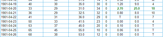
2.05 inches of precipitation, and 12.7 inches of snow on April 3, 1901.

Later in the month, 1.53" of rain on the 19th and an additional 2.24" on the 20th.
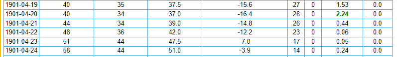
What a heartbreaker that must have been though for southwestern Pennsylvania, as parts of eastern Ohio saw up to 3 1/2 feet of snow. At least, the nearly 13" of snow earlier in the month would have provided some consolation.
Warren, Ohio
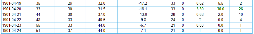
Gratiot, Ohio
That April 19th-20th period in 1901 now stands as the only two day period in April wetter than yesterday and today. Today has now become the 4th April day on record with 2”+ of precip.
-
This is now the wettest April day ever observed at Pittsburgh international, with 1.62” and counting observed since 1am. The official all time record for any April day is 2.34” on 4/14/1922. We’re up to 6th on the all time list.
-
2 hours ago, TheClimateChanger said:
Wow. Not sure I've ever seen it this high for our region.

Last Day 2 moderate risk for anywhere in PBZ’s domain was issued on 7/26/2014. That system ultimately produced 2 hail reports and 8 wind reports in PBZ’s area, so we dodged that one.
-
11 minutes ago, north pgh said:
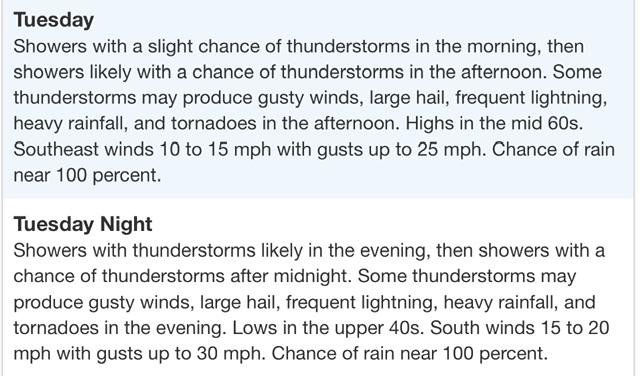
Flood Watch
National Weather Service Pittsburgh PA
148 PM EDT Mon Apr 1 2024

OHZ039-040-048>050-PAZ021-029-073-074-WVZ001>003-020345-
/O.EXA.KPBZ.FA.A.0003.000000T0000Z-240403T0000Z/
/00000.0.ER.000000T0000Z.000000T0000Z.000000T0000Z.OO/
Tuscarawas-Carroll-Coshocton-Harrison-Jefferson OH-Allegheny-
Washington-Westmoreland-Higher Elevations of Westmoreland-Hancock-
Brooke-Ohio-
Including the cities of Canonsburg, Monessen, Lower Burrell,
Malvern, Ligonier, Carrollton, Washington, Steubenville, Donegal,
Murrysville, Weirton, Dover, Greensburg, Wellsburg, Coshocton,
New Philadelphia, Wheeling, Follansbee, New Kensington, Latrobe,
Pittsburgh Metro Area, and Cadiz
148 PM EDT Mon Apr 1 2024

...FLOOD WATCH IN EFFECT THROUGH TUESDAY EVENING...

* WHAT...Flooding caused by excessive rainfall continues to be
  possible.

* WHERE...Portions of east central Ohio, including the following
  areas, Carroll, Coshocton, Harrison, Jefferson OH and Tuscarawas,
  Pennsylvania, including the following areas, Allegheny, Higher
  Elevations of Westmoreland, Washington and Westmoreland, and West
  Virginia, including the following areas, Brooke, Hancock and Ohio.

* WHEN...Through Tuesday evening.

* IMPACTS...Excessive runoff may result in flooding of rivers,
  creeks, streams, and other low-lying and flood-prone locations.
  Creeks and streams may rise out of their banks. Flooding may occur
  in poor drainage and urban areas.

* ADDITIONAL DETAILS...
  - Multiple rounds of showers and thunderstorms are expected
    through Tuesday evening. Each will have the potential to
    produce heavy rain, with a cumulative effect evolving to
    create increasing potential for excessive runoff with each
    successive round. Total rainfall estimates through Tuesday
    evening will likely reach 1 to 2 inches across the Watch
    area, with locally higher amounts up to 3 inches possible.
  - http://www.weather.gov/safety/flood

PRECAUTIONARY/PREPAREDNESS ACTIONS...

People in the watch area, especially those living in areas prone to
flooding, should be prepared to take action should flooding develop.
Monitor the latest forecasts and be alert for possible flood
warnings.

&&
Severe risk also seems to have really amped up with latest guidance.
SPC sounded the alarms with their latest outlook:
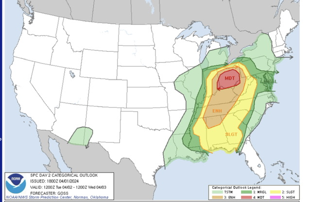
And PBZ introduced this to the zone forecast for Allegheny County:
-
Trying to figure out how PIT only topped at 96 in that heatwave.
-
1 hour ago, TheClimateChanger said:
When will be our first below normal month? Any guesses?
I’m going to go with August 2025. It’s the month that has gone the longest without being below normal (last time was 2017, which broke a streak of 18 straight above normal months), but it’s going to be a hot summer and won’t happen this year.
-
So far in 2024 we have had 17 days that were 15+ degrees above normal and 16 days that were below normal by any amount.
The last day that was 15+ degrees below normal was 5/3/23.
-
3 minutes ago, ChescoWx said:
LOL!!!! non statistical p-value over that long a period!!!
You’ll stop at nothing to prove your stupid little agenda. Trust me, the last time someone will think about these records you’ve meticulously been keeping for decades will probably be about 3 years after you’re dead, maybe less. Is it even worth it?
-
1 minute ago, ChescoWx said:
Nothing flawed in my all encompassing data LOL!! is all of the available actual non adjusted data and it shows no statistically significant warming at all....unless you apply the "post observation" NCEI adjustments!
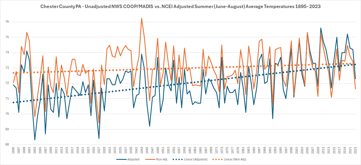
72.7 to 73.3 is still warming.
-
5 minutes ago, ChescoWx said:
I have been working with the great folks at the Delaware Environmental Observing System (Thanks to Chris!!) to add even more weather observation points and stations across Chester County PA. With the updated data and summer coming I thought I would run an analysis of Summer (June-August) temperatures across the County from 1895 through last summer (now with 25 Chester County Stations at least partially in the data since 1895 and 15 current observation sites included). Overall in the non-adjusted data there is only as expected normal cyclical warm and cool cycles but I thought I would show you a comparison of the post observation adjustment applied by the the National Center of Environmental Information (NCEI) who have applied 111 consecutive years of post observation adjustments to chill the actual observations to each and every summer from 1895 through 2005 and have every year since 2005 now applied a warming adjustment. As you can see in the trend lines the orange non-adjusted and blue adjusted paint a far different rate of our rate of warming.
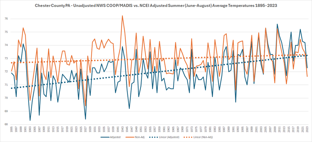
This doesn’t belong in regional subforums. But good to see you admit that your flawed data and the NCEI data both show warming.
-
10 minutes ago, TheClimateChanger said:
Wasn't a good year in western Pennsylvania either. I know Soergel's had to cancel their strawberry festival last year, although they did get some strawberries later in the season after it started raining again. Looking like fruit growers are going to have a tough time navigating this new climate. Spring just doesn't seem delayed enough anymore to retard plant growth sufficiently to counter the threat of spring frosts and freezes.
The flowers started poking through in early February just as they did last year, I’ve seen a lot of geese already returning north, it’s crazy.
The recent “cold” spell featured one below normal day at PIT (a whole 2 degrees below normal), and we’re sitting at +13 for the month to date. A 9th straight above normal month here is a lock, and it’s probably much the same in central PA, even if the anomalies this month haven’t been quite as big.
-
1 hour ago, PghPirates27 said:
Have the last 5 springs and summers been near the warmest on record?
Well, July 2020 was the warmest July and second warmest month ever recorded at the airport, only behind August 1995.
-
0.4” at the official observing site still keeps us 0.4” short of 1973-74. Below are the current standings for the 10 worst winters in the 75 or so years that obs have been taken at (near?) the airport.
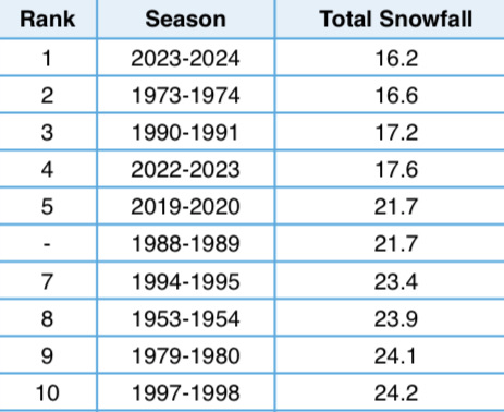
I still think we can squeeze out a half inch during the upcoming cold period and avoid setting that record, but it seems it’d be a tall order to get out of the bottom 5, three of which have occurred in the past 5 winters.
-
On 1/27/2024 at 10:16 AM, Itstrainingtime said:
And I am old enough to see the Association come full circle.
I grew up watching both the NBA and the ABA. The ABA was noteworthy for 2 things...they used a red, white and blue ball, and there was no defense. When the ABA merged with the NBA in the 1970s, coming into the Association was a whole bunch of high flying scorers. Julius Erving was one of the most famous. After that, scoring gradually started to come down to where teams would average right around 100 points. Then the late 80s and especially the 90s featured the bad boy Detroit Pistons and a whole new, physical style of play along with it. They had success and other teams followed. Suddenly games were ending 86-78 and the like.
Today's game leaves me feeling very conflicted. While I can appreciate the level of athleticism, the game has evolved into shootouts. Guys driving to the cup for an easy layup but instead firing the rock out to the perimeter for yet another 3. Defense is not emphasized until the 4th quarter. It's entertaining for a lot...the one thing that it isn't is "pure" basketball. And it's one of many reasons why I'm a former season ticket holder and have no plans on attending a single game this season.
That's my perspective as a 50+ year fan of the game. My 28 year old son can't get enough of it, so there's definitely an appeal to some.
So today’s sixers game was a godsend.
-
35 minutes ago, Itstrainingtime said:
You need to get out of Harrisburg if you hate wind...I have no idea how accurate this is, but I just found this online that supposedly is current:
I don't think (?) I've had anything even close to 40mph yet.
That looks like it pulls the most recent hourly obs from the ASOS. Look at that 63 gust in Philly.
-
1
-
-
5 minutes ago, CoraopolisWx said:
Euro still interested in the 18th-19th time period. Op showing some fantasy snow.
You ain’t kidding, it really gets that thing going.
Pittsburgh/Western PA Spring 2024
in Upstate New York/Pennsylvania
Posted
Hmm. Is PIT cooking the books?