TimB
-
Posts
17,206 -
Joined
Content Type
Profiles
Blogs
Forums
American Weather
Media Demo
Store
Gallery
Everything posted by TimB
-

Pittsburgh/Western PA Spring 2023 Discussion
TimB replied to Ahoff's topic in Upstate New York/Pennsylvania
Just kidding. Those 6 hours of rain/snow obs yesterday were recorded as 0, not T. -
Pittsburgh/Western PA Spring 2023 Discussion
TimB replied to Ahoff's topic in Upstate New York/Pennsylvania
Looks like PIT had some obs this morning that included snow, so with the graupel showers yesterday that’s two T’s to start the month. PIT has never observed frozen precip 3 days in the same May (though my backyard did in 2020, and it was actual snow all 3 times). Could it happen tomorrow? -
Pittsburgh/Western PA Spring 2023 Discussion
TimB replied to Ahoff's topic in Upstate New York/Pennsylvania
Just poured graupel here for a few minutes. -
Pittsburgh/Western PA Spring 2023 Discussion
TimB replied to Ahoff's topic in Upstate New York/Pennsylvania
Looks like we’ve sealed the deal on a 4th straight above normal month to start 2023, though the back end of the month kept us far from surpassing 2017. I wonder if this year ends up being like 2020 where once the switch is flipped, the heat is on after a cold spell in early May. -
Ouch.
-
Pittsburgh/Western PA Spring 2023 Discussion
TimB replied to Ahoff's topic in Upstate New York/Pennsylvania
30s would be unprecedented. The coldest May high at PIT is 40, on 5/9/1966 (by far the snowiest May day on record here at 3.1”) and on 5/9/1923 (the third snowiest May day on record at 0.7”). I think I mentioned this back in 2021, but five of the 10 coldest May highs in Pittsburgh occurred on the 9th, including 2020 and 2021. Odd quirk. -
Pittsburgh/Western PA Spring 2023 Discussion
TimB replied to Ahoff's topic in Upstate New York/Pennsylvania
Very likely snow flurries. Looks like PIT was at 42 at the time of the one singular obs that reported snow. I was driving back from NW PA at that time and temperatures were similar (low 40s), and p-type was definitely snow flurries at times in the vicinity of I-80. -
Pittsburgh/Western PA Spring 2023 Discussion
TimB replied to Ahoff's topic in Upstate New York/Pennsylvania
Just kidding. If the euro is right, upper 70s are once again attainable next week. More cutters. This pattern just doesn’t change. -
Pittsburgh/Western PA Spring 2023 Discussion
TimB replied to Ahoff's topic in Upstate New York/Pennsylvania
Back half of April looks like largely below normal temps, though temps do surge towards yet another mini heat wave later this week as yet another storm comes up through the lakes in this, the 5th month in a row of this pattern. -
Pittsburgh/Western PA Spring 2023 Discussion
TimB replied to Ahoff's topic in Upstate New York/Pennsylvania
I just did a quick twitter search and it looks like this might be the first one since April 2018 for the immediate Pittsburgh area. -
Pittsburgh/Western PA Spring 2023 Discussion
TimB replied to Ahoff's topic in Upstate New York/Pennsylvania
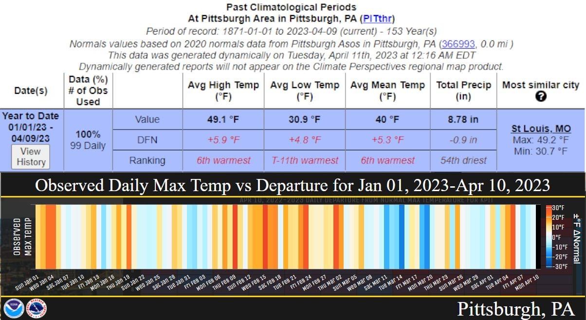
NWS posted a graphic. Just a casual 6 degrees above normal highs for the year to date, with probably six more days with well above normal highs incoming.
-
Pittsburgh/Western PA Spring 2023 Discussion
TimB replied to Ahoff's topic in Upstate New York/Pennsylvania
17.6” -
Pittsburgh/Western PA Spring 2023 Discussion
TimB replied to Ahoff's topic in Upstate New York/Pennsylvania
I’m not going off 5 minute obs this time, NWS issued a record report saying 85. -
Pittsburgh/Western PA Spring 2023 Discussion
TimB replied to Ahoff's topic in Upstate New York/Pennsylvania
Looks like the high at PIT is going to be 85. Second earliest on record, behind 4/2/2010. -
Pittsburgh/Western PA Spring 2023 Discussion
TimB replied to Ahoff's topic in Upstate New York/Pennsylvania
Higher risk was to our west, so if the upstream watch in a more favorable environment for severe is only a severe thunderstorm watch, it’s not likely we’ll be at risk for tornadoes. -
Pittsburgh/Western PA Spring 2023 Discussion
TimB replied to Ahoff's topic in Upstate New York/Pennsylvania
Quite a number of PWS around the county that are at or very close to 90. -
Pittsburgh/Western PA Spring 2023 Discussion
TimB replied to Ahoff's topic in Upstate New York/Pennsylvania
Record has been tied. That makes 7 of the first 10 days of April with daily records since 2010. -
Pittsburgh/Western PA Spring 2023 Discussion
TimB replied to Ahoff's topic in Upstate New York/Pennsylvania
Going to be hard to get really warm with all this cloud cover. -
The Ides of March end of Winter 2023
TimB replied to paweather's topic in Upstate New York/Pennsylvania
Was thinking about this yesterday. It only takes about a +6 departure to set an all time hottest April, right? I’m about ready to lock that one in with what’s coming later next week, unless we get an actual below normal stretch later in the month. Only fly in the ointment here is that in these dry stretches, overnight lows might cool off pretty well. -
Pittsburgh/Western PA Spring 2023 Discussion
TimB replied to Ahoff's topic in Upstate New York/Pennsylvania
Daily record is 83. The record earliest: 85: 4/2/2010 86: 4/11/1930 87: 4/17/1896 88: 4/18/1896 (actual high that day was 90) So if we overperform, we’re talking about temperatures a full week or two before they’ve ever been observed. -
Pittsburgh/Western PA Spring 2023 Discussion
TimB replied to Ahoff's topic in Upstate New York/Pennsylvania
HRRR says 88. I think that’s too high, but we shall see. -
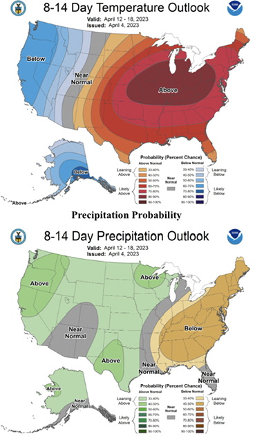
The Ides of March end of Winter 2023
TimB replied to paweather's topic in Upstate New York/Pennsylvania
CPC 6-10 and 8-14 day outlooks are all in on the hot and dry forecast.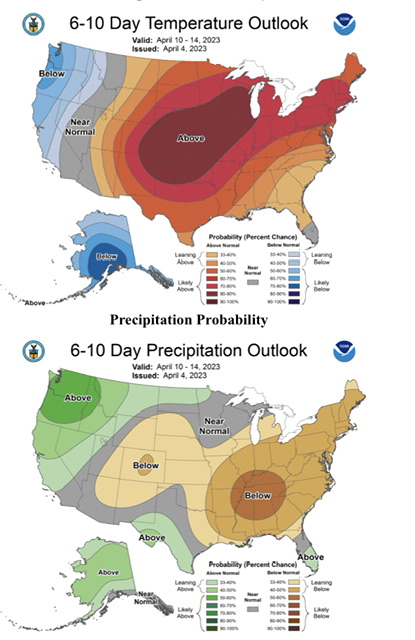
-
The Ides of March end of Winter 2023
TimB replied to paweather's topic in Upstate New York/Pennsylvania
Cruz is a beast. Hopefully they keep him around for awhile. -
The Ides of March end of Winter 2023
TimB replied to paweather's topic in Upstate New York/Pennsylvania
They’re certainly looking like they are headed in the right direction, but I’ve said that far too many times in the last 30 years. -
The Ides of March end of Winter 2023
TimB replied to paweather's topic in Upstate New York/Pennsylvania
You are not going to use me as a pawn to devolve this place into sports talk.