

TimB
-
Posts
15,130 -
Joined
Content Type
Profiles
Blogs
Forums
American Weather
Media Demo
Store
Gallery
Posts posted by TimB
-
-
Also, the early look at the Thursday system on the 0z NAM doesn’t look like it’s going to be a winner.
-
37 minutes ago, Ahoff said:
I don’t know what to tell you?
My phone’s weather app, which I think runs off of TWC, keeps it all snow tomorrow on the hourly.
I don’t know where any weather app or otherwise is getting the idea that this will be all snow anywhere in Allegheny County. With that being said, this is not met bashing in the slightest. Many of us have performance reviews in our jobs, and it’s certainly the case that in a government-run bureaucracy like NOAA, there would have to be some level of performance accountability when it comes to the NWS. Not that they can’t get a forecast wrong, as surely it’s obvious that there is a lot more uncertainty in what they do for a living than what most of the rest of us do. But maybe one of the performance indicators is “how many times did X forecast office issue a warning and have to downgrade it to an advisory (or vice versa)?” If you can keep it a warning, even if it’s marginal, then it keeps your office from getting dinged when it gets audited by the higher ups, who don’t necessarily care that there is way more forecast uncertainty in a place like Pittsburgh than there is in, say, Phoenix. After all, a NWS forecast office did once get reprimanded for something as arbitrary as correcting erroneous information provided by a political figure on the track and impact of a hurricane.
-
 1
1
-
-
53 minutes ago, Ahoff said:
Well they were saying up to .2” of ice early, if we trend less snow, I imagine more ice is on the table. Why can’t we just leave it as is?
Instead, they’ve left the 3-6” intact and still 0.1-0.2 of ice, despite many model runs to the contrary between the initial warning and the recent update.
-
1
-
-
Just now, KPITSnow said:
My god you’re worse than me. What was your former name on here?
No former name on here, actually. Just thinking about warning criteria, and usually when 2” of snow and 0.1-0.2” of ice are expected, an advisory is issued. Does already having issued a warning change that thought process?
-
1
-
-
3 minutes ago, KPITSnow said:
This still is going to be a pain in the ass ice event and the WSW is extremely valid still.
Aren’t the WSW criteria for ice 1/4” or more? Do we legitimately think we get there?
-
So at what point does the NWS downgrade our warning to an advisory? 4 hrs after precip onset?
-
 1
1
-
-
1 hour ago, RitualOfTheTrout said:
Yep, I remember multiple times as a kid watching 6pm news for weather ( I used to time them so I could catch all 3 stations, 2,4,11) with a storm projected to be all snow only to hear the pinging on my bedroom window and that feeling knowing warm air was winning. I didn't understand any of the causes then, probably why I was so interested to learn more about the science as I got older.
I was this kid too. Go to bed with them predicting 6-8 inches of snow, thinking school would be closed and then waking up to rain and disappointment.
-
2 minutes ago, KPITSnow said:
Ehh it is Climo here. These events we always see an adjustment northwest as we approach the events. I know I can remember events where we went from 10 degrees to over 40 in a 24 hour span.
This still looks like a major winter event though, just not likely to see much snow.
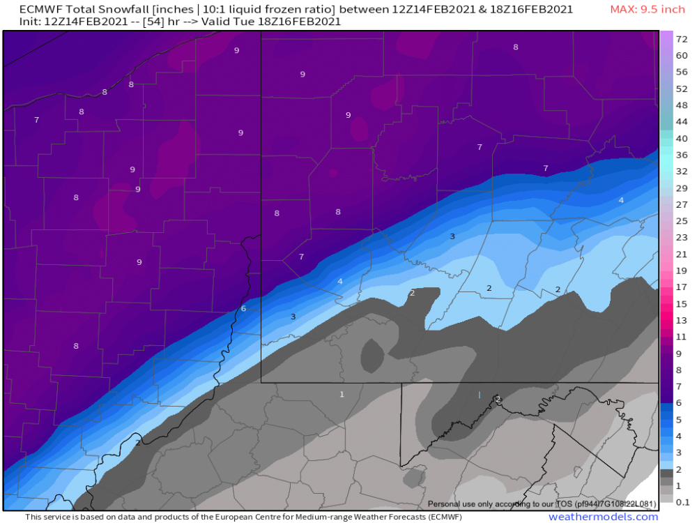
The Thursday system still looks better for snow. GFS wants to give us 5” and half an inch of ice still and drag the low right across our area. I’ll believe it when I see it.
-
Wait, they issued a graphic at 1:23 and another less than a half hour later?
-
13 minutes ago, Ecanem said:
This cutoff is giving me nightmares from previous years.
That cutoff would give us a pretty nice “official” total, though the vast majority of folks would see far less than what goes into the record books.
The NWS trended amounts down as they should have, but non-weather enthusiasts who only use things like TWC to know what the weather will be like are being misled to believe they’ll get 6-12” of all snow (up from an earlier forecast of 4-8), even in places like the South Hills.
-
33 minutes ago, RitualOfTheTrout said:
That will help a little, but I just don't get excited over ice depicted unless it's at least in the 20s. Ice formation releases latent heat too so you need some mechanism to replenish the cold. Don't get me wrong even a tenth of ice on an untreated surface can be a disaster, but you won't be seeing trees snapping and power outages if the NAM temperature profile verifies.
I don’t want trees snapping and power outages, lol.
Edit: I guess power outages would give me a day off of work, but pretty sure that’s just a waste of a day of leave.
-
Just now, RitualOfTheTrout said:
NAM is the warmest model, 32-34 during bulk of the precipitation and gets into the upper 30s before the cold swings back through. Even if we stay at 31, ice accretion will not be efficient. Sure there will be a glaze but it's not a 1:1 ratio like those maps project.
Even falling onto cold ground/snow after a week plus of being below freezing at the sfc?
-
44 minutes ago, north pgh said:
This may be a split allegheny county special. I can see eastern allegheny county getting 2-4 and western allegheny county 4-8.i think everyone gets 1-3 from the first waive. I hope with the second waive if we do mix we get sleet over freezing rain. Then maybe another 1-3 backend overnight Monday. It’s going to be interesting to say the list. I think we stay all frozen however. I just can’t see plain rain. We haven’t been above freezing for 2 weeks. Just my guesses. We’ll see.

Aside from the NAM, most models do keep the vast majority of precip frozen (to the extent that freezing rain is “frozen”). But the ice storm threat is increasing.
What product will the NWS issue? I would think a warning rather than an advisory for 2-6” of snow SE to NW and a much higher risk of 0.25” ice.
-
12 minutes ago, Rd9108 said:
Euro does the same thing. This might end up being our bigger snow threat than tomorrow.
Or the GFS could push the low back through Indy like it did yesterday, or it could keep shifting east. Way too many options.
-
GFS keeps trending East with the later system, rams the low directly through our area. Could be interesting.
-
33 minutes ago, Ahoff said:
See I disagree with 17-18. It had a cold snowy December, and white Christmas. Very cold and snowy January, even had you below 0 weather. A cold and snowy March, and even 7" of snow in April (which I actually didn't care for at that point). Febraury was the only issue of the winter.
That was a memorable cold snap. I guess my memory immediately went to the 10+ inches we received in late March that melted almost as quickly as it fell, and yes, the snow in April, which inflated our totals a little. That was one of the longest cold snaps in recent memory, and I remember shoveling snow in brutal cold.
-
27 minutes ago, Ahoff said:
Sure, but looking at the details of the year, 2nd snowiest December ever, after years of awful Decembers. Whitest Christmas of all time, when a white Christmas is rare. A January, that despite not be overtly wintery was cold (overall), and didn't reach 50 at all, and had near normal snow. A February, that half way through has reached average snow amounts, has not yet reached 40, likely won't for a few more days at least, and has had at least 4 inches of snow on the ground the whole month. And overall, a season that featured, as of now 4 storms of more than 6". Probably the first time in a while that's happened.
We could see a season with 50", but snow that melts the next day. Looks like by your analysis that's a good year. I wouldn't qualify it that way. This will be one of my great winters. not the best (that was 09-10). But great for sure.
I agree. ‘17-18 comes to mind for a season with a high total but wasn’t a real winter.
-
11 minutes ago, MikeB_01 said:
The NAM does a few things. It generally has way more ice than other models. It also can have a tendency to overdo the rate at which the system deepens. These rapidly deepening systems tend to over amplify and then push the rain snow line further north.
NWS discussion from 8 am this morning still in the camp of the forecast remaining on track.
I’ll be watching the HRRR and the SREFs (my favorites) today to see how things look.
.Well the 12z HRRR certainly didn’t go in our favor either...
NWS will keep the watch intact, as is, until they issue an advisory this afternoon for 2-4” of snow and up to 0.1” of ice.
-
15 minutes ago, Ahoff said:
Pretty much every threat this year has been a success. None of us can deny that. A miss like this was inevitable at some point, it happens at a minimum once a season. There's still more snow to be had over the next few weeks I'm sure. We've had a great season. I'm happy. Of course I do want more snow, lol. I'd love 10 more inches tomorrow, but I'm content overall.
I think that’s an undeniable fact, with one caveat. If this snow season ends with the 49.7 inches we’ve had so far, and nothing more (unlikely, as it’s almost certain we’ll get at least a little more), I would classify that as a good but not necessarily “great” season. If that’s the final season total, it’s slightly above average. To use a sports analogy, if you will, a snow season with 49.7” would be like a Steelers season where they go 11-5 and win one playoff game before getting eliminated (certainly better than recent years, but “good, not great.”)
-
2 minutes ago, Ahoff said:
So we definitely don't "have it" until it starts falling. The trends are bad, no denying, but it's also still not locked in. There's really no reason it doesn't trend back at the last few hours and there's no reason it doesn't trend us into a dry slot for most of the storm.
So from an information and knowledge standpoint, how does the NAM usually do at this juncture? Does it typically run warm? Cold? I’m not all that well versed in the NAM.
-
So there we have it. An inch and a half of snow from the first wave, almost half an inch of ice from the second wave, and it all melts and then some when temperatures rise into the mid to upper 30s Tuesday morning, if the NAM proves to be correct. Won’t sensationalize and say take down the watch this time because that amount of ice is no joke.
-
5 minutes ago, Rd9108 said:
Pretty crazy just like 10 days ago we were talking about possible record breaking cold and now we sweating rain for the same time period.
Yeah, remember when the models thought we’d wake up to -19 this morning?
-
5 minutes ago, KPITSnow said:
NAM looks like a complete torch.
Edit: Not a complete torch, but an absolutely ugly ice storm.
Half an inch of ice and not one flake of snow in the second wave? And the track of the low has officially entered Ohio. Forget about a Youngstown special, this is a Fort Wayne special.
-
4 minutes ago, KPITSnow said:
Man, it’s really good that we have had a good winter...otherwise we’d probably be in total meltdown over areas around Houston getting more snow than us potentially.
They’re also under a wind chill warning because “wind chills may fall below zero.”

We’re now up to 47 states that have an active watch/warning/advisory for either snow or cold, and 18 of those are for the entire state.

Western Pa / Pittsburgh area Winter Discussion ❄️☃️
in Upstate New York/Pennsylvania
Posted
In short, the Euro gives us the temperature profile we need for the Thursday storm. Other models give us the same garbage as today’s storm, albeit with a little more snow.