

TimB
-
Posts
15,378 -
Joined
Content Type
Profiles
Blogs
Forums
American Weather
Media Demo
Store
Gallery
Posts posted by TimB
-
-
NAM makes Monday look mildly interesting. Very quick hitter but 3”.
-
2 hours ago, Rd9108 said:
Well unless the CMC is correct looks like we take a break from tracking for a week. Next week is interesting atleast on the GFS and para. Para has a bowling ball that just goes W to E and destroys Baltimore with 2ft. Its been a fun a year of tracking. I'm used to sitting here and looking at models and just hoping a SSW takes places or modeled blocking actually holds in place.
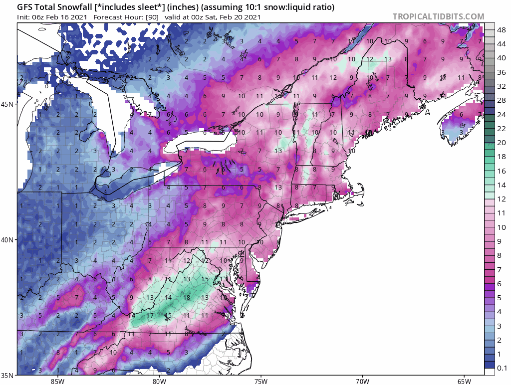
Euro gives us mostly rain, GFS brings a snowstorm of epic proportions through central NC and gives us nothing, and the Para gives the aforementioned blast of snow to MD/VA. In other words, the models have picked up this storm and there’s still a ton of time to either cash in or not.
-
20 minutes ago, SteelCity87 said:
Well then lol
The threshold for “this storm didn’t suck” was admittedly set incredibly low at this point, but I think we managed to not even meet that threshold.
-
 2
2
-
 1
1
-
-
7 minutes ago, Ecanem said:
Don't look now, but the Euro and GFS are sniffing another storm next Friday.
All I ask is that if it’s not going to happen, the models pick up on it no later than Sunday so as not to get our hopes up and crush us.
-
It’s always a curse when the models agree and tease us with a D9 storm like they did with this one. Hopefully they don’t do that again. Oh wait...
-
 1
1
-
-
8 minutes ago, CoraopolisWx said:
That freezing drizzle Saturday night put a nice crust on the pack, maybe it survives until the next cold stretch.
That’s a tough ask, depends on which model is closer on the extent of warmth later next week. GFS keeps us not terribly far above freezing but the Euro sends our temps soaring. Maybe the snowpack will slow that down too, though.
-
9 minutes ago, Rd9108 said:
I like March snowstorms. They seem to overperform for us and we usually don't worry about temps it seems. I remember a few years ago one March storm where we got like 8 inches overnight. Quick hitter but gone in a day.
Believe it or not, that’s the only time this century and only the second time since the big one that we’ve gotten 6” of snow on a single calendar day in March (3/21/18).
-
1 hour ago, dj3 said:
I was pleasantly surprised how well we maintained snow pack during the days leading up to Monday night. Overcast and cold temps makes a difference for sure. I'll still enjoy lighter events if we get them in March but if we're not tracking a big storm I wouldn't be upset about a quicker flip to spring.
I hope it’s not a third straight year with less than 1.5” of total snowfall beyond March 3rd, but as long as spring is seasonable and not the kind of year where you have to turn the a/c on well before Memorial Day, I can live with that.
-
5 minutes ago, RitualOfTheTrout said:
March has to be my least favorite month aside from it being cutoff low season which can produce some interesting storms. Outside of something special its really a blah month.
This. It’s essentially April, except sometimes instead of getting 1-2” inches of snow overnight that melts before noon the next day, you can sometimes get 4-8” of snow that melts before noon (think 2018).
-
8 minutes ago, RitualOfTheTrout said:
This is the criteria for an advisory:
A winter storm event (sleet, snow, freezing rain, snow and blowing snow, or a combination of events) is expected to meet or exceed local winter weather advisory criteria in the next 12 to 36 hours but stay below warning criteria. Criteria for snow is 4 inches or more in 12 hours or less covering at least 50 percent of the zone or encompassing most of the population. Use "mid-point" of snowfall range to trigger advisory (i.e 2 to 5 inches of snow = advisory). Criteria for ice is any ice accumulation less than 1/2 inch over at least 50 percent of the zone or encompassing most of the population. Winter Weather Advisory can also be issued for black ice. This is optional.
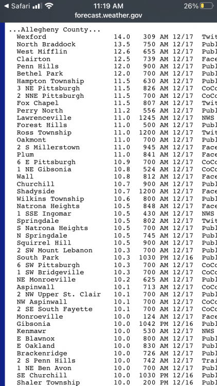
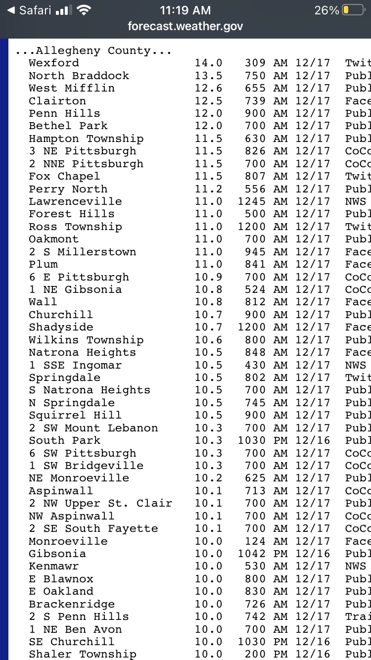
Given the significant NW cutoff will create a steep gradient that will bisect Allegheny county I wouldn't be confident that 50 percent of the county sees 4 inches or more based on current guidance would you? Now my understanding is these rules aren't absolute, they can for example take into account time of day (evening / morning commute) or be more likely to issue an advisory for the first snow of a season etc. Based on the text in the discussion and the fact we probably see the biggest amounts overnight into the morning commute and it's likely the city gets at least 3 inches they will probably expand to include Allegheny unless as we draw closer the short term models lower totals further.
I don't get all riled up over what the NWS posts for any area in terms of warning / advisory etc. It doesn't affect what we actually get and usually they err on the side of issuing something to raise awareness over doing nothing.
Ah, that’s where I was mistaken. Somewhere along the line I believed 3” was an advisory here. And no, I don’t have confidence that any part of Allegheny County gets 4”. I think it’s possible in some SE areas of the county, but not with any confidence.
Maybe I’m getting confused because my mind’s current threshold between “this storm sucked” and “this storm didn’t suck” is at about 3”.
-
So the NWS thinks most of Allegheny County gets 3-4” of snow (so low end advisory level), but isn’t confident enough to issue an advisory. That doesn’t bode well.
-
1 hour ago, Ahoff said:
I certainly wouldn't have said that, lol. We were still in a decent space for a few inches yesterday, hell the snow all day yesterday amounted to a sneaky 1.6". 2" should be pretty easy to achieve, but anything can happen.
I would say I went to bed last night thinking there was a very real possibility if not likelihood that yesterday would officially be the snowiest day of this week. It’s still a possibility, but a lot less likely.
Edit: this was before I saw the 12z Euro.
-
54 minutes ago, Ahoff said:
Yeah, that seems odd to me. I imagine they are erring on the side of caution with crazy totals, which is what made the initial 6-8" call they had all the more crazy.
The mesos look good to me. They're not spitting out high amounts, but looking at temperatures we should have some higher ratios that can boost the totals. Also, for as long as the NAM 12km and NAM 3km have it snowing the lower totals seem too low. I don't know, we'll see.
If you told me last night our eventual total would be 1” or less, I would have agreed. I’m not so sure I do now. It’s definitely not a warning level event but it’s probably at least borderline advisory, especially if the highest rates are centered around a rush hour.
This goes back to the NWS’s idea of “how do we message this so as not to confuse the general public?” that we’ve been talking about all week. Because the general public, especially in Pittsburgh sees “2-3 inches” and thinks, “that’s nothing, it might be a minor inconvenience to me but not much more, and besides, the NWS was badly wrong last time,” whereas if they see “2-3 inches with the heaviest rates centered around the evening rush” (though I don’t think that’s when we get the best rates, even if that’s what NWS implies), then a little more caution is involved. Because we know that a quick 2-3 inches at rush hour will cripple the evening commute around here. -
38 minutes ago, Ecanem said:
GFS doesnt show major snow totals for us but it also brings the rain/sleet line almost to allegheny county.
GFS has stopped the bleeding with the SE shift, which is good.
NWS still wants to keep the “heavy at times” wording in for both tomorrow and tomorrow night in our area, despite forecasting only 2-3 inches of snow.
-
15 minutes ago, Rd9108 said:
So basically we are back to our norm of being too far south or north to get snowfall.
Seems that way. This winter helped me forget this is the way it almost always works in Pittsburgh, so I wasn’t as prepared as I would normally be for the models completely falling apart with a drastic last minute NW shift, then two days later completely falling apart with a drastic last minute SE shift.
It’ll be interesting to see what today’s final snow total is at the airport. Today could be the snowiest day of the week when it’s all said and done.
-
10 minutes ago, RitualOfTheTrout said:
The trend continues 00z GFS.

At this point, if I were a betting man, I’d bet against advisory level snowfall. Not saying I’d bet against snowfall at all (yet).
-
Any more SE shift at all and I think our chance at even advisory level snowfall is sunk.
I think NWS has me at about 3.8 on the point and click, which is roughly half of what I had as recently as this morning. This one is disappearing as quickly as yesterday’s storm, but in the other direction.
-
18 minutes ago, Ahoff said:
By mid-March, I'm in Summer mode, lol. Bring on the warmth.
Don’t get me wrong, I truly enjoy having four seasons, but summer is by far my least favorite of the four (at least from a weather perspective). The relentless heat and humidity is too much. No snow and very little severe weather to track, at least by the time you get to July/August, and the last few summers have lasted 4-5 months.
-
5 minutes ago, Burghblizz said:
Those Southern Ohio zones (which would figure to do similar to us with this) have a lower threshold. They can pop em up with 4”+ expected
Ah, I see the one for the Wilmington, OH forecast office is for 2-4 inches and a light glaze of ice. That would barely get us an advisory. Like I said earlier, at least the 7 people that live in Preston/Tucker County, WV (if any of them even like snow) will be satisfied with this storm.
-
There’s a notable gap in the watches somewhere...


-
1
-
-
3 minutes ago, Ahoff said:
They basically said that all of February would look like that too, back in January, lol. Actually they may have had the whole country warm for February.
I'm taking it a week at a time.
I actually saved this map from 1/31 because we constantly see ones with no blue, but we never see ones with no orange/red. It was incredible to see.

-
Well folks, Thursday may be it for awhile. We all know how long this pattern seems to persist every time it sets up the past few years.

-
Just now, Burghblizz said:
60 days ago...:-)
True. Was forgetting we won that storm in the North Hills, even if the “official” total was less than 12”.
-
5 minutes ago, dj3 said:
I would love to see something similar to 2010 again since I was too young to really remember much about Mar 1993 and Jan 1994. Obviously I love snow and enjoy the little/moderate events as well but the true big ones are what make the hobby so fun.
Likewise. I didn’t live here in 2010, unfortunately. I was old enough in March 1993 to know it was historic, but 8 year old me certainly wasn’t tracking the storm. So I have yet to track even a 12” snow event in Pittsburgh, unless I’m forgetting one.


Western Pa / Pittsburgh area Winter Discussion ❄️☃️
in Upstate New York/Pennsylvania
Posted
I’d be surprised if we get 3”, but I’d take 1-2, which most models seem to give us. Really depends on when the precip falls. If the bulk of it is before 12z, I’d bet on more snow than rain.