

SnowenOutThere
-
Posts
5,666 -
Joined
-
Last visited
Content Type
Profiles
Blogs
Forums
American Weather
Media Demo
Store
Gallery
Everything posted by SnowenOutThere
-
RDPS is significantly improved too (though not enough to help NOVA but Short Pump makes out like a bandit). It generally follows the positive aspect I've been highlighting which is the secondary bands of NS energy being modestly further west
-
So far it looks like it should at least hold from its 18z improvement I think. Still sorta does the Nam more connection with the low off western Mexico but seems like it should be fine for it.
-
I'm actually not quite sure what goes wrong as I agree that on paper that what happens out west and to the north looks better with less push/suppression of the NS. My best guess is something happens either internally with the shortwave or the interaction between it and the low of Mexico causes its energy to become more stretched and further eastward based. Looking at it more the only real difference seems to be that the shortwave remains a bit more connected to the low of Mexico and there are slightly stronger H5 winds which as @CAPE pointed out hurts us by stretching out the vort. 0z wind map 18z wind map
-
Thank you so much for this post, and sorry for the confusing initial wording. This also helps clarify to me a how the arctic front theory of storm formation (while generally "wrong") can make some sense as I assume it comes from seeing the stretch between air masses as a line of vorticity that eventually spins up into a concentrated area to force surface low formation. Of course, it doesn't actually get into why that happens but it makes more sense regardless. If I read your post right in sensible terms we are in the best place for surface low development when we have a strong baroclinic boundary to our south (aids in convergence though my course didn't go too much in depth with it so I'll just accept a stronger temp gradient is better), a jet streak that is either positioned to the northwest (right entrance which I guess may be associated with a negatively tilted trough usually?) or a jet to our southeast (maybe more for broad bowl patterns?), and a condensed ball of vorticity (shortwave) to act as the initial perturbation in the system. I also know that 500mb low wise a sharper amplitude with shorter wavelength wave tends to increase vorticity though I don't actually know why (to be honest my ability to connect vorticity to low pressure is sketchy at best and I'd appreciate resources to find that connection). Additionally, If you have any websites to look at the upper air patterns for past storms I'd love to dive into that to see examples of this.
-
That makes sense, but as Cape alluded to with the flow stretching the vorticity apart is it best for a developing low to be displaced from the strongest winds? I know that oftentimes the jet isn't able to "round the base" of a trough and once it does it indicates a matured/max developed storm and is that the logic behind it or am I mistaken?
-
I edited my previous post to give you a shoutout for those posts as they are what got me largely to where I'm at! Thank you for them. BTW the best part about being a student is that while doing these breakdowns is procrastinating it feels infinitely better than doom scrolling as I can rationalize it as learning for future classes.
-
To be honest the upper winds is where my knowledge gets confused as we went over how the jet forms (I can tell you why the jet increases on the northward heading side of an upper low and decreases when heading south) but didn't go over the practical effect on the surface. I'm currently trying to research it on my own but generally it confuses me as my intuition says that areas of lift should form where winds are accelerating in the upper atmosphere (as it induces lower level lift as air is pulled into the upper flow) yet I know from the 4 quadrant model that understand I have is flawed. Additionally, I would've expected that stronger upper winds generally encourages cyclogenesis and didn't consider that it could actually hurt consolidation (which admittedly does make sense). Basically, what upper wind profile would actually be conductive to forming a strong surface low pressure?
-
Thank you! We finally got to the actual H5 Jet stream ageostrophic wind etc part of my course last month! Of course, it wasn't anything crazy but its given me just enough tools to begin identifying how the upper air connects to the surface and making predictions. That said, I'm very confident that this is very much a Dunning-Kruger effect where I know just enough to make broad forecasts and identify what I we need models to trend and make predictions from an earlier hour to but I am unable to "correct" model behavior as I just don't have the confidence (wait till Spring 2027 and Synoptic met for that) to do so. So with that said please feel free to correct any mistakes I make as it literally might save my grade! I also should of course mention that a lot of this knowledge was built through posts by you @psuhoffman @brooklynwx99 @high risk @WxUSAF@Terpeast @Bob Chill alongside the many other more occasional in depth breakdowns by our "on-event" posters. It's just this class has finally given me just enough to start synthesizing my own analyses so genuinely thank you.
-
Doesn't look the 18z Euro should cave too much if at all so far.
-
Yep, need the Friday storm resolved first
-
It's all about the interaction out West around the hour 90-110 mark. We need the leftover energy in the far Southwest to aid in the development of our shortwave coming out of the NS. Looking between the 18z and 12z shows how 18z just wasn't able to pull everything together fully and left too much energy out. Ofc, the NS digging and whatnot matters as well but I'd really like to see the energy out west be pulled East more (though this probably won't be resolved until our Friday system goes by as it is interacting with that storm as well). 18z 12z
-
Dont think the Monday wave is going to be as good as 12z sadly. Less consolidated so far.
-
Tbh that wave has nearly infinitely more potential as it’s not 3 separate ones in a trench coat pretending to be a real storm
-
GFS looks to be pretty similar to 12z so far (though out West is possibly slightly improved?) Didn't matter, if anything the run is a slight step backwards with the energy being more ribbony
-
Doesnt matter as we lose the thermals hard. I think if we're gonna get frozen we need shortwave one to work out
-
That would be the shortwave three option to get a storm which I mean maybe? Though no way to know if it'll be accurate this far out.
-
It has an extra lobe of energy further east than the 12z run and generally has the NS flatter instead of spikier worse run but impossible to know if itll verify yet 18z 12z
-
Don't know if this will actually embed how I want it to but this is what I mean. You can really see the string of vorticity in the early-middle part of the loop that suppresses the flow to the east (hopefully we get that to trend less intense/further north). Then we can see the second part with the west getting flooded with unconsolidated energy which results in the shortwave collapsing between the flow to the south and the western push. https://imgur.com/a/Eloa7k7
-
In fairness we are 3 days from the event which is now solidly NAM range
-
Does anyone know how to successfully embed links to gifs or images into posts?
-
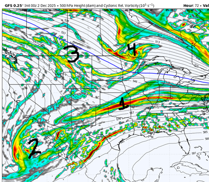
So, over the past couple days I've been quite the downer on this storm having a possibility of bringing widespread snow to the area. In the past I mainly felt this way as we were relying on a convoluted mess of shortwave interactions. However, in the past 12 hours modeling has moved to put us on a far easier path to victory as they reemphasize shortwave 1 (previously we were using shortwave 3 even days ago) as the dominant way to get precipitation into our area. Of course, it could shift the other way but this is exactly the trend we want to see. Lets take a look at the difference between the past GFS runs that leave us high and dry and the Euro/NAM camp that actually has a real storm. This GFS run shows our first shortwave that gets compressed by a combination of factors. We have energy flooding the west (feature 3) and another NS shortwave which really is the main issue (feature 4 note the string of vorticity connecting to feature 3). Feature 2 is just sorta helping with moisture transport and imo isn't overly important. So, we run this forward in time and we see this: Feature 1 is now basically nonexistent as it is a ribbon of vorticity from Texas to Virginia. So, the real push northward of precip is instead by feature 2 and 3/4 interacting with each other which frankly was never going to workout unless we got a minor miracle (and the thermals would be bad from the extended return flow anyways and was shown by the GFS having rain where there was any precip). It was from this perspective that I believed there was no way we could get a storm into the Mid-Atl Lets compare to the Euro/NAM: We already have shortwave 1 way more clearly defined and less strung out. This is what actually causes a storm in this run not shortwave whatever the hell the GFS does! Notice how much simpler this is! its just a shortwave out west moving east into cold air! We can legitimately do that! Of course, features 3 and 4 are still there but they are held back and give us a little more breathing room. By Friday morning itself the difference is even more clear as there is still a consolidated mass of vorticity and that creates our storm. What we need to look for is for features 3/4 to slow down or dig south at a sharper axis to encourage the first shortwave to consolidate. For instance see the difference between 6z having the energy out northwest of our storm being flat across Chicago and the 12z having it spike north south west of Chicago area and encourage development downstream instead of suppressing it. I think that piece of energy is the main thing we have to watch (the Nam 3k has an amazing depiction of how a flatter and faster NS energy will suppress the flow but sadly I don't have the upload space but please go and make one yourself), if it manages to hold back or dig further south while maintaining a good axis I think we're in the game to get a nice snow day Friday. TDLR: I am no longer Debbie downing Friday. We got a legit shot if the Euro/Nam is right in the handling of shortwave 1 as the primary piece of energy.
-
Making the thread as we speak
-
I can start it
-
Though seriously, we are in a far better spot than we were for Friday last night. We are now actually just tracking shortwave one and not shortwave 3 which I identified a couple days ago as being a way less complicated setup.
-
Man the progression is so interesting modeling wise to how we score I want to type it up but I have chemistry homework I gotta do before my 2pm Env. Sci. class


