

SnowenOutThere
-
Posts
5,666 -
Joined
-
Last visited
Content Type
Profiles
Blogs
Forums
American Weather
Media Demo
Store
Gallery
Everything posted by SnowenOutThere
-
We broke Tropical Tidbits output scaling
-
Almost looks like its going for a triple phase in the plains. Or it could just crush it... NVM
-
@stormtracker I believe your services are needed
-
Scratch that as others have pointed out it looks to phasing with the NS instead of being killed by it. This is exactly how the new CMC at 0z got us a complete ice storm as it jacked the whole track way north. Though the 12z CMC seems to be a bit further south so it may crush us
-
CMC so far with a bit less suppressed of a south west though I doubt it fully can climb to us.
-
I was focused on the out west interactions but honestly I liked what the GFS did where we live. It showed another path to a snowstorm even if we fail our golden route. I like this second failsafe situation where we use the NS to create an eastern low pressure with all of the moisture to our south. Hopefully it won't need to come to this but I like that its there.
-
Lmao you're doing great I'm just here ranting about maps. Speaking of which we flirt for so long with a phase before it starts to retrograde back west. Though... I think it might setup for a different storm later with this look.
-
We are SO CLOSE. Regardless of what happens this run has been a major improvement over 6z
-
Next 20 hours determines if the GFS can pull through. The SW is so close to ejecting east and we need the bit of energy north of it to help it instead of cut it off
-
We don't have the same piece of NS coming down to help lift it out of the SW that the Euro has. I doubt we get a similar evolution to our big hits though an improvement from its own baseline is possible.
-
The resident UVA poster approves of this change
-
Physics based GFS has the SW a bit more east and less confluence in front. Generally seems to moving in the right direction but need to see what happens in the next 20 hours.
-
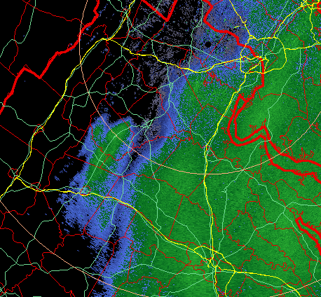
Wanted to ask you or any other met @Eskimo Joe @high risk @WxUSAF about what happened out near Charlottesville and Shenandoah yesterday. Seemed like on radar we got a localized bit of terrain enhancement with some sort of upper level boost. Was wondering if that is a common thing out here or was just some freak incident due to extremely favorable wind interactions with the mountains. I plan to also pester my microclimate professor about this on Tuesday. Either way was an extremely interesting evolution where I got a rather significant surprise .5ish inch of snow. Heres a radar screenshot from when it was happening
-
So far no major changes through hour 60. Going to need to watch the NS interaction coming up. Edit: Take this back as the Southern vort is slightly more eastward and slightly more north which cant hurt us.
-
Most important run of the GFS so far for 2026 running. Big difference I'm looking for is around the hour 100 mark with the handling of shortwave over the Pac NW that either cuts off our southern stream energy or kicks/phases it eastward. The 6z difference in Euro vs GFS shows it nicely. GFS on top Euro on bottom.
-
Also you know its a real threat when we got a bunch of mets posting in the thread!
-
Quick hit. Not great but a big improvement both H5 and surface.
-
Real question is who starts the thread
-
Just wait for the snow to ice event to end all ice events. To be completely honest that is the real worst case scenario from impacts perspective and not an unlikely one. Would be a significant snow storm followed by a bit of sleet than freezing rain which would actually accrete to everything with temperatures in the teens before crashing to near 0 with widespread blackouts from the storm. IMO this is what we gotta avoid from a “holy shit people will die” perspective.
-
My thinking is similar to yours. Personally I think we’re in a pretty good spot as of now considering that the AI GFS/Ukmet are almost too far north. Main thing I want to see out of today is the Euro and Euro ai to hold and have the CMC and GFS come closer to that solution. I think the way we get that is have the pv to our northeast be a bit less intense or (better yet though less likely) have a stronger low. That said, I wouldn’t want models to all suddenly jump way north today but just show increasing confidence a total miss to the south is unlikely.
-
KEY MESSAGE 2...The potential for a possibly significant winter storm has increased for this weekend, but uncertainty remains. The upper air pattern resembles what appears to be a very favorable pattern for a winter storm somewhere in the eastern U.S. heading into this weekend. Before that, a potent cold front pushes through the region late Thursday into Friday, followed by a reinforcing Arctic front late Friday into Saturday. This will lead to increasingly cold conditions each day from Thursday through the entire weekend. Well below average temperatures are forecast, especially by Sunday. In addition, some upslope snow showers are possible with each front. By the end of the week and especially heading into the weekend, the upper-level pattern becomes quite active in both the northern and southern branches of the jet stream. Model guidance is still very much all over the place in regards to exactly what comes of this, but there is growing consensus for an area of low pressure developing across the south-central/southeastern CONUS. Depending on when and where that area of low pressure develops, as well as where it goes after it does develop, there could be significant wintry precipitation across our area sometime next weekend. Uncertainty remains with this system, as there is some potential that strong Arctic high pressure could suppress the system south. However, that high (~1040 mb Arctic high) is also a source of very cold air; this likely remains in place due to a favorable -AO/-NAO blocking pattern. Meanwhile, there are an increasing amount of ensemble members that bring significant wintry precipitation to the region due to an amplified southern stream influence - something we have seen very little of so far this winter (typical of La Nina). The low may not escape as easily out to sea given the -NAO block. The nearby steady source of very cold air and the amplified southern stream occurring in tandem are what raise some red flags for significant wintry precipitation potential this weekend. The latest ensemble guidance is certainly on the upward trend in that regard, but that doesn`t mean it can`t swing back in the other direction. It will be key to monitor this threat closely in the coming days as the different parts of the system become better sampled by surface and upper air obs. Current model spread indicates an axis of significant snow/ice could be as far north as Upstate New York, or as far south as the Carolinas. Bolded some key parts of the afd
-
I was so confused when I woke up and saw snow outside before I remembered that yesterday happened
-
Sad how no matter what the models show it’ll always rain in Gaithersburg
-
I believe this would be a better run than the 0z was
-
Not really. It has a far norther storm but gets there differently than the ai gfs. Ai gfs is still primarily a west to east system that just gains some more latitude while the ukmet just rams the primary low up the Ohio valley to our west.


