Gordo74
-
Posts
227 -
Joined
-
Last visited
Content Type
Profiles
Blogs
Forums
American Weather
Media Demo
Store
Gallery
Everything posted by Gordo74
-
Central PA Fall Discussions and Obs
Gordo74 replied to ChescoWx's topic in Upstate New York/Pennsylvania
As a Gateway graduate during that time and as someone who was there during the "Justin King" debacle - it was just that. A debacle. King went to the school board early on and told them that they had to invest heavily in the football facilities or he was taking King elsewhere. Gateway did - gluttonously so at the direction of Smith. So much so that the academics suffered and still continue to 20 years later/never recovered. Just take a look at where they rank now amongst western PA schools - quite a far cry from just before Smith took over. There's no excuse to have Pentium 2's running Windows 95 when the new weight room has Xbox 360's on every TV. There was no money left for anything outside of football, but they had new everything all the time with everything paid for, despite other sports playing with broken down equipment and non-athletic organizations having to self-finance. Then Smith skedaddled as soon as King went to PSU and left Gateway in the lurch. No mentoring of anyone, no hope for continued success. Just trying every way he could to get King ahead. He was a diva and a selfish one at that, plain and simple. On top of that, and VERY UNFORTUNATELY, any time anyone said a word against him or his approach, it was turned into a race discussion. It had nothing to do with race imo, and everything to do with him taking the piss out of Gateway for all they were worth. I suppose he's done okay at PSU, but in Monroeville? He's still public enemy #1 for taking a Blue Ribbon school and shifting focus to football, wringing them dry, and taking the midnight train away. And that's from someone who went to Gateway AND Penn State. -
Pittsburgh PA Fall 2025 Thread
Gordo74 replied to TheClimateChanger's topic in Upstate New York/Pennsylvania
Looks like the cool down keeps getting bumped just to the horizon of the 10 day forecast and not lining up with precip. Ho hum. -
Pittsburgh PA Fall 2025 Thread
Gordo74 replied to TheClimateChanger's topic in Upstate New York/Pennsylvania
https://paweatheraction.com/polar-vortex-favorable-conditions-setting-up-a-cold-snowy-december/ Seems like there's the beginning of smoke. Hopefully something shapes up. -
Pittsburgh PA Fall 2025 Thread
Gordo74 replied to TheClimateChanger's topic in Upstate New York/Pennsylvania
There was a freeze warning here in Westmoreland a week or two before this one, hence my confusion. I believe it hit it too. Maybe not enough to be considered "killing"? -
Pittsburgh PA Fall 2025 Thread
Gordo74 replied to TheClimateChanger's topic in Upstate New York/Pennsylvania
Another freeze warning here in Westmoreland. I thought after the first one they consider the growing season "over" and then no more until next growing season? Can someone educate? -
Pittsburgh PA Fall 2025 Thread
Gordo74 replied to TheClimateChanger's topic in Upstate New York/Pennsylvania
Looks like we'll hit #4 here if forecast holds. Almost lost it yesterday, but got to 60.4F. -
Ended up with 3.2” of rain throughout the 12 hr period. The storm around 8:30 pm had a rate of nearly 4” an hour at a point.
-
Nearly 1.2” of rain today in about a 35 min span in Murrysville area. Tons of lightning/thunder too. Nice little daytime storm, but my AC has been working overtime with the warm nights.
-
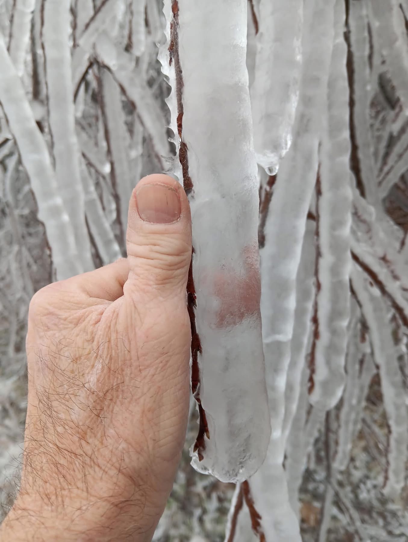
This freezing weather is no good for all the new growth out.
-
Pittsburgh/Western PA Winter 2024-2025 Thread
Gordo74 replied to Rd9108's topic in Upstate New York/Pennsylvania
Looks like the groundhog was wrong again aside from a little stretch. Long range is looking a lot more like spring than winter. -
Pittsburgh/Western PA Winter 2024-2025 Thread
Gordo74 replied to Rd9108's topic in Upstate New York/Pennsylvania
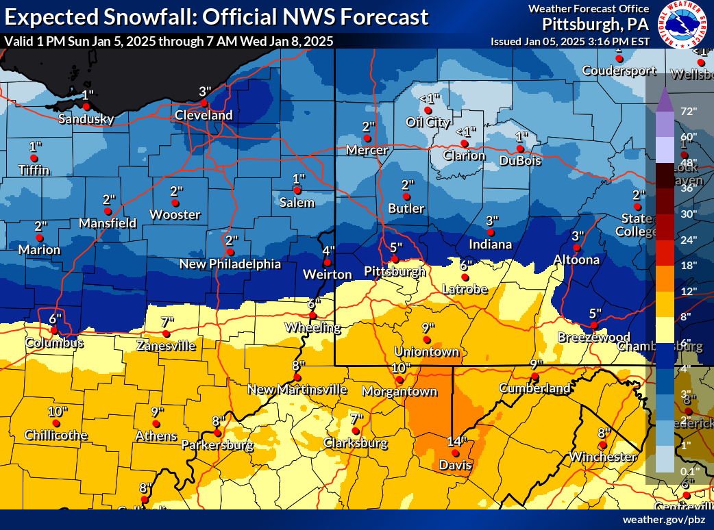
Interestingly Apple Weather (which seems to follow the Euro) has 13-16” for Pittsburgh area next week on Thursday with 22-27” in Somerset Co. Long way out to get excited about. -
Pittsburgh/Western PA Winter 2024-2025 Thread
Gordo74 replied to Rd9108's topic in Upstate New York/Pennsylvania
Weekend continues to trend warmer -
Pittsburgh/Western PA Winter 2024-2025 Thread
Gordo74 replied to Rd9108's topic in Upstate New York/Pennsylvania
Somerset Co on weds/thurs.
-
Interesting that this is roughly the same date range of our current stretch.
-
Pittsburgh/Western PA Winter 2024-2025 Thread
Gordo74 replied to Rd9108's topic in Upstate New York/Pennsylvania
Unverified PWS obs at Deal trailhead of the Allegheny passage was -21 at 7:38am. -
Pittsburgh/Western PA Winter 2024-2025 Thread
Gordo74 replied to Rd9108's topic in Upstate New York/Pennsylvania
We got around 1” yesterday but picked up an additional 3-4” overnight. The latter seemed to catch everyone off guard - some streets are not touched from the overnight snow near me. Pretty great event all in all. Now for the frigid cold. Hopefully the pipes are up for it! -
Pittsburgh/Western PA Winter 2024-2025 Thread
Gordo74 replied to Rd9108's topic in Upstate New York/Pennsylvania
Snowpack somehow held up today - went from around 5" to probably 1.5" left on the ground, but enough to keep things cold. Some patchy spots where the sun was blazing yesterday, but I'm hopeful that tomorrow will bring fresh new powder on top. -
Pittsburgh/Western PA Winter 2024-2025 Thread
Gordo74 replied to Rd9108's topic in Upstate New York/Pennsylvania
Have had heavy snow here in north Murrysville/Plum area with the band training back to mccandless. Easily the heaviest rates of the day and picked up a quick 2” on top of what fell this morning (1-1.5”) -
Pittsburgh/Western PA Winter 2024-2025 Thread
Gordo74 replied to Rd9108's topic in Upstate New York/Pennsylvania
Probably 2-3” here. A little disappointing but overall 5-6” for the Friday - Monday with no above freezing temps in sight. Nice to enjoy a white ground for winter! -
Pittsburgh/Western PA Winter 2024-2025 Thread
Gordo74 replied to Rd9108's topic in Upstate New York/Pennsylvania
Light snow here as well, but flying in with the winds coming from the east. -
Pittsburgh/Western PA Winter 2024-2025 Thread
Gordo74 replied to Rd9108's topic in Upstate New York/Pennsylvania
Lol an hour into an event and already throwing in the towel. You people are awful sometimes. -
Pittsburgh/Western PA Winter 2024-2025 Thread
Gordo74 replied to Rd9108's topic in Upstate New York/Pennsylvania
Looks like NWS bumped it slightly north..
-
Pittsburgh/Western PA Winter 2024-2025 Thread
Gordo74 replied to Rd9108's topic in Upstate New York/Pennsylvania
Absolutely is a win with these temps and already having 2-3” of snow on the ground imo. -
Pittsburgh/Western PA Winter 2024-2025 Thread
Gordo74 replied to Rd9108's topic in Upstate New York/Pennsylvania
Wunderground down to 2”. Sad. Low energy. Still nice overall when coupled with yesterday. -
Pittsburgh/Western PA Winter 2024-2025 Thread
Gordo74 replied to Rd9108's topic in Upstate New York/Pennsylvania
Squall that just came through dumped a very quick and intense 1-1.5” out east here. Enough to finish the job of covering the grass. Probably 2-2.5” here so far today. Definitely over performed my expectations for the day. Got to spend the early afternoon outside with the boys and then come in and enjoy some big bands. Doesn’t get much better of a winter day. I’d love to get similar on Monday, but never want to get my hopes up a couple days before.