

Northof78
-
Posts
387 -
Joined
-
Last visited
Content Type
Profiles
Blogs
Forums
American Weather
Media Demo
Store
Gallery
Posts posted by Northof78
-
-
How did 0Z Euro look?
-
15 minutes ago, KoalaBeer said:
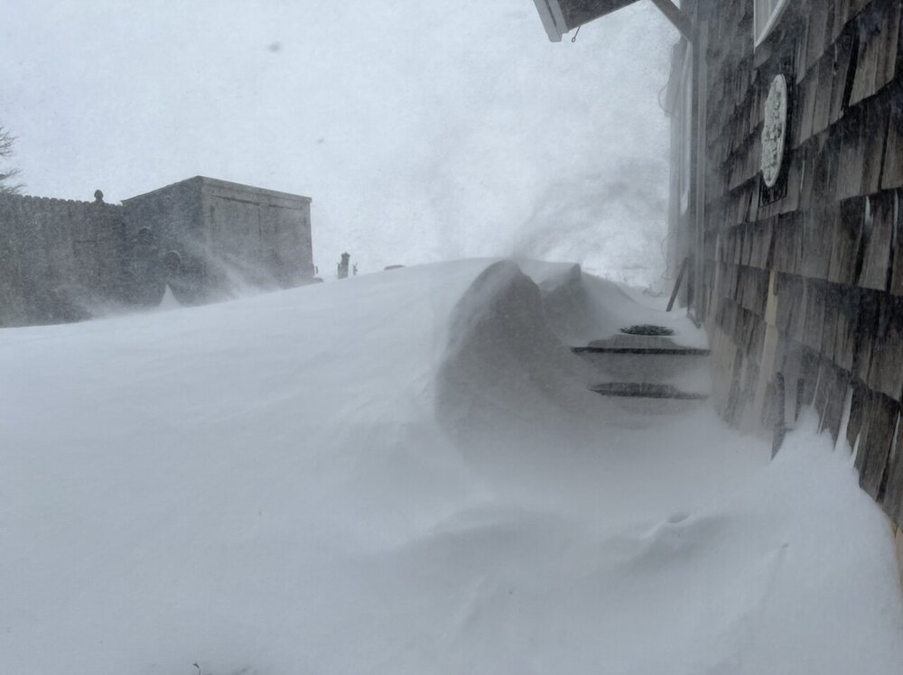
Epic photo
-
 2
2
-
 1
1
-
-
Light snow with larger flakes, prob around 1 mile visibility, estimate of around 6.5” - 7.5” but very variable depending on location
-
2 minutes ago, RU848789 said:
Well, we got some light to moderate snow the past 2 hours and we're now up to 6.25", which is a nice storm, but very likely will fall a bit short of my 8.25" prediction. Part of that is because the NWS predicted 14:1 ratios, so I kind of figured that in, but DonCat in Staten Island reported a 12:1 ratio - if it had been 14:1, I'd be at 7.3" now. No biggie, just interesting to observe. It's still snowing and the radar looks like we might have another hour or two with a shot at a heavier band as the storm pivots and starts heading ENE. For hours I've been watching heavy bands about 10-15 miles east of me falling apart as they move west, but maybe we'll still get one. Oh well, still a fun storm. 20F.
You’ll be snowing through 2ish
-
moderate fine snow continues, would estimate 0.5 mile vis or so, estimate of 5” - 5.5” or so but hard to tell...
-
Light fine snow continues with a dusting
-
Very light snow here..
-
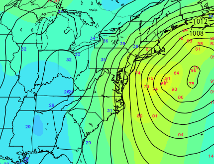
When was the last time we had a northeaster off the coast with a dual structure like that?
-
Just now, MJO812 said:
Sne Mets think the double lows are bullcrap
I agree...
")
-
1
-
-
18Z NAM better initially, than goes back to weird double low structure, still as is 6-12" for most of NYC metro verbatim, but only about 20-30 miles from 12" -18" (NJ coast & C/E LI)
-
2
-
-
6 minutes ago, White Gorilla said:

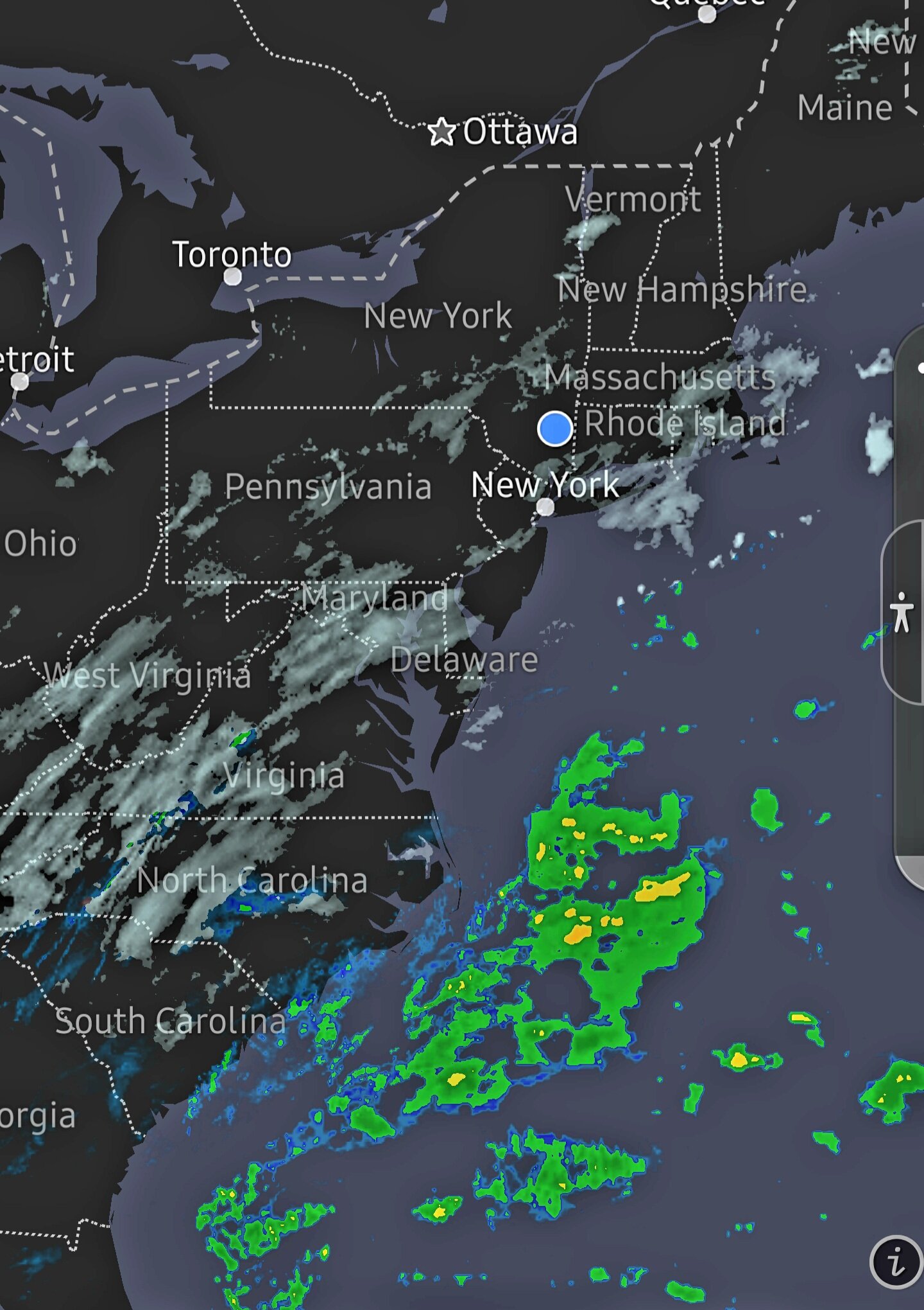
I like the precip development inland over the carolinas...
-
1
-
-
Still snowing, but sun is out...so most all surfaces just wet
-
1
-
-
Although snow coming down at better clip, not really sticking any longer with sun/temps prob just above freezing
-
1
-
-
Moderate snow at the moment, nice size flakes
-
Overall everything still looks on track, GFS improved but also with double barrel, if we can knock that out, monster...if not 6-10"
-
1
-
-
NAM in reality without the double barrel probable confusion would have been EURO/SREF like, I think that is resolved next model run...even still not a bad storm
-
4
-
-
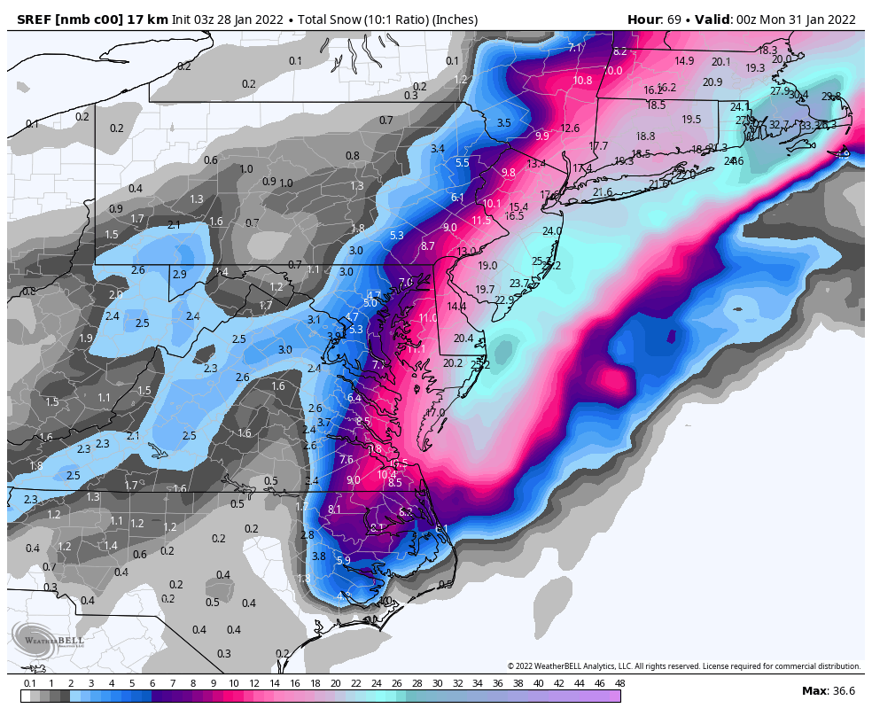
SREF was more than tick I’d say...would bring 10-12” to the delaware
-
4
-
1
-
 1
1
-
-
On 1/22/2022 at 10:02 PM, Typhoon Tip said:
This is a long lead heads up for a potentially strong cyclone over the eastern U.S./ .. western Atlantic, only. That said ...it has enough presentation in the various model clusters, and persistence too, to initiate the focus. Though we are far from a deterministic forecast, this system hm has some risk upside.
Short list of notables:
-- this potential begins 7.5 days away for N GA, and perhaps exits Maine D8.5/9. , ... It's not impossible that this system slows down ( more blw), such that it's into the 31st over the NNE/ME. It is also potentially a larger system size. By virtue of that alone it may take more than a two periods to completely finish a location.
-- as that suggests, this may impact multiple regions from the interior SE U.S. and up along the I-95 megalopolis to SNE, NH and ME. This is a fluid interpretation/subject to change. But when we get into multi-region, multi-faceted systems, even a moderate storm aggregates a major problem.
-- may want to check tides/ lunar, as this system may be ISE loaded and should it slow down... it may protract across more than a singe tide cycle. This type of storm, we have no observed in recent years. Unlike last January, when the super synoptic manifold entered a slowing of progression, with relaxing gradient, but no embedded mechanics, this appears attempting to do so.
Concepts:
We've been monitoring this for a week now, and thus it has established history. Sometimes important events show up at longer leads ... and keep re-appearing - I've been wondering if we're living that. That would be true if it hits a backyard or not... Slowly the various ENS means have become more ominously suggestive. The most recent runs of the GEFs and GEPs ( 18z and 12z respectively..) were still continuing along favorable trends, well established spanning multi cycles.
The sense here is higher than model-climate odds for a significant system. Where it tracks, I have a couple concerns
-- I am noticing the sensitivity is very related to the progressive, vs slowing ( timing this latter arrival) of the flow character. Whenever a guidance cycle has reverted back to conserving the progressive character more so, we end up with runs more so ... like the 12z GFS and Euro. When the subtle pattern change to slow progressivity is apparently directing a give model cycle, we get are bells wrung like the 18z GFS... Not sure at the moment which way that will go... I am also noticing there the flow structures over SE Canada having effects on model runs, but that may be related to those same aspects. This about 50/50 right now. If progressivity persists, this ends up east. If this leitmotif in the ens systems to slow takes place, it would be west because N/S meridian tendencies are increasing, and the system ends up farther W. My haunch is that the slow idea is real... how much? It could be damned in between! ugh... But, if we look upstream, there is an emerging -WPO/-EPO out there D6-10. That is blocking ...native to that tendency, progressivity tends to slow, and the meridian aspect manifests. So that's were I lean presently.. We'll see
-- Plus, there is also the S/W mechanics them selves... If there is more N/stream insert, we may see a subsume phase... vs less, like this 18z run. 18z is a purer Miller A. Should the this slow down and trend Miller B, this is a bright signal and that would likely manifest with equal prominence to put it lightly. But much of this is also indirectly related to above, as those are larger waves creating constructive vs destructive interference nesting.
-- The other aspect ...which is highly experimental.. I've been noticing that the last two significant systems we've covered had a tendency to be too far E in ens means, at this range... and eventually, clusters conceded to the higher resolution/physically tested operational version.
Impressive thread/threat start! Congrats
-
2
-
-
Dusting here, light snow continues
-
1
-
-
Very Light snow Has begun @ of 7:15 AM
-
1
-
-
Obs thread started as snow is starting in C/W NJ
-
2
-
-
Cloudy here, but snow has begun across C and W NJ, were off!
-
2
-
-
STATEMENT FROM BERNIE RAYNO (LOL, I always wanted to write that): I have seen this many times in the past. You ride the NAM on this, it isn't perfect and will likely be overdone in some areas, but overall it will out perform the GFS and EURO. Twitter live at 5:45 am.
-

OBS/DISCO - The Historic James Blizzard of 2022
in New England
Posted
Congrats Scott, must be top 1-4 storm for you? How much you end up with?