

Northof78
-
Posts
387 -
Joined
-
Last visited
Content Type
Profiles
Blogs
Forums
American Weather
Media Demo
Store
Gallery
Posts posted by Northof78
-
-
About 1" here with light snow
-
GFS is about 1" - 1.25" QPF for most of forum
-
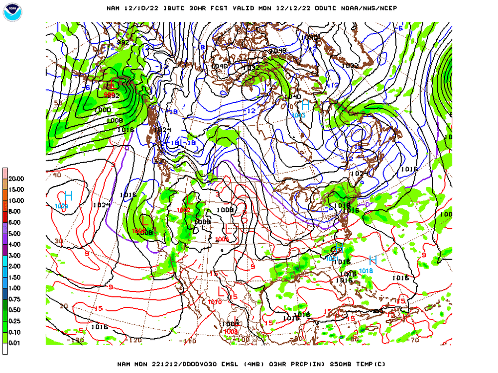
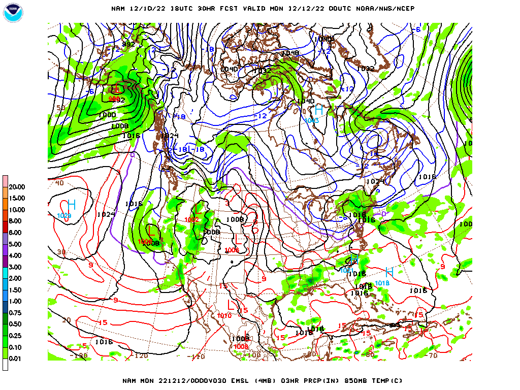
NAM is a nuke for entire region, 2" QPF or more with 850s below 0F all time NYC west, boundary obviously an issue for light stuff before coastal cranks
-
 2
2
-
-
NAM cold and around an inch of QPF
-
1
-
-
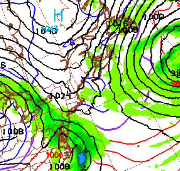
GFS and NAM fairly close in general set up and track now, with a bombing cyclone to our east...If you live north of TTN I think you are good for at least decent snows....
-
 1
1
-
-
EURO snow map looks good?
-
NAM looks pretty good for #1
-
1.3" in Millburn last night, bringing 'season' total to 4.3"
-
43 minutes ago, tmagan said:
At 11:59 P.M. tonight, Central Park will set the record for most consecutive calendar days with less than 1.0" of snow (383 days).
The prior storm split the 2” or so almost 50/50?
-
2.8" final for the storm, and 3.0" for the season, at least got to see heavy/breezy and sticking snow for about an hour this season...
-
Wow, EURO 3/4" line all the way down in Monmouth/Mercer
-
2
-
-
Meanwhile...Ill take a 1-3" .....Book it!
-
Starting Jan 5-8 the pattern looks to turn near average/slightly below average temperature wise and quite stormy...should be a pretty good snow pattern after the 1st week of January
-
1
-
-
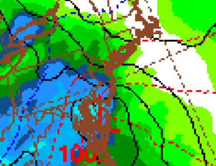
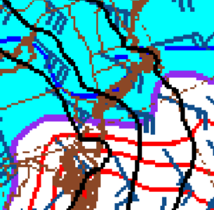
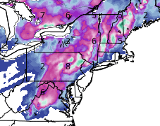
Looks like NAM is a blast of snow on front end (at least) for most on the forum...with cold air actually building SW during this period. frozen/freezing line from Sandy Hook due West after much precip already has fallen @ hour 84. Both graphics are from hour 84 on NAM (with 1st being precip that has already fallen)
-
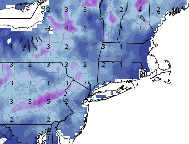
Increasing agreement for an impactful winter storm for some (or possibly most of the forum; especially NW) this Thursday and Friday. Strong Block and blocking low, entrenched arctic/cold air with low passing just to our SE or near our area. Should be a mixed bag storm for many with more accumulating snow likely. Below depictions from 12Z GFS. 12z CMC also shows a nice front end dump for many within forum.
-
1
-
-
New GFS would almost certainly start as snow for all/most and then transition to a mixed bag, timing of max retrograde of cold/arctic air and 50/50 vs. the incoming moisture will determine who on coast gets material snow, verbatim it has VA/MD/DE getting decent front end snow as well down to the coast, should be a decent winter storm for many on here with the block and embedded arctic air
-
Interesting trip into work this morning (Home: Millburn, NJ (just north of 78 and a couple miles W of the Parkway) Work: Oradell, NJ (NE Bergen Country, NJ)
Light dusting on car tops @ home, up to light dusting in Short Hills, then 1/8" or so near Turtle Back Zoo, 1/2 - 3/4" or so near Montclair Golf Club, nearing 1" around Verona and close to 1.5" to 2" the rest of the way once to Little Falls to Oradell.
-
1
-
-
Has turned to light wet snow now...
-
1
-
-
Rain here, but per NWS obs snow line roughly 7-9 miles NW
-
Light mostly rain, but some mangled flakes
-
Very light 50/50 mix here...
-
First flakes for many, accumulating snow for the north, rain for others…latest models looking more robust with precipitation amounts…norlun also possible between C NJ and CT
-
2
-
-
-
very quick transition to light/mod snow now, windy, no accumulation yet
March 13-14th Nor'easter Threat
in New York City Metro
Posted
How much did you end up with?