vortex95
-
Posts
2,208 -
Joined
Content Type
Profiles
Blogs
Forums
American Weather
Media Demo
Store
Gallery
Everything posted by vortex95
-
Sounds like @CoastalWx response! It's not snow, so MEH!
-
It has been in ET transition for at least the last 6 hr. Once the srn part of the eyewall was gone, that was the first signal.
-
If so, they are violating their own directive. Why have thresholds for warnings if they are just deliberately ignored? Why not lower the criteria for a svr tstm warming for winds less then 58 mph in gusts b/c they can still do damage? How about pea size hail? A lot of pea size hail can devastate crops. Issue a warning for that? It is slippery slope. There comes a point of diminishing returns. Excessive alerts eventually become counterproductive.
-
Whoa! So it did happen at the very last min. Just delayed from what the HAFS showed earlier. This is non-trivial rise in what, less than 90 min? From the winds where the pressure was taken, the actual pressure is about 970 mb That barely supports 85 kt winds in a purely tropical system, which Isaias is not and has not been for some time. Operationally, I can see it higher when it makes landfall, post-analysis though? Katrina its rapid weakening phase originally was 120 kt at landfall, but they reduced it to 110 kt. Lili was 90 kt, but reduced it to 80 kt later. Also, when a TC is rapidly weakening near landfall, NHC often keeps it higher for winds that reality b/c they do not want to have ppl et their guard down too much, They clearly did this w/ Milton. So obvious when you saw FL and SFMR winds, and the assigned intensity. I find that disingenuous. We all look at the same data and see things for what they are. Don't insult our intelligence! So models had the right idea, just timing was off, but you really can't expect them to nail down something as mesoscale as an inner core of HU as to when it starts to degrade quickly.
-

-
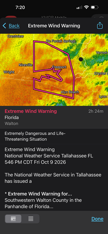
For the EWW issued in FL now. EWW is defined to expect winds *sustained* 115 mph (not gusts). Look at the plot attached. What are the chances of sustained winds this strong *anywhere* but the immediate coast, say within 5 mi? Due to friction, sustained winds drop off very, very quickly once inland. And for a hurricane that is right at the threshold of 115 mph for winds over *water*, you are going to be hard pressed to even see such sustained winds anywhere on land. It goes to show how warnings often are overdone and do not account for obvious factors, like how strong a hurricane is, how large or fasting-moving it is. or how far inland locations are. Objectively, getting winds 115 mph sustained more than a few miles inland at near ground level is practically unheard of more than a few miles inland. Exceptions would be Andrew, Michael and Camille, but Isaias is no where near any of them. You can't treat hurricane landfalls as one-size-fits-all. We have the skill, knowledge, and tech to fine-tune things better and narrow down warning areas these days. And it is not like people this area of the FL PH are not already warned the wazoo a hurricane is making landfall. That very fact has already resulted in major action and lock downs, so people are more than prepared. The word "hurricane" in itself prompts immense action.
-
The big tor threat is often the day after landfall, when it becomes a baroclinic system w/ low-level tropical dew points and all you need is just breaks in the clouds for a little CAPE, and look out! 44 tors in FL from Milton on 10/9/24 This is the largest calendar day tor outbreak on record In October and among the top 5 biggest tor outbreaks in Oct in the U.S. Milton also produced the costliest TC tor on record -- $514M from an EF3 that tracked in St Lucie and Indian River Counties.
-
Stalled fronts in the Gulf sometimes lead to sig HU development. One of most notable ones was Alicia in Aug 1983 that struck HOU as a Cat 3.
-
You can have major HUs in very strong El Nino years. Debby in the western Atlantic was Cat 4 in Sep 1982. Bob in Aug 1991 just off Hatteras was a Cat 3 that went on to hit New England. Erika in the western Atlantic in Sep 1997 was almost a Cat 4. Joaquin near the Bahamas in Oct 2015 was almost a Cat 5. So Isaias occurring here is not atypical overall given the strength of El Nino. The key is that frequency of major HUs in very strong El Nino years is down relative to avg and there is lack of long-tracked Cabo Verde classics.
-
The thing is the models shows the thing getting ripped apart clearly, the primary HU models as well (HAFS) Why wouldn't you think that w/ the shear increasing to 40 kt and that much dry air present? There have been other cases like Isaias,, but also cases where unexpected rapid weakening occurs as well (Katrina and LIli are prime examples). So you can't fault ppl for driving the point home. We have a strong baroclinic situation here, so one wouldn't just ignore than. I would not say rapid intensification not long before landfall used to be definite rarity. That is recency bias largely. Since 1995, we have been in an active phase of the AMO for favorable Atlantic TC activity. Also, we are much better in determining absolute intensity now, esp. for the stronger HUs b/c of things like the GPS dropsonde, which did not come into use until 1998, and the SFMR, which did not exist on recons until 2004. This advancement in tech has allowed us to diagnose *much* better extreme winds that we could not directly measure before. Prior, it was largely just FL winds at 700 mb, but that serves only as a proxy and does not work all the time. So in recent decades we are seeing things we never could detect before, but were always there. Also, and this is a biggie, through the 1960s, if a hurricane was thought be 100 kt or stronger, many recons wouyld not penetrate the eyewall and get into the eye for direct measurements. They would fly only as close enough to get a solid radar scan of the eye, and then turn away. So many HUs were underestimated by 1 or even 2 categories at times in the first decades of the recon era!
-
For a few hours now, the core has been "halved" on radar in terms of an eyewall. I realize there is some attenuation, but if the eyewall ring was complete and intense, we'd easily be seeing a closed ring starting a few hours ago. Ever seem intense TC at extreme range of radars? The eye and a solid eyewall show up very well even 200 nm away! So dry air and shear are have impacted the inner core, however, this has not impacted the central pressure or winds much at all! This shows that the relationship between sig shear and dry air and a HU is complex and it is definitely not one-size-fits-all! As discussed earlier, why did Lili, Opal, and Dennis weaken so much after a solid RI period in and environment not as strongly baroclinic overall than Isaias? Actually, think about Katrina! It went from 150 kt to 110 kt from peak onshore to landfall in ~24 hr with a ton of dry air ingested into the core and quite ragged convective structure compared to Isaias right now. And Katrina was way larger than Isaias, so you would think it could resist dry air intrusions better. Also, Katrina was in Aug. The mean atmosphere as to being conducive for a strong TC that time of year is significantly better than Oct! You don't have troughs of this magnitude cutting across the nrn Gulf in Aug! That being said, the upper level outflow plume for Isaias is outstanding. That unquestionably is a factor here as to keeping it from weakening.
-
I meant Imelda from 2019. You don't see 43" of rain from a TC in the CONUS every day, and Imelda is the second costliest TS on record ($5B), so impact was very high. Net societal impact matters-more for retirement overall.
-
Yes the lack of TC activity has allows the waters to warm more. That is largely a function of El NIno. So suppression overall can lead to enhancements for individual TCs that do manage to develop.
-
Typically yes, but the eye itself can be mess w/ multiple mesovorts rotating around in it! So finding a true wind center is not always easy.
-
That's a good question. Sometimes the outflow from an EPAC TC does impact a TC in the Gulf. In this case, Simon's outflow is well-removed and discrete. The strong upper level trough is dominating the local synoptic environment around Isaias.
-
One thing I do like is stating "tropical storm conditions possible." Yet the actual forecast is for 15 to 25 mph *sustained* winds. That is well below the threshold. Last I checked, tropical conditions are sustained 39 mph or more. So there is hedging here is excessive IMHO. Gusts to TS force are not the same as sustained TS force. They are conflating things. I see this a lot. And really, how often does TCL and esp. ATL, get sustained winds of 39 mph or more? It is practically unheard of. So climo comes into play here. It would have to be an exceptional event for such winds, but Isaias as a hurricane and going ET are not by all forecasts. This is not like Helene from 2 years ago. Just b/c something has a non-zero chance of occurring does not mean you explicitly mention it in a forecast. Once again, hedging and inflating reasonable risk. Wording matters as to how ppl will react, and then you get into the issue of things being cancelled and shutdown *way* too much for a run-of-the-mill event. Also, Isaias will no longer be a TC by the time ATL gets sig impact, and perhaps even TCL. so their wording is incorrect. They should be saying "gale force winds", not tropical storm conditions. This is a slippery slope. Almost every winter storm on the E Coast has winds of TS strength, but you do not call them tropical storm winds! They should be headlining a wind advisory or high wind warning, not mentioning tropical in this case for TCL and ATL.
-
If a HU is a Cat 3 or higher for a U.S landfall, that usually means it gets retired, but not always (Brett in 1999 is an example). Anything less is typically not. The exceptions are when it produces big excessive rains, and you can have only a TS landfall and it will get retired, like Allison in 2001 and Imelda in 2019. And exception will be outside the tropics or subtropics Like a Mid-Atlantic or New England landfall Gloria in 1985 was a Cat 1 at LI landfall, and it was retired. I think that is largely due to the rarity of HU landfalls here, so overall impact is more since these areas not "used to" HU landfalls, unlike from Hatteras S.
-
From a sensible wx impact for winds, there is big difference if a HU is intensifying vs. weakening at landfall An intensifying storm is more efficient in mixing down the very high winds found only 300-500 m up due to better convective updraft/downdraft couplets. This is one reason why Andrew was so nasty. You do not have this in a weakening HU. The convection is not as intense and often only partially encircling the center, so mixing down of the much stronger winds aloft is less. What you can get regardless of the trend, esp. just inland, is some very high gusts due to the collapsing convection in the form of downbursts.
-
We have been "spoiled" since 1995. Trust me, 1970-1994 was a bad time if you like Atlantic TCs. Not that there were not some biggies and some areas got hammered, but overall, it was quite lame.
-
We tend to recall the ones that did RI just before landfall, and that human nature and the wx weenie in us! But the flip side of the coin is just and important. What causes RI is just as important as what causes RW from a forecast POV, both short- and long-term. It remind me growing up, how frustrating it was in ern MA trying to figure out if the tstms coming in from the W would hold together or weaken./collapse. @CoastalWx knows this all too well I know. So that drives you to learn, figure out the deal, and it makes your a better forecaster.
-
That's a good point. TIMING is everything! But I see far too often a wx event is taken as "all day" and so events that will clearly be before or after sig storm impacts are done and do not be to be cancelled. I mean, you now get *indoor* events cancelled for just some typical wind and rain now. Really? We can fine-tune forecasts better than ever now w/ models like the HRRR, RRFS, and HAFS, so we do not have to just issue a generic, blanket forecast. esp for the short-range. Having this capability saves an enormous amount of $$ and allows business and commerce to function better. It reminds me of something years ago. One evening, I went out to get pizza, and when I picked up my order, the person said "it's been slow tonight b/c of snow forecast!" You know what the forecast was? 1-3" of snow starting *after* midnight. So my previous posits about business and commerce being impacts is valid, and it hurts revenue for many businesses, big and small. You see how incessant hype and not quantifying risks/threats properly are detrimental to society. Cancellation of a major sport event is non-trivial as to costs, and it goes far beyond just that single event. They have to reschedule and that has downstream impacts often to the entire league. I often ask myself, what if the SB was in MSY or MIA, and there was a MDT or HIGH risk for svr wx for that day? I would not want to be the one to make the decision! In this case, the ante is extremely high on both sides! Actually, I do recall a case like this. In 2004, the Indy 500 was held despite a HIGH risk svr and a sig tor outbreak was likely. And when the event was over and people were leaving the area, there were tornadoes occurring in the IND area not more than 5 mi away!
-
Wow @CoastalWx chiming in on AmrWx somewhere else than the New England forum and the sports threads? Be still my beating heart! Guess he has to breakup this "boring" pattern somehow!
-
It will be like a typical non-tropical low pressure once inland, like a Miller A storm. Atlanta has been through this many times. The problem is media hype and knee-jerk reactions from authorities end up resulting in overdoing the cancellations and shutdowns. Just b/c this storm has (had) a name on it, does not make it different overall once it goes PT/ET and for locations far inland, yes there are exceptions, like Helene, but that's not the case here. Many PT/ET storms out of the Gulf have produced the same impacts to the SEUS as Isaias will. I posted earlier about the Gulf storms in Oct 1992 and 1994. You watch, the ET part of Isaias is going to impact the entire E Coast. It will be no different than typical Nor'easter and not even as strong or impactful as the Nor'easter last month, say DCA-BOS. but it will be treated as "worse" b/c it was a former hurricane and you'll see unnecessary cancellations for it. There is no scaling or quantification of wx events these days, all are the same as to being worst ever, unprecedented, or absolute high-end events as to impact that we all have to hide and cower in fear from. Being constantly "held hostage" by the wx is not a good thing. esp for business and commerce. You can't hide behind the excuse "better safe that sorry" for every single wx situation. This mindset has real impacts. The door swings both ways here.
-
HAFS A/B yesterday did an excellent job on showing Isaias deepening in the last 12 hr and its current intensity. For the past 2 years these models have shown significant improvement over the previous TC models. I seem to recall last year the HWRF and HMON were to be discontinued, but that has not happened IMHO, there are already too many operational models the exist or available. More is not always better, and too many can distract from proper subjective forecast skill. You get *one* model that is an outlier, and that can sway you away from a better forecast. Also, the less scrupulous people on social media looking for clicks/like will often post the model that shows the worse case scenario, even if it obviously out to lunch. That makes our job that much harder because often we have to spend an inordinate amount of time debunking wild or bogus forecasts. I know some are not thrilled with the NAM and it derived products ending soon, but eventually we do need to move forward and the RRFS replaces the NAM. The NAM as a model and early name, ETA, has been around for 33 years, so time to move on. Also, from the big Nor'easter last month, the RRFS was too aggressive in showing a tropical transition for this storm, so that suggests it may not do well for TCs. Has anyone been following the RRFS as how it has handled Isaias so far?
-
Oh yes Dennis. That underwent rapid weakening leading up to landfall as well, after rebounding big time once off Cuba.