stormdragonwx
-
Posts
512 -
Joined
-
Last visited
Content Type
Profiles
Blogs
Forums
American Weather
Media Demo
Store
Gallery
Everything posted by stormdragonwx
-

MO/KS/AR/OK 2022-2023 Winter Discussion
stormdragonwx replied to JoMo's topic in Central/Western States
Heh ironically my station down here did the opposite on the 10pm news. Too funny how they flipped.
-
MO/KS/AR/OK 2022-2023 Winter Discussion
stormdragonwx replied to JoMo's topic in Central/Western States
@ouamber Its also digging and slowing down a bit more when you look at the model trend loops. This means nearly everyone will be seeing more snow. I am still just impressed with how well the models have overall locked on with this system. -
MO/KS/AR/OK 2022-2023 Winter Discussion
stormdragonwx replied to JoMo's topic in Central/Western States
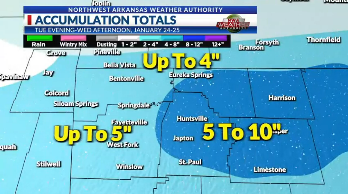
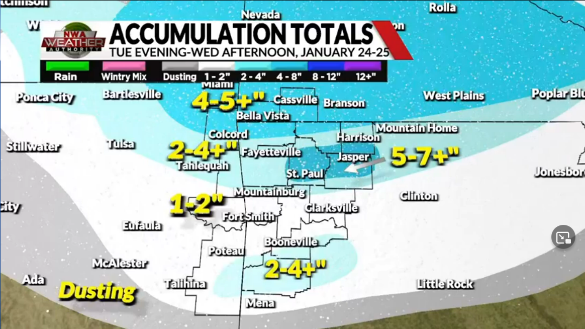
Local forecast totals from KY3 in Springfield and KNWA in Fayetteville. Naturally the guys here in Arkansas are playing it more conservative. Its not too often we see 8+ here.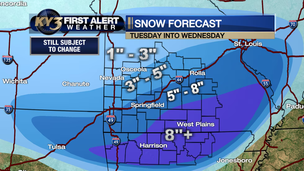
-
MO/KS/AR/OK 2022-2023 Winter Discussion
stormdragonwx replied to JoMo's topic in Central/Western States
Crazy to see the NAM is now being more bullish than the GFS. (Posting Kuchera because I personally feel the 10:1 totals are too unrealistic approaching 2 feet in spots) -
MO/KS/AR/OK 2022-2023 Winter Discussion
stormdragonwx replied to JoMo's topic in Central/Western States
00z GEFS a bit disorganized on agreement tonight. Will have to see if this trends after tonight now that the system is onshore. I suspect its a bad run.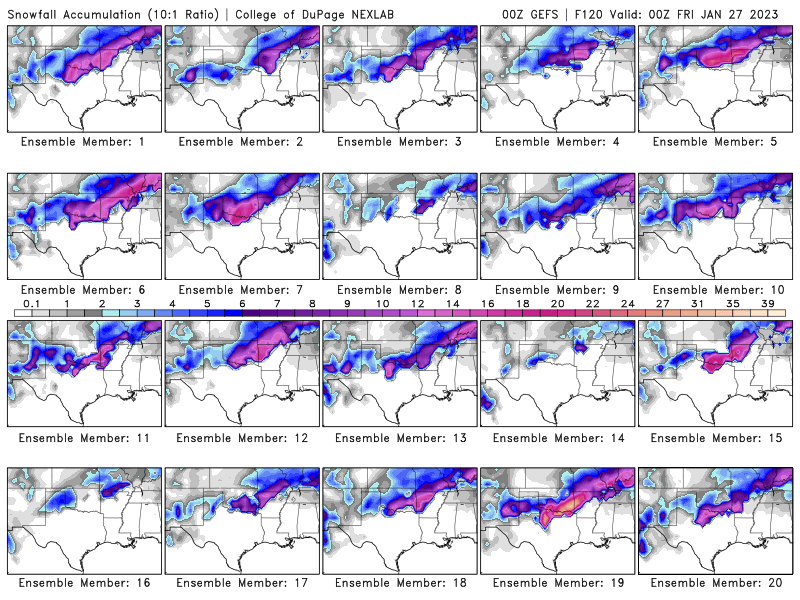
-
MO/KS/AR/OK 2022-2023 Winter Discussion
stormdragonwx replied to JoMo's topic in Central/Western States
Indeed the NAM has nudged north a bit with more widespread heavy totals and seems to be following what the GFS and Euro have been showing. I am still skeptical of what the actual temps will be on the day of so the 10:1 ratio might be exaggerated but I also think the "Snow Depth" parameter that some are swearing by is underdone. Best to take the two and work towards the middle. -
MO/KS/AR/OK 2022-2023 Winter Discussion
stormdragonwx replied to JoMo's topic in Central/Western States
As mentioned above the first NAM samplings in range of the storm going out to 84 hours is encouraging. I expect more than likely this will probably shift back north slightly in the next few runs. -
MO/KS/AR/OK 2022-2023 Winter Discussion
stormdragonwx replied to JoMo's topic in Central/Western States
I give it another 24-36 hours to let the models settle. This is a classic case of the models shifting back & forth on the track as the system gets sampled. -
MO/KS/AR/OK 2022-2023 Winter Discussion
stormdragonwx replied to JoMo's topic in Central/Western States
Don't get me wrong, I would actually love to see a repeat of the Feb 2nd, 2011 event and there are some similarities starting to take shape here nearly 12 years to the day, but I feel we got a ways to go just yet before I can actually say it. lol -
MO/KS/AR/OK 2022-2023 Winter Discussion
stormdragonwx replied to JoMo's topic in Central/Western States
Don't jinx it and it all falls apart by Sunday night. lol -
MO/KS/AR/OK 2022-2023 Winter Discussion
stormdragonwx replied to JoMo's topic in Central/Western States
haha The good ol' GFS teasing us with crazy totals days before the event as usual. Now if the Euro does this later on as well, its all hands on deck. EDIT: UKMET is not as crazy but shows a very similar swath. Waiting to see what the Euro and Canadian show here shortly. -
MO/KS/AR/OK 2022-2023 Winter Discussion
stormdragonwx replied to JoMo's topic in Central/Western States
00z Euro and UKMET also going all gung ho with this storm. -
MO/KS/AR/OK 2022-2023 Winter Discussion
stormdragonwx replied to JoMo's topic in Central/Western States
00z GFS and Canadian look fun. -
MO/KS/AR/OK 2022-2023 Winter Discussion
stormdragonwx replied to JoMo's topic in Central/Western States
I'll take it. Lock... it... in... lol -
MO/KS/AR/OK 2022-2023 Winter Discussion
stormdragonwx replied to JoMo's topic in Central/Western States
Well the majority of this month looks depressing (and boring)... so much for winter. Hopefully February sticks to its historical standard and delivers. -
January 2nd and 3rd Severe Weather Threat
stormdragonwx replied to DanLarsen34's topic in Central/Western States
Eastern OK now has 2 active tornado warnings on the cells that blew up along US 69. -
January 2nd and 3rd Severe Weather Threat
stormdragonwx replied to DanLarsen34's topic in Central/Western States
The new Tornado Watch was recently issued with 60/40 probs. That area of clearing over the triple point could become interesting. Not good for people in this area and to the east of there.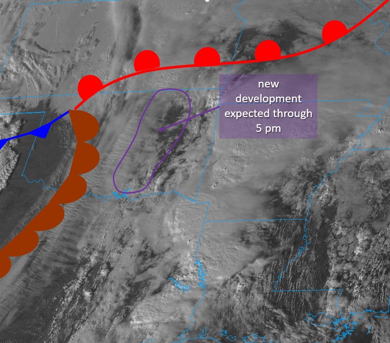
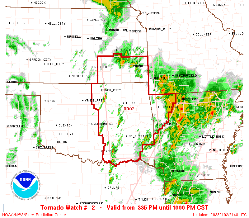
-
January 2nd and 3rd Severe Weather Threat
stormdragonwx replied to DanLarsen34's topic in Central/Western States
Interesting new Meso Discussion. https://www.spc.noaa.gov/products/md/md0005.html Also the convective outlook expanded the 10% hatched area further north and west. -
MO/KS/AR/OK 2022-2023 Winter Discussion
stormdragonwx replied to JoMo's topic in Central/Western States
Hard to say here in Fayetteville, very powdery wind blown snow. Measured 1/2" in some spots and 2" in others. -
MO/KS/AR/OK 2022-2023 Winter Discussion
stormdragonwx replied to JoMo's topic in Central/Western States
Looks like some mesoscale banding might be setting up with this snow squall. Appears to be back building across N OK. https://radar.weather.gov/?settings=v1_eyJhZ2VuZGEiOnsiaWQiOiJuYXRpb25hbCIsImNlbnRlciI6Wy05NS4wMzYsMzUuOTgyXSwibG9jYXRpb24iOm51bGwsInpvb20iOjcsImxheWVyIjoiYnJlZl9xY2QifSwiYW5pbWF0aW5nIjp0cnVlLCJiYXNlIjoic3RhbmRhcmQiLCJhcnRjYyI6ZmFsc2UsImNvdW50eSI6ZmFsc2UsImN3YSI6ZmFsc2UsInJmYyI6ZmFsc2UsInN0YXRlIjpmYWxzZSwibWVudSI6dHJ1ZSwic2hvcnRGdXNlZE9ubHkiOmZhbHNlLCJvcGFjaXR5Ijp7ImFsZXJ0cyI6MC4yNCwibG9jYWwiOjAuNiwibG9jYWxTdGF0aW9ucyI6MC44LCJuYXRpb25hbCI6MX19 -
MO/KS/AR/OK 2022-2023 Winter Discussion
stormdragonwx replied to JoMo's topic in Central/Western States
Yup its here. Just passed thru SE Fayettevlle. Had a nice shelf cloud with it too. Getting cold and windy quick. -
MO/KS/AR/OK 2022-2023 Winter Discussion
stormdragonwx replied to JoMo's topic in Central/Western States
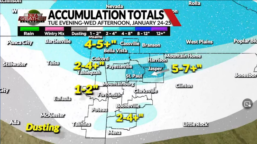
TSA revising down their totals per their Decision Support page. Of course they have always been conservative on forecasting. https://www.weather.gov/tsa/dsp Though it does make me wonder if they are either following the NAM or ICON model. The latter has halved the totals from yesterday's runs, especially on the southern edge. -
MO/KS/AR/OK 2022-2023 Winter Discussion
stormdragonwx replied to JoMo's topic in Central/Western States
Indeed its always fun to be surprised by an over-performing storm but I feel more than likely this is what most of us will see. -
MO/KS/AR/OK 2022-2023 Winter Discussion
stormdragonwx replied to JoMo's topic in Central/Western States
Yeah I think south of 412 will be lucky to see an inch 2" tops. IMO -
MO/KS/AR/OK 2022-2023 Winter Discussion
stormdragonwx replied to JoMo's topic in Central/Western States
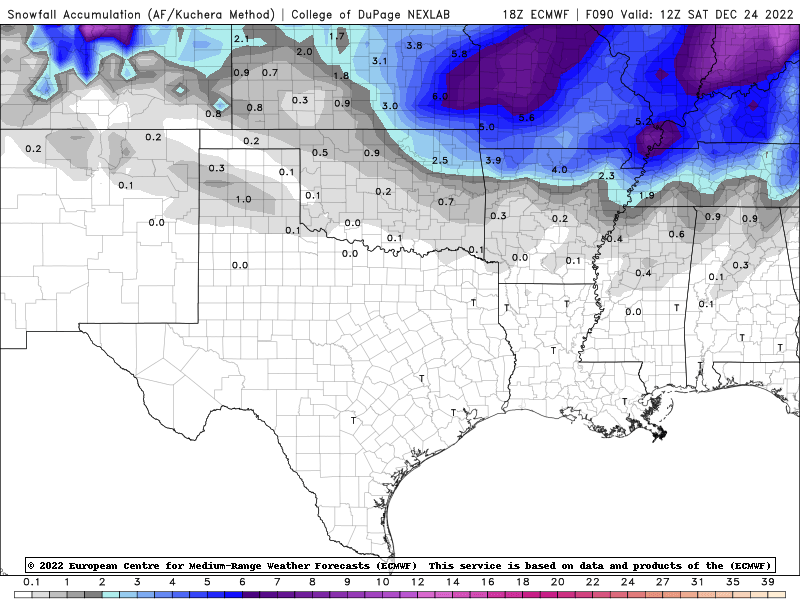
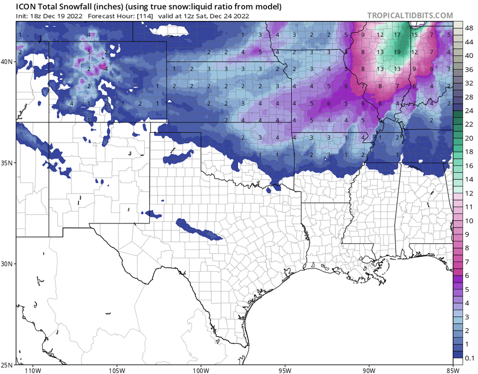
Man, who killed the forum? lol Here is the 18z Euro. And the 00z ICON