SUNYGRAD
-
Posts
251 -
Joined
-
Last visited
Content Type
Profiles
Blogs
Forums
American Weather
Media Demo
Store
Gallery
Everything posted by SUNYGRAD
-
Crazy high concentrations...

-

-

-
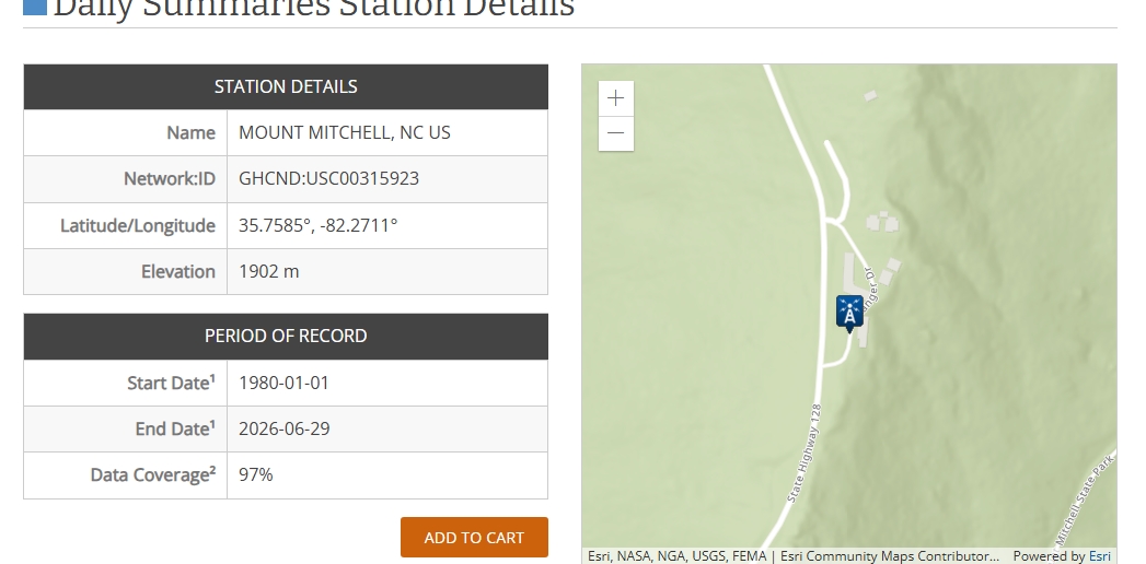
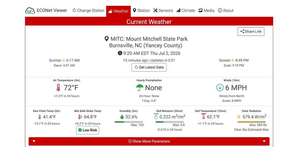
It appears to different high temps at Mt Mitchell yesterday. Never really gave much thought until now----- but the 75 F (NWS local data from Greer) from the MOUNT MITCHELL, NC site and 78.4 F from Mount Mitchell State Park (operated in cooperation NCDEQ and NC Climate Office). As best I can tell, they are both at the same location, but slightly different official elevations and also LAT/Longs. One is 1902 meters and the other is 1894. Does anyone know why the differences? The elevations could be a reporting error on one but was wondering if two instrument locations or just co-located? Just a little surprised by the temp differences----maybe just me?

-
That's terrible. Down near the campground?
-
Grandfather broke 80 today and hit 81 the best I can tell. Could tomorrow make a run at 83?
-
Saw that. I think some clouds helped keep it down a degree or two.
-
remarkable at Mt Mitchell this hour it is already 72 F.
-
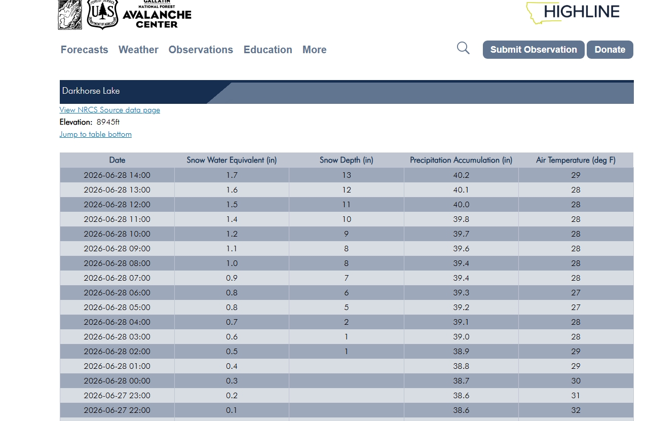
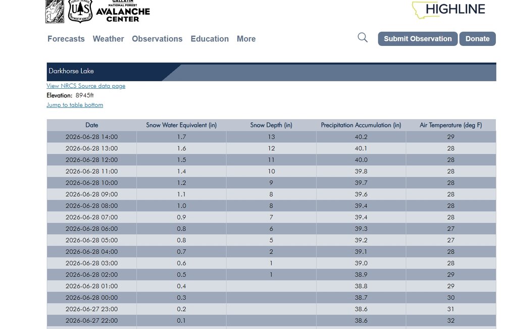
Update: 22 inches as of 9:00 local time today at Darkhorse Lake. I bet if this was July it could be a state record for the month.
-
Some crazy weather for sure, snowfall already exceeding 12 inches out in western MT for this time of year----even for the higher elevations..
-
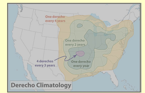
Generally hard to forecast in advance, sometimes even during the event, but this weather pattern going into next week reminded me of Derechos. Rather good reading and understanding of aspects of them here- Facts About Derechos - Very Damaging Windstorms. There are other weblinks within this document too. Hard to say if anyone in some of the target areas, including NC, will see one----just something to be mind of. I do remember the 2012 event here in parts of NC, but do not recall any noteworthy events since then----at least here? One thing I learned is the definition has recently updated for Derecho-
-
National Weather Service
-
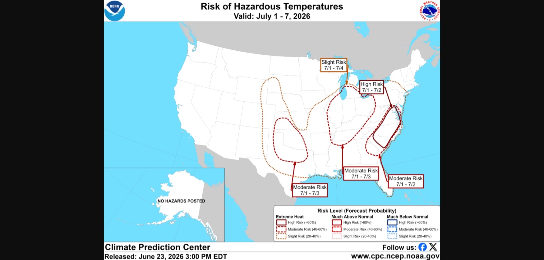
"The combination of strong subsidence, lack of clouds, dry ground, and a downslope low and mid level flow - could potentially yield a near historical heat event bringing very dangerous conditions. Some guidance is now forecasting a few disturbances in the NW-N flow aloft riding into the region by Friday and Saturday the 4th. This may be enough to trigger either widely scattered or scattered (20-30 percent chance) of afternoon or early nighttime thunderstorms perhaps bringing some temporary cooling."
-
still a problem.
-
Hmmmm. This for the 2nd, not the 3rd or 4th. Hard to pinpoint local or even moving clusters at this point going into the 3rd or 4th, let alone one model output this far out. Day of or overnight should/could have more bearing on indices is what I was thinking earlier. Agree dry some, but my opinion is this is not particular strong CAP given the LI, PW. Temperature slight increase. Some marginal instability around -2 with LI. I believe some of the other modeling that I looked at has some convection for the 3rd and 4th.
-
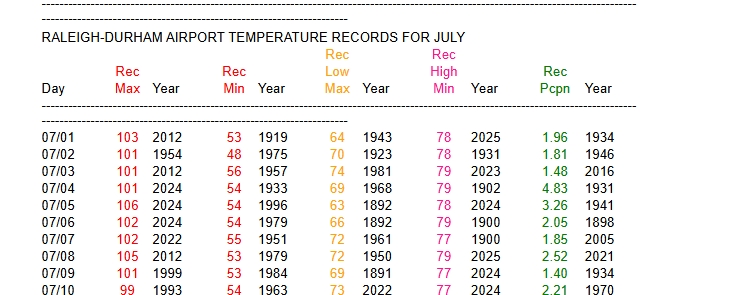
Daily records for Raleigh-Durham Airport Temperature Records
-
It will be interesting to see how high heat indices are too. One thing that could keep temps down a few degrees is any thunderstorms or complexes----but this could increase the heat index some-----even with some daytime mixing. I think the highest I saw several years ago was 122 F down/around Fayetteville.
-
-
Don't recall ever seeing these types of high temps for a large area of NC from any model output in some time. The foothills in triple digits are rather remarkable and temps in central VA as well. If this was to hold, one might expect the all-time record high 81 F for Mt. Mitchell could be challenged on the GFS. Grandfather's all-time record high of 83 may be in reach. Of interest is some remarkable heat waves ----Historic Heat Waves in the Carolinas
-
I believe an all-time of 104 is in jeopardy in Greensboro either JULY 3rd or the 4th, we shall see- I believe the highest temperature ever recorded in Raleigh, North Carolina was 106 °F which occurred just two years on July 5, 2024.
-
I believe the highest temperature ever recorded in Raleigh, North Carolina was 106 °F which occurred just two years on July 5, 2024.
-
No significant changes with drought in NC with today's update-
-
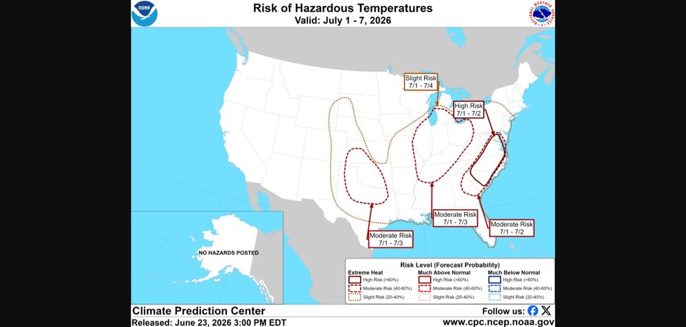
High risk not issued very often this far out.
-
-
Funny from recent discussion NWS in Riverton, WY National Weather Service "Ridging should build across the area on Friday, bringing a warmer day and fewer showers and thunderstorms. The weekend forecast depends on what happens with an upper level low that will be dropping in from British Columbia. A few ensemble members show impacts as early as Friday night. However, models are usually too fast with these and most impacts would be Saturday or Sunday. And it is here where I bring up the famous Monty Python quote, "Now for something completely different".