

Modfan2
-
Posts
2,327 -
Joined
-
Last visited
Content Type
Profiles
Blogs
Forums
American Weather
Media Demo
Store
Gallery
Posts posted by Modfan2
-
-
-
9 minutes ago, Damage In Tolland said:
We over .Possibly way . S Way
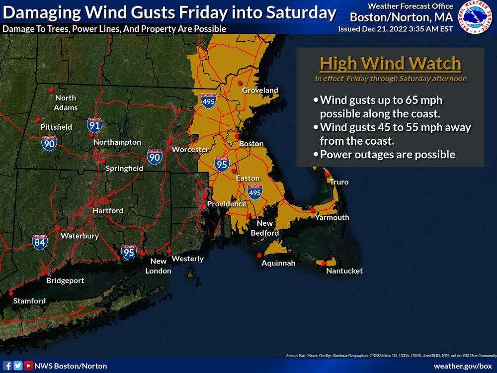
Cmon, we don’t even have a high wind warning; if you gust to 50 you’ll be lucky. Your only hope is some convection to mix some down. I am just hoping for breezy conditions and rain and be done with it!
-
20 minutes ago, moneypitmike said:
Look again.
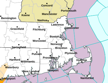
When you click on your area it only show Wind Advisory
-
 1
1
-
-
46 minutes ago, CT Rain said:
I don't get the "wind forecasts always underperform" thing. I feel like most of our forecasts verify fairly well at the ASOS stations. If you're looking at the HRRR/Euro or whatever raw model output though and taking that as a forecast you're going to be disappointed.
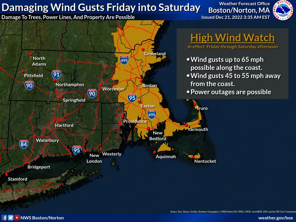
Box only has CT zones in Wind Advisory, do you think that’s sufficient? I expect highest area to gust near 55.
-
23 minutes ago, FXWX said:
Can you send link to this page at BOX... cannot locate it for some frigg'n reason...
Grab it off twitter
-
21 minutes ago, 40/70 Benchmark said:
Makes sense....have a last second miracle trend so that its close enough for me to make out the fingerprint of old man winter as he flips me the byrd.
What impact does that have on winds?
-
 1
1
-
-
11 minutes ago, Ginx snewx said:
Definitely. HRRR gone wild with the convective elements bringing the winds and the dry slot mixing. Crazy if true.
.thumb.png.7da50dc95b3cc9d4c1052f71b299acd7.png)
.thumb.png.3418a41543e7f6a1b1b67df21899e26d.png)
.thumb.png.451de0a23aaedeaa69917e75edbd4e60.png)
Wow, bullseye right there for Ekonk Hill….just wondering how much a difference elevation makes with this if anything; me sitting at 275’ vs you at 600’ish?
-
4 minutes ago, Ginx snewx said:
Normally Synoptically a 1053 high to our north moving nne into Eastern Canada locking in would produce here however we are looking at an extremely rare event. Have to admire this one.


Seems highest winds east of us unless…..we get any convection to bring winds down.
-
 1
1
-
-
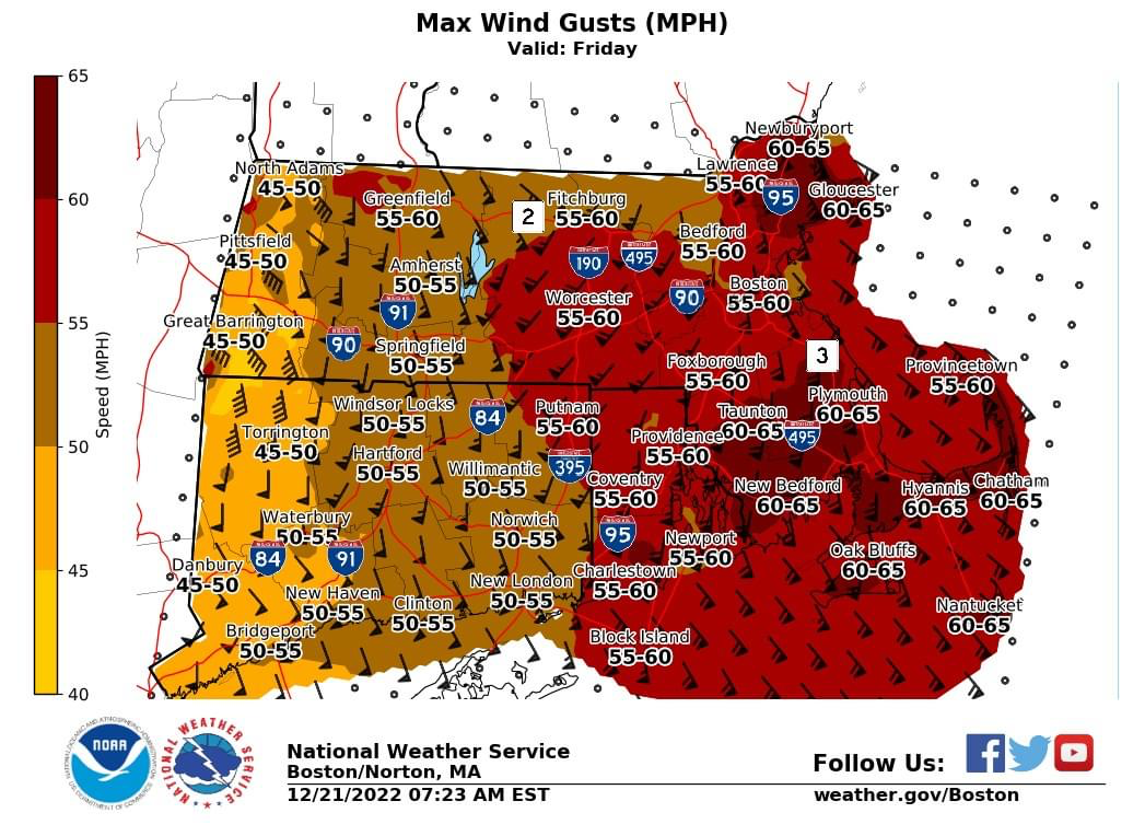
Latest wind gust from BOX
-
 1
1
-
 1
1
-
-
Hope @Damage In Tolland survives the Wind Advisory; lots of cans and bottles of IPA’s going to be thrown about in Tolland!
-
2
-
-
Think this ends up being similar to last weeks storm with possibly some higher winds in SE Mass
-
3 minutes ago, STILL N OF PIKE said:
Peak gust O/U at blue hills 71 mph
Take the under at 63 mph
-
56 minutes ago, Damage In Tolland said:
MR Speed would be an appropriate song here, and probably a top 5 and most underrated song in their catalog!
-
-
1 minute ago, rimetree said:
12z NAM seems to have cut back on the QPF here...I'll take it.
Dry slot?
-
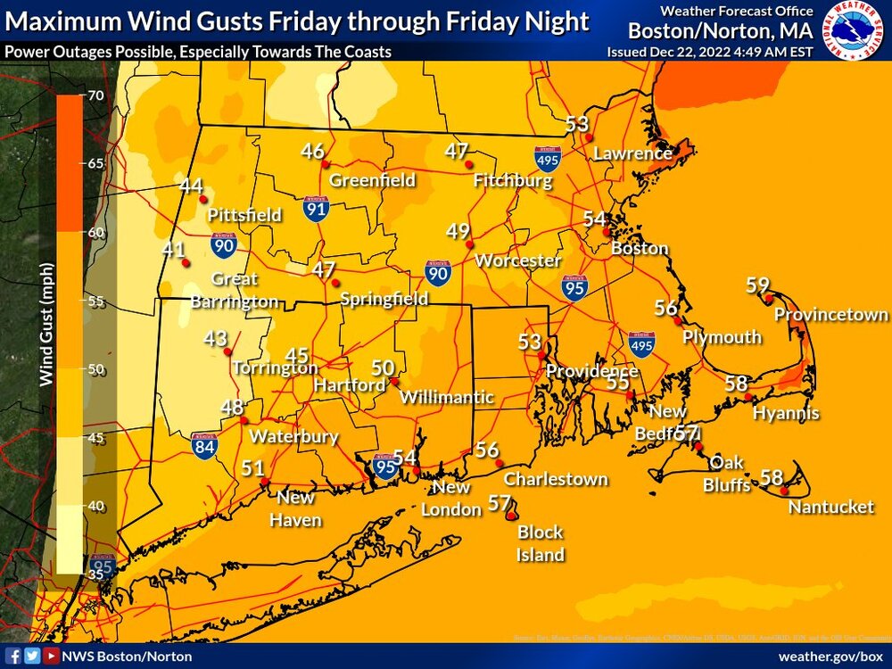
Box likes eastern areas of MA/NH for the highest winds.
-
2
-
-
1 hour ago, HoarfrostHubb said:
I would watch for 50-65mph gusts. But I would not expect everyone to get those.
I would except the worst at the coast or higher elevated locations
-
1
-
-
1 minute ago, HIPPYVALLEY said:
The thing is we could see models all jump a step back west over the next day. Best to keep your expectations quite low.
I have none, just expecting rain and breezy conditions
-
1
-
-
Here’s a thought is this done ticking east? Not saying I am expecting frozen here but but IL and IN we’re expecting heavy snow that is now over PA/NY?
-
1
-
-
Ground pretty saturated from last week; thankfully for the flash freeze because could be run off issues
-
8 minutes ago, mcglups said:
It will be interesting to see how cold of an airmass develops in New England (rooted in the snow cover from the previous storm) and whether the current modelling resolves it in initial conditions.
Umm, where’s the snow cover?
-
1
-
-
Post holiday GTG on deck at Waterfront Mary’s on Webster Lake? Lol
-
-
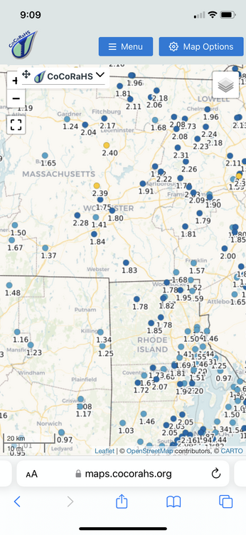
Some of the rainfall totals S ORH county into E Mass and RI are pretty impressive
-
1
-
.png.58941a448378c820a15db540be1b0a37.png)
.png.78734aef73a0d7afab7b32958b482df9.png)
.png.0af965a9c28a445e46bcc163f240ffb2.png)


"We're gonna need a bigger plow..." Massive, persistent singal now emerges discretely in the models, 20th-23rd
in New England
Posted
57 and about 1.16 of rain so far; winds screaming in the night!